A circular route between Burntisland and Kinghorn utilising the “unofficial” coastal path along Pettycur Sands. This route is not possible at high tide without getting wet feet. The Binn can optionally be included on this walk.
- Distance with The Binn: 6.4 miles / 10 km
- Ascent with The Binn: 820 feet / 250 m
- Distance without The Binn: 5.5 miles / 9 km
- Ascent without The Binn: 490 feet / 150 m
- Terrain: Beach walking, short road sections, unsurfaced paths/tracks (could be muddy)
- Start/finish: Burntisland Links car park
Route Map
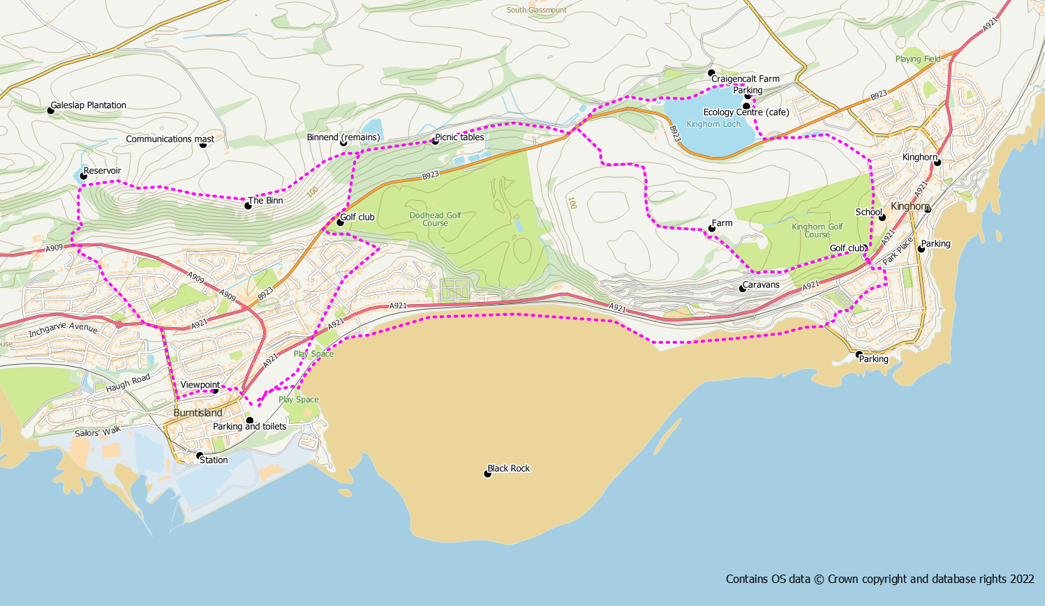
Start from the Burntisland Links car park and walk across the links, under the railway to the promenade. Follow this along to the end then head down on to the beach. Walk along the beach or if it is low tide, you could also head out to the Black Rock and include this in your walk, When you reach Kinghorn, head up the steps to Pettycur Harbour. From here you need to make your way to the main road. The shortest route is by using a flight of steps up past the grave yard but you could also follow the coastal road round. Cross over the main road and take the road up the hill to the golf club.
At this point there are two possible options to reach Kinghorn Loch.
- Pass the golf club on your right and the caravan park on your left and continue on up the hill. This track goes over Grange Hill around a farm and down the other side with excellent views over to Kinghorn Loch. When you reach the public road cross over and go left to reach the Binnend path with a small marker post (not the signed Kinghorn Loch path).
- Alternatively, use the path from the club house around the outside of the golf course followed by the Burnside path to reach Kinghorn Loch. Cross over the road and pick up the path on the opposite side around the loch. Pass the Ecology Centre and walk round to the north side of the loch. From here either the woodland paths or the track from Craigencalt Farm can be used to reach the main road at the west side of the loch. Turn right along the road for a short distance to reach the start of the Binnend path with a small marker post. This route is about 1/2km longer than option 1.
The Binnend path takes a high-ish route back to Burntisland passing a picnic site with good views out over the Forth. After about 1km a crossroad junction is reached close to the site of Binnend village. At this point the routes with and without The Binn diverge.
With the Binn
At the cross roads go straight on over a stile and follow the grassy path up to the Binn summit. After taking in the views, continue in the same direction now going downhill until you reach a small reservoir. At this point go left on a path across a field and over a stile into a wooded area. Follow the path down hill to emerge at the roadside.
Cross over the road and go into Grange Road on the opposite side accessed via a footpath. At the end of Grange Road cross over the main road and then go right into Kirkton Road. This will take you all the way down to the High Street where you can turn left to walk back to your starting point. However, if you are still feeling energetic go left up a set of steps before you reach the High Street to follow a path that takes you up to a viewpoint. After the viewpoint the path goes down more steps to reach the east end of the High Street and the Links.
Without the Binn
When you reach the cross roads you should turn left steeply down hill to the road where you turn right towards Burntisland Golf Club. After the golf club look for a path on your left which leads into Burntisland. At the end of the path use Kirkbank Road to return to the Links.
Extending to Kirkcaldy or Aberdour
It is possible to extend this route to either Kirkcaldy or Aberdour using the coastal path and returning via inland routes. These options are described on separate pages.
