The Fife Pilgrim Way is a long distance route. It was opened in July 2019. It connects West Fife with East Fife via routes used by medieval pilgrims. The overall route brings together a network of existing paths, tracks, core paths and rights of way. These are joined into a single journey across the heart of Fife.
The route described below is split into 7 convenient sections, each between 8 and 11 miles. Each start and end point is linked by a single bus service. This makes it easy to do a one-way walk whilst leaving a car at one end.
The route is waymarked throughout its length. Some of the waymarkers can be a bit subtle in built up areas.
Much of the route is on hard surfaces. Over a third is on road and pavement. Hence, trainers may be a better choice than boots for footwear. There are some unsurfaced path sections. There are also a couple of field edges where the route could be a bit muddy after rain. The description below includes suggestions of alternative routes to miss out some of the road and town walking.
Section 1a: Culross to Dunfermline
- Distance: 13.5 km / 9 miles
- Ascent: 150 m / 500 feet
- Terrain: Surfaced paths, pavements, some unsurfaced path
- Facilities: Free parking in Culross, toilets and refreshments in Culross, Pay and Display parking in Dunfermline centre, free parking at Leys Park Road, Dunfermline, toilets and refreshments at Carnegie Library
- Bus: Stagecoach no 8
Route Map

The route starts from the main road in Culross between the play area and West car park where there is a new interpretation panel. Follow the waymarkers across the road, along the cobble streets past the Palace and up the hill to the Abbey. The Abbey can be explored both inside and out before picking up the grassy waymarked path that takes you steeply downhill back to the main street. Turn left along the road to reach the East car park. At this point the official route continues along the main road passing the remains of St Mungo’s Chapel before turning right into Station Path to reach the coast at a level crossing.
Alternatively, you could miss out this section of main road and walk through the East car park to join the coastal path where you then go left for 300m to reach the level crossing.
If you are not bothered about visiting the Abbey and other historic parts of Culross, you could just take the coastal path from the West car park along the sea front to reach the level crossing. This option also misses out the steep hill up to the Abbey.
Cross over the railway and keep straight on, away from the coast following the markers for both the FPW and FCP. After about 1.3 km follow the markers over a footbridge to a car park on the other side of the railway. Leave the car park in an easterly direction on a path which soon joins the main road pavement. Keep to the road, crossing a river bridge (the Bluther Burn) at the entrance to Valleyfield Woods.
A marker post indicates right, down a dead end piece of road to meet a well made path where you turn left. Soon the path reaches the houses of Low Torry before rejoining the main road to go under the railway bridge.
The official route continues on along the pavement through Torryburn and for a further 1 km alongside the road out of the town. Leave the road when you reach the traffic lights after the cemetry by turning right through a new gate onto a section of track.
This section of uninspiring road walking can be avoided however, by following a parallel route through the nearby woods. Walk through Torryburn and turn right into Adia Road on exiting the village Better still, walk through the car park, along The Ness path, Low Causeway, Craigflower View and through the grounds of Craigflower House to reach Adia Road that way.
Once on Adia Road, there is a core path purple arrow marker indicating a woodland path on the left hand side. Simply follow this undulating unsurfaced path through the woodland. Beyond the trees and the Torry Burn the main road is blissfully out of sight although you will still hear it at times. When the path leaves the woods, turn right on to the tarmac track which is part of the official route.
The track terminates at the busy A985 road. Take extreme care and cross the fast and busy road to reach the farm track opposite. When the farm track splits at a fork, keep left past the houses at Muirside, over the railway and into the village of Cairneyhill. Turn right and walk along the pavement for about 750m to the edge of the village.
Turn left opposite the church on to the track signed as “Hilton Road”. This next section is pleasant woodland / farmland walking for about 2km to reach the village of Crossford. Cross over the road and continue straight on for 250m to reach a farm road signed for Milesmark and Dean Plantation. Walk up this road to the farm where you go right following the signs on to the Berrylaw path for Dunfermline. A pleasant 1.4km walk on a path across the fields (could be muddy in some places after rain) brings you to the outskirts of Dunfermline.
Cross over the road and follow the marker posts along Cameron Street, turning right into Maitland Street. Cross over the main road (pedestrian crossing nearby) into Pittencrief Park (Dunfermline Glen).
Keep right at the signpost under the bridge following the path up the hill towards the Abbey. If you’re not in a hurry you may wish to spend some time exploring the park.
Section 1b: North Queensferry to Dunfermline
- Distance: 13.5 km / 8.5 miles
- Ascent: 240 m / 780 feet
- Terrain: Mostly pavements and hard surfaces
- Facilities: On street parking in North Queensferry, refreshments in North Queensferry, Toilets and part-time cafe at Inverkeithing Civic Centre, Pay and Display parking in Dunfermline centre, free parking at Leys Park Road, Dunfermline, toilets and refreshments at Carnegie Library
- Bus: Stagecoach 7D
Route Map
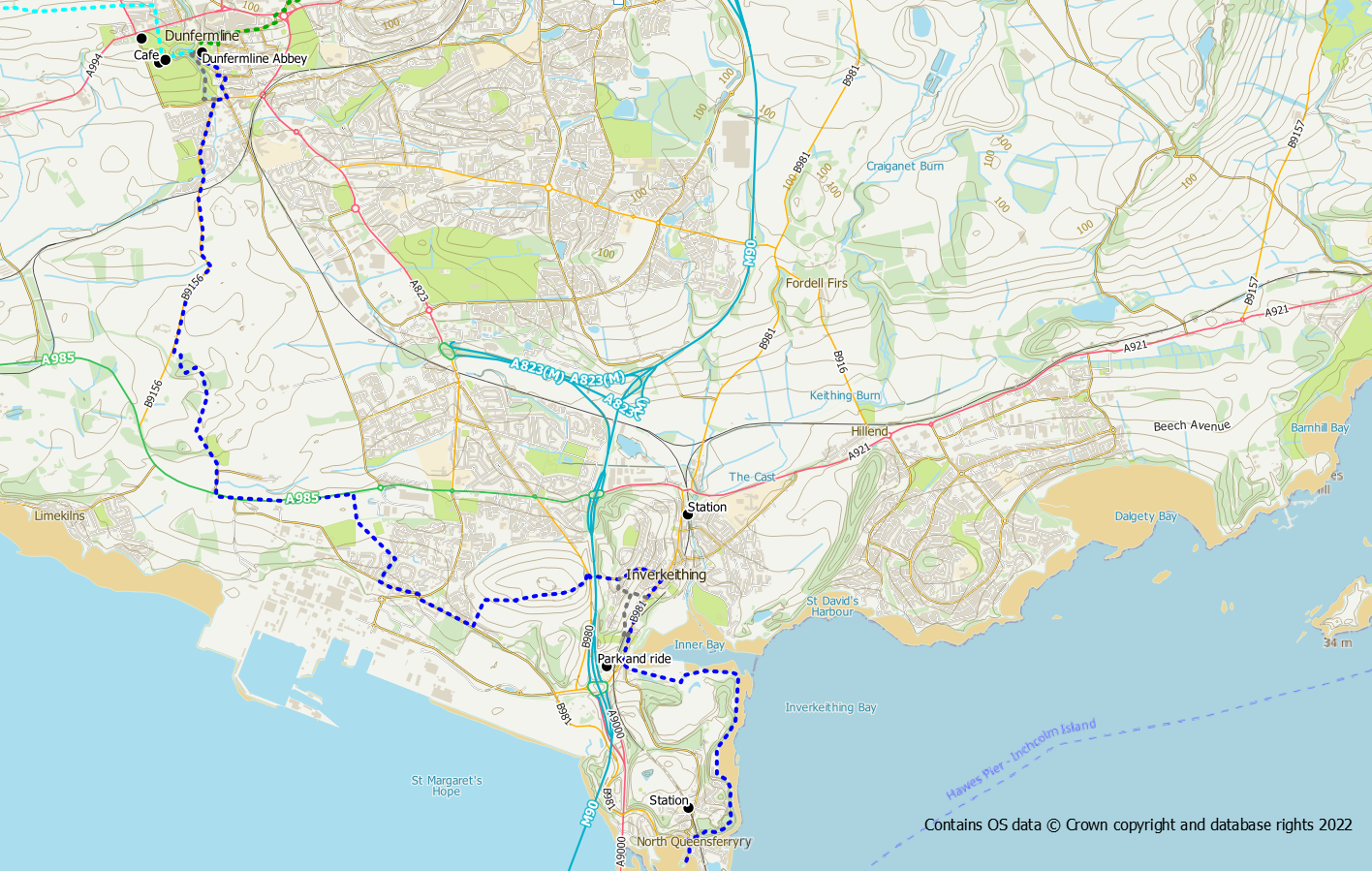
This section is primarily road walking in towns. The exception being a section of the Fife Coastal Path around Carlingnose Point and the woods at the back of Douglas Bank Cemetery.
Start from the pier at North Queensferry where the old lighthouse is worth a quick visit prior to starting the walk. The route initially follows the same route as the Fife Coastal Path up the steps at North Queensferry and around the Carling Nose nature reserve to Inverkeithing. The initial section is very pleasant but once Inverkeithing is reached you have to walk past old quarry workings and a scrap yard.
On reaching Inverkeithing turn right on to the road and walk up towards the town centre and the old Friary (Hospitium of the Grey Friars). The Civic Centre has toilets and a cafe. The FPW route then goes up the hill at the mini-roundabout via Hill Street and Dunfermline Wynd.
An alternative route to miss out some of the road walking can be taken by turning left at the cemetery. From the parking area there is a trodden path leading into grass parkland. Cross the parkland diagonally uphill to reach Manse Road from where you can make your way through the houses to Hill Street / Dunfermline Wynd.
At the top of the hill the road crosses over the motorway and reaches a junction. Take care crossing over this road and look for the FPW marker to your right marking the start of the access road up Castlandhill.
Follow the road over the hill passing old MOD sites. At the end of the road, the FPW route follows a field edge and turns left down towards Rosyth. This section over the fields can be a bit muddy at times. Once you reach the road at Rosyth, go right on the pavement for almost 1km following FPW and FCP signage. Both routes turn right into tree lined Wilson Way before bearing left around the outside of a new housing estate. The path now crosses the Fleet Grounds playing fields (ex MOD) to reach the busy A985 road.
The next section of both the FPW and FCP is 1.2km of pavement walking alongside the very busy Kincardine to Rosyth road (not a particularly enjoyable section for either route). At a junction signed for Pattiesmuir, the FPW crosses the road (take extreme care) to follow the side road for Douglas Bank Cemetery and Pattiesmuir (the FCP meanwhile goes left into the woods).
Keep to the left of the cemetery following a path with marker posts into the woods. This next, all too short, section is very pleasant though woodland and across open fields Upon reaching a track, turn right towards Wester Gellet farm where the route bears left and joins Limekilns Road. Turn right on to the road and follow the pavement with Dunfermline ahead of you. After 1.5km the road reaches a junction at the bottom Glen gates.
At this point the official route turns right along the road before turning left into Moodie Street to reach the Heritage Quarter of Dunfermline, Andrew Carnegie Birthplace Museum and the Abbey.
An alternative off- road option is to walk through the Glen (Pittencrieff Park) alongside the burn to reach the Abbey that way.
Section 2: Dunfermline to Crosshill
- Distance: 17 km / 10.5 mils
- Ascent: 200 m / 650 feet
- Terrain: Pavement/cycle route, paths (mostly surfaced)
- Facilities: Pay and Display parking in Dunfermline centre, free parking at Leys Park Road, Dunfermline, toilets and refreshments at Carnegie Library, refreshments and toilets at Lochore Meadows, on street parking at Crosshill
- Bus: Stagecoach 19
Route Map

This sections starts off along the cycle track from Dunfermline to Kingseat which is hard going on the feet. However, once past Kingseat the route becomes much more interesting.
From the Abbey the route follows Marygate, Abbot Street and Canmore Street through the old part of the town. The exhibition / museum at the Carnegie Library is worth a stop and there is a a cafe and toilets here. Turn left into Guildhall Street and then right on to the High Street. Follow the High Street along to the east where you need to use the pedestrian crossings to cross over the busy road / roundabout to reach the police station. After the police station go right into the Leys Park Road car park.
From Leys Park Road simply follow the cycle track behind the football ground and out to Whitefield Road. The route now uses the cycle track / pavement alongside the road for almost 3 km to the village of Kingseat.
About 1km of this road walk can be bypassed by walking a slightly longer route (1.1km) via Muircockhall Farm. 800m after turning right at the top of Whitefield Road, go left up the access road to the farm, turning right at the farm to follow a core path along field edges to reach Kingseat.
Once at Kingseat walk through the village to its north end.
Turn left into the access road for Loch Fitty House and Hawthorne Acres, leading down to the shore at Loch Fitty. A very pleasant walk takes you across a causeway with the sight of the St Ninian’s Land Art ahead of you. Follow the FPW signs round to the right past the farm and a small parking area. A rough landrover track leads up the east side of the site with the motorway to your right. It is well worth a detour up the spirals of the hillock with its fascinating art work on its three summits.
The landrover track emerges on to the main road near to Kelty. Cross the road and turn left and then turn right into Blairadam Forest. There is car parking and picnic tables here.
The route now picks up a forest path to your right passing through some of the more scenic bits of the forest. Follow the signs until you join a wide forest track north of the main car park. Turn right and head downhill to a cross roads where you go right following signs for Kelty. Once through the underpass under the motorway you soon reach the border and cross out of Fife and into Perth and Kinross for a short while.
Turn right onto the main road through Keltybridge and use the pavement to reach Kelty. Go left into Whitegates Terrace (opposite a shop, 200m after the junction). At the end of the road the FPW follows a track / path between a field and houses to reach a busy main road. Cross the road and turn right onto the pavement. After 300m turn left towards the Lochore Meadows car park.
From the car park the FPW follows the path into the park passing through wet land and bird hides. The official route goes clockwise around the loch following the north shore path to reach the Willie Clarke visitor centre. There is a cafe and toilets at the centre. Lochore makes a good start / finish point but if you are using the bus you will need to walk out to the road at Crosshill.
Section 3: Crosshill to Glenrothes
- Distance: 14 km / 8.7 miles
- Ascent: 200 m / 650 feet
- Terrain: Paths (some unsurfaced) and pavement walking
- Facilities: on street parking at Crosshill, free parking at Riverside Park, Glenrothes, paid parking in Glenrothes town centre, refreshments and toilets in Glenrothes town centre
- Bus: Stagecoach 81 (Glenrothes town centre not Riverside Park)
Route Map
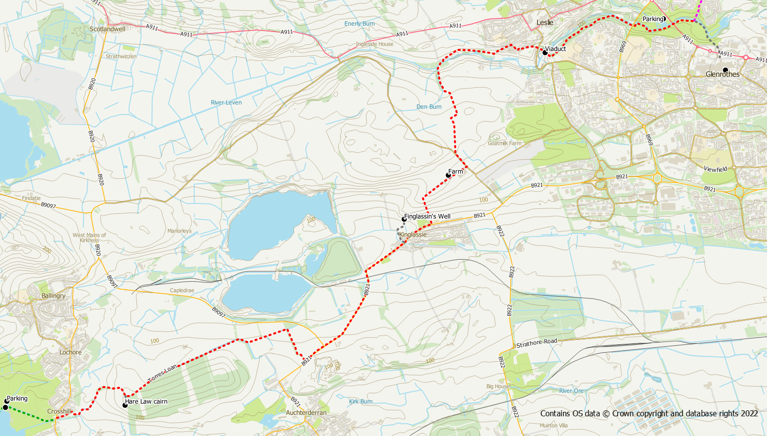
The route heads along Park Street almost opposite the entrance to the Meedies before striking off to the right on Benarty Heritage Trail signed for Harelaw Cairn and Cardenden in addition to FPW markers. From here the route is well signed across farmland firstly on unsurfaced path and later on rough farm track. A few sections can be a bit muddy. A short detour to the site of Harelaw Cairn can be made by following the signs. Beyond Redhouse Farm, the route follow the farm access road out to the main road at Woodend.
The next section is 2 miles on pavement alongside the main road into Kinglassie. Unfortunately this section is not particularly attractive or pleasant walking.
About 500m of the road can be avoided once Kinglassie is reached. On reaching the large Fife Pilgrim Way sign turn left into Redwells Road. Keep straight on with the church on your right. Pass a few houses before reaching open countryside. Bear right onto a concrete path at a core path marker post. The path crosses the outflow from Finglassin’s Well but there are paving slab steppingstones. The path becomes more of a field path and turns left to reach a marker post. At this point, turning right will take you directly to the signed Pilgrim Way route via a field path. Turning left will take you to Finglassin’s Well.
The waymarked route continues on the pavement through Kinglassie, turning left up a grassy path, beside the bowling green. Although steep it is short section and it’s a big relief to be off the road. Another detour can be made to Finglassin’s Well (again signposted). Ahead of you on the hillside is Blythe’s Tower an old lookout post, however, our route turns right on a grassy path to Finmont Farm. There are open views from this path. Beyond the farm a track leads out to the road where you turn left on to a short section of newly constructed pavement.
A path signed for Leslie and Glenrothes bears right and soon becomes a very pleasant grassy walk through shelter belt trees. The route is well signed and easy to follow. You are soon following the Den Burn and then the River Leven. The path crosses the river and you turn right following a sign for Leslie.
The route now follows a path/track between fields and a fenced off industrial area to reach the outskirts of Leslie. Keep an eye peeled for subtle markers indicating a right hand turn into a cul-de-sac. At the end of the cul-de-sac go through the gate on your left to join a path. Alternatively instead of turning into the cul-de-sac you can stay on the road for a further 50m to reach the path. Follow the markers (both FPW and a cycle path sign) along a couple of residential streets and then out on to a cycle track which takes you on to the Leslie Viaduct.
Leave the viaduct turning left at a signpost for Riverside Park to pick up a pleasant woodland path. This path path now leads all the way to Riverside Park through woodland alongside the River Leven. As you approach Glenrothes you will see the road suspension bridge in front of you.
Once under the suspension bridge simply follow the path on the south side of the river through the park. If you have time, you may also wish to explore some of the waymarked walks around the park.
To finish at the Riverside Park car park, cross to the north side of the river via a bridge before reaching the mosaic subway under the main road.
If heading for the bus, continue on the south side of the river following the FPW marker signs under the road bridge with the mosaic to reach the hippos watering hole. The FPW turns left at this point, but keep straight on to reach the colourful hippos and steps leading up to the town centre.
Section 4: Riverside Park to Kennoway
- Distance: 13 km / 8 miles
- Ascent: 150 m / 500 feet
- Terrain: Mostly paths (surfaced and unsurfaced) and pavement
- Facilities: free parking at Riverside Park, Glenrothes, paid parking in Glenrothes town centre, refreshments and toilets in Glenrothes town centre, refreshments in Markinch, free parking in Kennoway
- Bus: Stagecoach 43 (Glenrothes town centre not Riverside Park)
Route Map
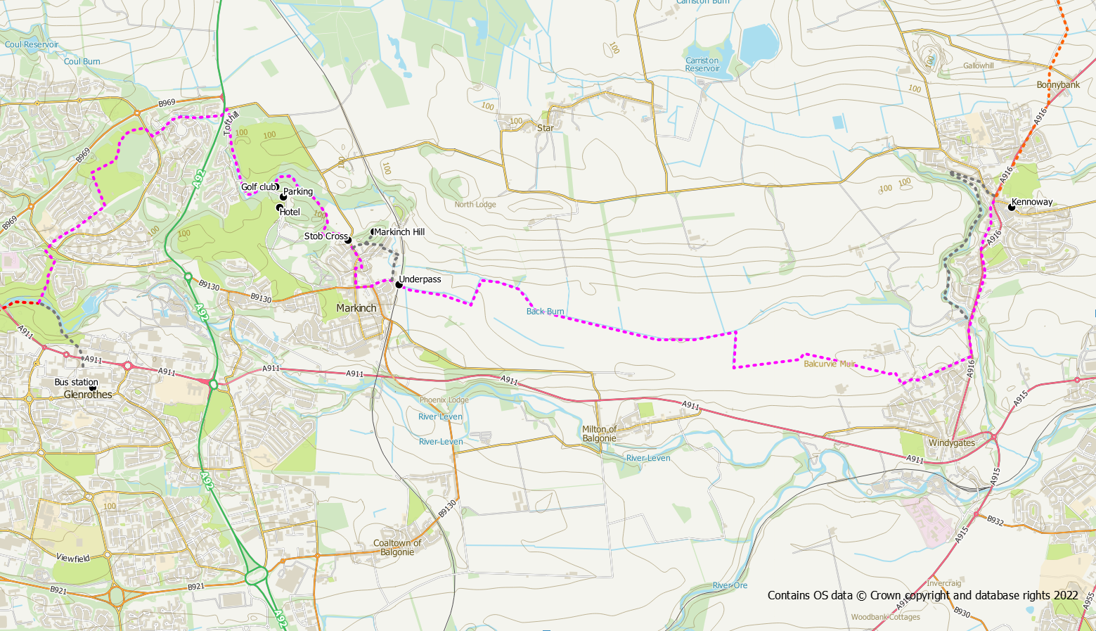
From the Riverside Park car park, cross to the south side of the river and follow the FPW marker signs under the road bridge with the mosaic. After the hippos’ watering hole the route turns left across a footbridge into the woods.
Follow the route markers on well made paths through the woods to Cadham Road which you cross by means of an underpass. There is now a bit of road walking past the schools to reach the Gilvenbank Sports Ground. Once in the sports ground turn left at waymarker post to walk round the playing fields. When you exit the sports grounds follow the waymarkers right and then left passing close to the Gilvenbank Hotel. A road walk through houses takes you close to the site of the Balfarg Henge before reaching the busy A92 road.
It is now necessary to cross this fast and busy road to reach Balbirnie Park on the opposite side. Once across the road, go left and then right through a gap in the wall to enter the park. The route through the park is clearly waymarked. You will pass the relocated stones from the Balfarg Henge followed by a pleasant woodland walk to reach the club house. Turn left here following the waymarker post to reach a path on the far side of the car park. The route now follows the Balbirnie Burn before emerging out of the park onto Stobcross Road.
Turn right to walk on the pavement into Markinch, passing the Stob Cross, and follow the waymarkers through the town. The route is somewhat convoluted as it does a loop along the main streets of the town, so follow the waymarkers carefully. Turn into Brunton Road and follow it to its end where it passes under a railway arch and becomes a farm track.
An alternative, more walker friendly, route through Markinch is to head over Markinch Hill instead of through the town. After passing the Stob Cross, turn left through a gate on to a surfaced path over a grassy hillside. If you want to visit the Markinch Hill viewpoint with its information panels you will need to detour left up grassy paths. The main path brings you out on Northall Road where almost immediately opposite is a lane with houses. Go up the lane and, after the houses but before reaching the railway arch, go right through a wooden kissing gate on to a wooded path. The path soon reaches another quiet lane which brings you back on to the FPW route close to the Brunton Road railway arch.
The next 3 miles are over farmland between Markinch and Balcurvie. Initially this is on a surfaced path but soon becomes a field edge track which could be muddy after heavy rain. Some of the route is alongside open fields so please keep dogs under control and on the path. Keep an eye out at junctions for the waymarker posts as you need to make a left turn and then keep straight on at a point where the main track goes left. At a stone bridge the route turns right (south) before turning left (east) to continue past fields to reach Balcurvie. A short road section now follows to reach the main road.
Turn left and walk along the pavement at the side of the road. The remainder of the route into Kennoway follows roads, initially the main road that you are currently on followed by The Causeway back road through older cottages, to reach the town centre.
An alternative non-road route however, can be followed by taking the path/track signed for Kennoway Den on your left and following the path alongside the river. Keep to the main path until you cross the river and reach a grassy area with a totem pole. Turn right either up steps or the “ramp” next to the totem pole to reach a road and then turn right for the centre of Kennoway.
Section 5: Kennoway to Ceres
- Distance: 13.5 km / 8.5 miles
- Ascent: 230 m / 750 feet
- Terrain: some pavement/quiet road but mostly tracks and paths
- Facilities: free parking in Kennoway, free parking in Ceres, refreshments and toilets in Ceres
- Bus: Stagecoach 41 (this service may be withdrawn in the near future and replaced with a different one)
Route Map

This is a particularly pleasant section of the route as once you leave Kennoway there is no more town walking until you reach Ceres. Road walking is also at a minimum on this part of the route.
The route heads north out of Kennoway on pavement to Bonnybank. Turn left up a track at the back of the houses before you enter the village. The track soon crosses a quiet road and continues through farmland and later forest to reach Devon Wood. All junctions on this section are well waymarked and the route is easy to follow. When you reach the main forest track through Devon Wood you are rewarded with open views to the Lomond Hills. Trees have been felled here and are currently being replanted.
The track enters unfelled forest for a section of typical forest walking to reach Clatto Farm. The highest point along this stretch, the slopes of Clatto Hill at almost 230m, is also the highest point of the Fife Pilgrim Way. If you don’t mind dealing with fallen trees and rough ground, you could make a detour up a trodden path to the 248m summit of Clatto Hill though, due to the forestry, there are no views from here. On reaching Clatto Farm, the FPW path goes round the outside of the farm through a couple of gates. This section may be very muddy if cattle have been grazing on the path. Beyond the farm is a steep downhill section followed by a newly constructed path section to Clatto Reservoir. This new path is probably the only section of the Fife Pilgrim Way that does not make use of pre-existing routes.
Clatto Reservoir and Nature Reserve is a little gem and makes a good coffee / lunch stop. After leaving the reservoir there is a section of road walking on the access road and a quiet country road. At Little Muirhead Farm a waymarker points left into the field where the route now follows a pathless field edge for 1.4km. This route across the fields is part of the old road between Kennoway and Ceres. Again the route is well signposted and easy to follow across the fields to reach the A916 road.
Take extreme care and cross over the road to reach the start of the Waterless Road opposite. This old right of way makes for a very pleasant (though it may be muddy after heavy rain) final 2.5km across farmland to reach the village of Ceres. There is a cafe and toilets at the Folk Museum in Ceres.
Section 6: Ceres to St Andrews
- Distance: 15. 5 km / 9.5 miles
- Ascent: 180 m / 600 feet
- Terrain: Mostly surfaced paths, some unsurfaced path and pavements
- Facilities: free parking in Ceres, refreshments and toilets in Ceres, toilets and refreshments at Craigtoun Park, toilets and refreshments in St Andrews, paid parking in St Andrews
- Bus: Moffat and Williamson 64
Route Map

From the Ceres car park cross over the stone bridge and follow the waymarkers to exit the village on the path to Callange. For 1.6km the path crosses farmland with an open outlook across fields and back to Ceres. Keep an eye out for the route turning left off the path along a grassy field edge for almost 600. Turn right onto another path to reach a public road.
Slightly left and opposite is a path signed for Ladeddie. Follow this path past Kinninmounth Farm and over Kinninmounth Hill to reach the road at Ladeddie. There are good views along this section stretching as far north as the Southern Cairngorms on a good day.
When you reach Ladeddie you have 3.75 km of road walking ahead of you. The road is relatively quiet although it does get a bit of use and once past the junction at Drumcarrow Craig the traffic does noticeably increase. As there is no pavement it would be wise to walk this section in single file on the right hand side of the road (so that you are facing the oncoming traffic). Keep right at Denhead Farm and walk through Denhead Village.
About 350m beyond the village the route turns right into woodland on a path signed for Craigtoun Park. The next section through the woods is a delight after the slog of road walking. Keep following the path with the waymarkers to reach the golf course and Craigtoun Park. There are picnic benches, the golf club, toilets and a cafe at the park.
The route is signed by waymarkers through the park and takes you through gardens to reach Craigtoun Den. From now onwards we will be following the burn all the way into St Andrews mostly through wooded areas.
After crossing a road, Craigtoun Den becomes Lumbo Den and then Lade Braes. Keep an eye out for waymarkers to ensure you cross the river and follow the path down into St Andrews. After passing the Botanics you reach the grassy Cockshaugh Park. Beyond the park the route uses a short section of back road to reach Argyle Street.
Turn right along Argyle Street and go through the West Port on to South Street. There are now plenty of cafes and bars if you need refreshment. However, it is only 750m along South Street to its eastern end where you turn left to be greeted by the site of St Andrews Cathedral and your journey’s end.
