Hills: Redwells Hill (192m), East Goatmilk Hill (172m), West Goatmilk Hill (163m), Hill of Kirkforthar (157m), Hare Law (149m), Keir Brae (139m), Balgreggie Craigs (138m), Dalginch Hill (137m) / Cuinin Hill.
A selection of other Central Fife hills not covered elsewhere. Generally these hills will be more of interest to the “hill bagger” rather than the casual walker. Most of these hills either lie on, or are accessed from, working countryside (farming, shooting etc) so ensure you follow the Scottish Outdoor Access Code.
Map
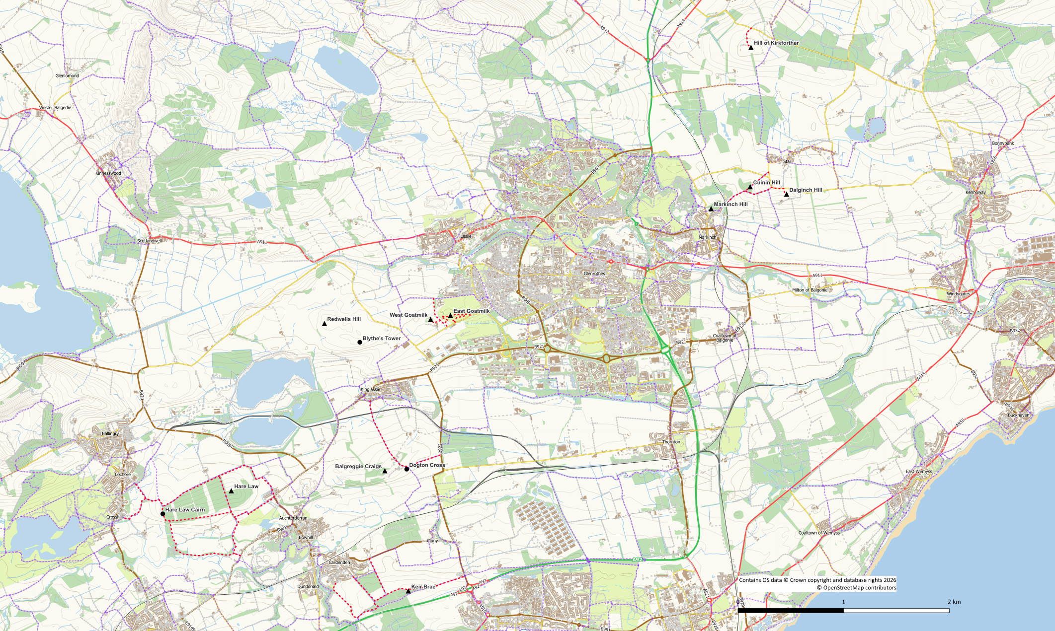
Redwells Hill (192m)
The easiest approach to this hill is from the minor road to the east although parking is not easy. Keep to the north of the reservoirs and follow field edges to the summit trig point with Blyth’s Tower to your left. The fences and walls are well supplied with gates but take care to follow the Scottish Outdoor Access Code as this is working farmland. If you wish to visit the tower the best approach is from the west otherwise it is protected by barb wire, electric fences and gorse!
Hill of Kirkforthar (157m)
This hill is the high point of an arable field and may not be accessible at some times of the year. If there are crops in the field, come back at another time! There was a trig pillar at the summit until fairly recently but this has now been moved and is lying on its side. There is a road/track (probably private though) up to Hilton of Forthar from where there is access to the field. The area is for sale and is likely to be developed in the future so access may change.
Hare Law (149m)
The area of Torres Loan across the artificial hill of Hare Law from Crosshill to Auchterderran is relatively pleasant for a short walk. Torres Loan itself now forms part of the Fife Pilgrim Way and provides easy access to the summit of Hare Law. There are two reasonable approaches to the actual summit of Hare Law at its eastern end. Firstly by leaving Torres Loan via a gate into a pasture field at NT 2000 9690. Alternatively, there is a rough path through woodland that leaves the main path network at NT 2003 9651.
The paths around this area are worth exploring for a short walk and the the prehistoric burial chamber of Hare Law Cairn lies at the western end of the hill. There is easy access to the paths from both the Crosshill and Auchterderran sides.
Keir Brae (139.4m)
Not a hill to get excited about as it is simply the high point in the rough brash to the south of the path through Sunnyside Plantation near Cardenden. The woodlands in the area do however, provide options for pleasant walks. The summit and trig pillar are not co-located being about 200 – 250m along the track from each other.
Balgreggie Craigs (138m)
This hill can be reached via a straightforward walk along a core path from Kinglassie to Pitlochie. From the farm a track can be followed up to the masts from where a trodden path leads into the woods and up to the higher ground. Whilst in the area it also worthwhile visiting the Dogton Stone Pictish cross. An alternative access route is via a track from the B922.
Dalginch Hill (137.5m) / Cuinin Hill
Dalginch hill, to the north-east of Markinch has two summits both shown as 138m on the current OS maps (2021). However recent analysis has revealed that the eastern summit measured at 137.5m is the high point. The two summits, and the trig pillar in between them, can be accessed either from the north or the south. The southern approach has a “private” sign on approach to the cottages so if you want to avoid any possible confrontation the approach from the north may be better. Leave the road at NO 31176 02600 through a broken section of wooden fencing and head up to the grassy coll between the summits. From the south it is also a short walk starting from behind the garages at the cottages.
Cuinin Hill has a height of 137m on the current maps and is well worth a walk in its own right. A path from Northall goes up the hill through the woodland passing close to the summit.
East Goatmilk (171.6m) and West Goatmilk (163.4m)
These two wooded hillocks are located across the road from Fife Airport and adjacent to Glenrothes Golf Course
There are three reasonably straightforward approaches to the hills.
Opposite the airport (slightly west of the entrance) is the start of a short track to a ruined building. From here East Goatmilk can be ascended by means of steep-ish mountain bike trails leading up to the summit ridge. A trodden path leads across the ridge from west to east. The high point of the hill has an Ordnance Survey trig point bolt embedded in a flat rock. West Goatmilk is best reached by returning to the ruin as a direct route is awkward due to vegetation on the steep hillside and a barbwire fence. South of the ruin is a section of wooden fencing where the barbwire fence can easily be climbed. The barbwire has been removed from this bit. Once over the fence head across the rough pasture to the back of the barn at Goatmilk Farm where a convenient gate gets you through the next barbwire fence. From here it is a straightforward to avoid the gorse and reach the hill summit.
An alternative approach from the south is by means of the golf course. There are a couple of gates onto the golf course from the airport road east of the hill. Walk round the edge of the golf course aiming uphill (take care to keep an eye out for golfers) until you reach a concrete water tank. At the side of the structure is the start of the trodden path across the summit ridge. Although overgrown at the start it very soon improves and becomes an obvious path to the summit. To reach West Goatmilk continue along the path turning left downhill at an obvious junction (avoid going back on to the golf course) on the mountain bike trails described above.
From the north there is easy enough access into the rough pasture field that lies between the hills. The Bloodyfoot core path links the Fife Pilgrim Way to Glenrothes. Close to the Newcastle residential area is an open gateway. Skirt the edge of the woodland (on your left) and then cross the rough pasture field described above and aim either right (on a track) towards the gate at the back of Goatmilk Farm or follow the edge of the fence around the Goatmilk Hill woods to the ruin and the wooden section of fence if heading for Goatmilk East.
