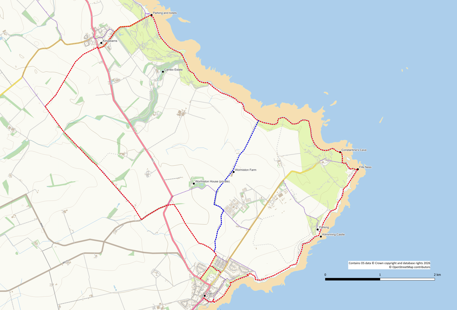
Crail and Fife Ness Circuit
A circular walk on the Fife Coastal Path around the easternmost point of Fife. Outward route from Crail is on the coastal path whilst the return route makes use of a disused railway line.
A shorter option is available by walking from Crail around Fife Ness and returning via Wormiston
- Full route distance: 16.3 km / 10.1 miles
- Shorter route distance: 10 km / 6.2 miles
- Full route ascent: 130 m / 420 feet
- Shorter route ascent: 100m / 300 feet
- Terrain: Mostly unsurfaced and uneven paths. Some hard surface walking at Kingsbarns
- Start / finish: Crail. Both routes could also be started from Kilminning or Fife Ness. The full route could be started at Kingsbarns
Route Map
Start from the centre of Crail where there is plenty of parking available. The quickest route to the coastal path is down Castle Street next to the pharmacy and keeping to the left of Crail House. However, you may prefer to walk down to the picturesque harbour and follow the coastal path along the front of Crail House. Whichever way you choose, you want to end up on the coastal path heading away from Crail past a play area. Beyond here the path then loops around Roome Bay before entering a caravan site.
Use the Coastal Path route through the caravan site and into Kilminning Nature Reserve. This is a particularly attractive section of the walk dominated by the rock feature of “Kilmming Castle”. Beyond the “castle” is a car park and picnic area which can be used as an alternative start point for this walk. The area inland is the site of the old HMS Jackdaw airfield and now the location of Crail Raceway.
Continuing along the coast the next notable feature is Danes Dike a grass covered banking that once surrounded Fife Ness. Fife Ness is the eastern most promontory of Fife seperating the Forth and Tay. Once home to a coastguard station, it still houses a functioning lighthouse. As you follow the path around the coast you will pass an intriguing circle cut in the rocks on the right. This was used as a template by Robert Stevenson when building a beacon out on the treacherous Carr Rocks. This was later replaced by a series of light vessels and, in the 1970’s, the current Fife Ness lighthouse.
The next point of interest is the site of a tidal mill where the ebb and flood of the tide would have been used to turn the mill wheel. An information board is still in place here. The coastal path route now follows the edge of the golf course marked by a line of white posts. Take care whilst walking through this area. Pass Constantine’s Cave. Legend has it that Constantine II was killed here by the Danes. The cave has long associations with Christianity and contains carvings of crosses and animals.
The route continues on around the golf course with a low tide beach alternative being an option. Take great care walking around the golf course.
At the far edge of the golf course is the option to head inland away from the coast for the shorter option. The promontory in front of you (which the full route path partially climbs) is the site of Randerston Castle hillfort though there are no visible remains.
Crail and Fife Ness full route
Continue along the coast now passing around farmland. Note that cattle may sometimes be grazing on these grassy fields. promo
Cross over the stone stile to reach the next golf course and follow the path around its edge. The trees ahead of you form part of the Cambo Estate Woodlands, famed for its snowdrops. As you enter the trees you will cross the Cambo Burn and marker posts guide you to the next golf course. Here there are toilets for the golfers but there is no sign saying others cannot use them and they are not locked.
You can now either walk on the path around the edge of the golf course or walk along the beach to reach the popular Kingsbarns Beach car park. During Summer months there are toilets and a fast food outlet here.
From the car park walk up the tarmac road for just over 1km to the main road through the village. Cross over the road and follow the farm track that is almost immediately opposite (offset slightly to the right). After about 850m you reach a band of trees and the farm track follows a field edge. At the next fence go straight on through the gap in the fence to follow the track alongside a wall.
When you reach the route of the old Anstruther St Andrews railway line at a signpost, turn left. Initially the railway line is rather overgrown but it soon improves and becomes a good track. After about 1.4km the shorter route joins from the left at an area with metal gates and fences.
Continue on the railway for a further 1.2km, passing a couple of houses, until you emerge on to the B9171 road. Turn left and follow the road for 500m to its junction with the A917.
Cross over the main road to reach the unsurfaced path opposite with a purple arrow marker. This next section of path can be somewhat overgrown but follow it as it swings round to the right and follows a field edge to reach a caravan park where the path improves. Turn right at this point passing behind some houses to reach a cemetery. After the cemetery follow the path to a church where you turn left on to the main road to head back to the centre of Crail.
Crail and Fife Ness shorter route
Leave the coastal path using a grassy trodden path up the hillside with the golf course on your left. At the top of the hill the start (or end) of a farm track is reached. Follow this track inland past a row of cottages on your right and Wormiston farm on your left. This section of the walk is through unfenced arable fields. Keep to the track and don’t permit dogs to stray into the fields. 350m beyond the farm the now surfaced road bears right at a junction. However, keep left through a gate onto a rough track again crossing arable fields. On reaching a silo turn onto a field path marked with a core path indicator post. From here it is a straightforward walk back to Crail. Keep right at a path junction so that you head pass the cemetery extension and towards the church.
References / Further Reading
Fife Ness Lighthouse: https://portal.historicenvironment.scot/apex/f?p=1505:300:::::VIEWTYPE,VIEWREF:designation,LB52557
Danes Dyke: https://www.trove.scot/place/35355#details
Kilminning Nature Reserve: https://aboutcrail.wordpress.com/kilminning/
Constantine’s Cave: https://www.trove.scot/place/35369#details
Randerston Castle Hillfort: https://hillforts.arch.ox.ac.uk/records/SC3174.html
Fife Coastal Path: https://fifecoastandcountrysidetrust.co.uk/walks/fife-coastal-path/
Crail Information: https://www.crail.info/
