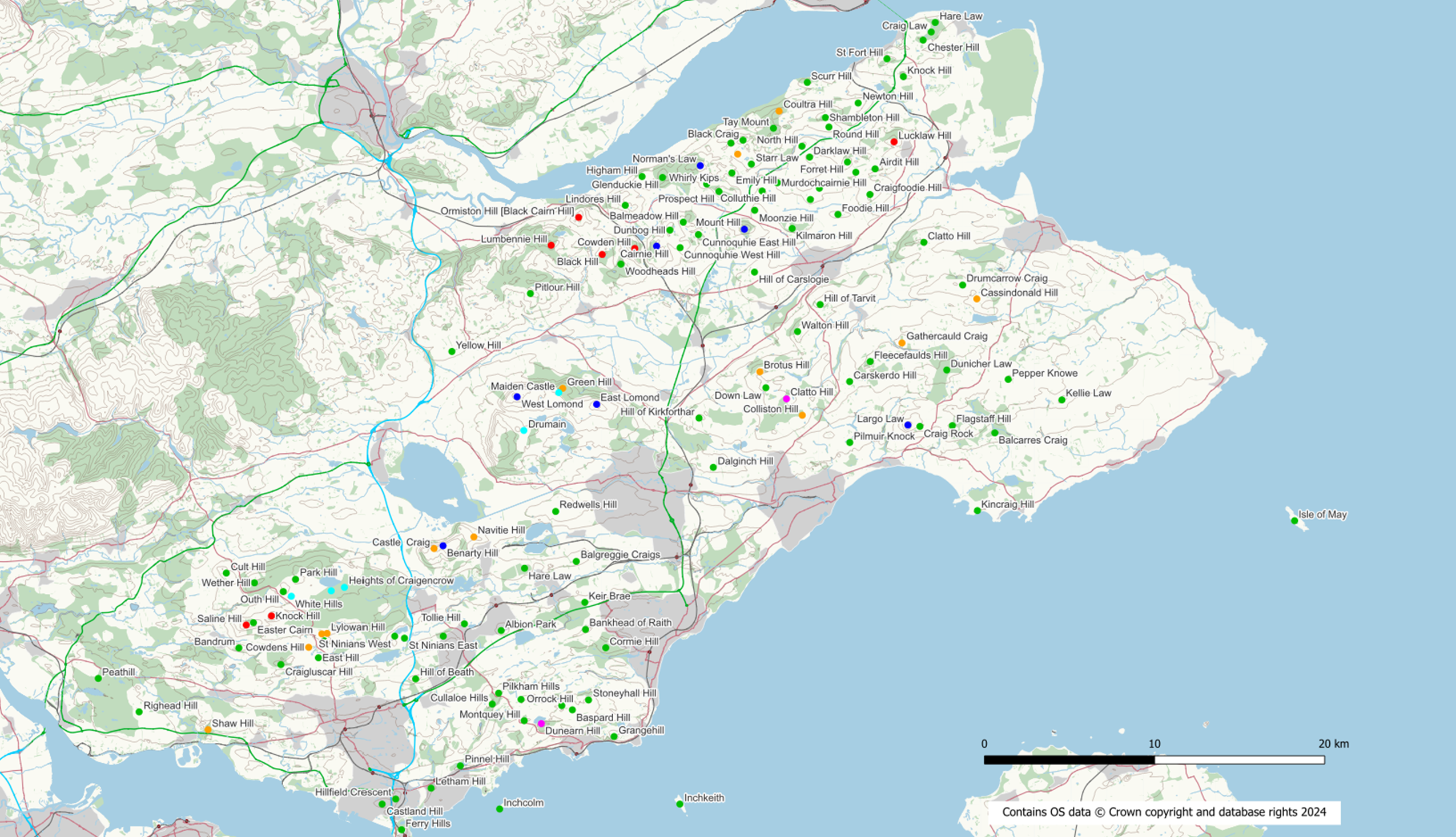
The following list includes those “hills” that are included in the Marilyn, Humps, Tumps, Sub-Tumps and TumpBeag lists. If a hill is not listed here either it is not in Fife or it does not appear in one of the lists.
| Name | Height(m) | Drop(m) | Grid Ref | Classification | Feature |
| West Lomond | 522 | 405 | NO1973106639 | Marilyn | trig point |
| East Lomond | 448 | 155 | NO2440906194 | Marilyn | no feature: ground 5m S of viewpoint |
| Knock Hill | 364 | 112 | NT0534993761 | Hump | ground 2m SW of trig point |
| Saline Hill | 359 | 104 | NT0386393227 | Hump | cairn |
| Benarty Hill | 356 | 228 | NT1538097881 | Marilyn | trig point |
| Easter Cairn | 355 | 32 | NT0428693362 | Tump | no feature |
| Castle Craig | 346.59 | 27.65 | NT1485297720 | Sub Tump | |
| Drumain | 343.45 | 16.65 | NO2012804660 | TumpBeag | |
| Park Hill | 339 | 33 | NT0676195910 | Tump | embedded rock |
| Wether Hill | 335 | 61 | NT0434395706 | Tump | grassy knoll |
| Outh Hill | 324 | 36 | NT0604395188 | Tump | grassy dyke |
| Green Hill | 313.49 | 21.52 | NO2241407138 | Sub Tump | |
| Maiden Castle | 313.01 | 19.22 | NO2218406884 | TumpBeag | |
| White Hills | 310.1 | 17.49 | NT0651494916 | TumpBeag | |
| Kings-seat Knowe | 304.1 | 18.5 | NT0886095234 | TumpBeag | |
| Heights of Craigencrow | 296.5 | 16.6 | NT0963495438 | TumpBeag | |
| Largo Law | 290 | 196 | NO4270704979 | Marilyn | trig point |
| Norman’s Law | 285 | 209 | NO3050220222 | Marilyn | windshelter 5m N of trig point |
| Lumbennie Hill | 284 | 139 | NO2173515542 | Hump | trig point |
| Pitlour Hill | 275 | 53 | NO2051412708 | Tump | no feature |
| Cult Hill | 264 | 63 | NT0269196278 | Tump | trig point |
| Clatto Hill | 248 | 91 | NO3557106516 | Sub Hump | trig point |
| Roscobie Hills | 246.1 | 25.1 | NT0830692704 | Sub Tump | |
| Lathalmond Hill | 245 | 37 | NT0844592298 | Tump | no feature: spoil at SW end of quarry |
| Navitie Hill | 243.76 | 24.01 | NT1719298400 | Sub Tump | |
| Lylowan Hill | 241.4 | 20.7 | NT0861692732 | Sub Tump | |
| Down Law | 241 | 34 | NO3435607171 | Tump | no feature |
| Hill of Beath | 240 | 82 | NT1376990058 | Tump | ground by trig point |
| Dunicher Law | 240 | 73 | NO4499008211 | Tump | artificial mound of stones |
| Ormiston Hill [Black Cairn Hill] | 236 | 103 | NO2335017185 | Hump | large cairn |
| Craig Rock | 235 | 31 | NO4341204898 | Tump | no feature |
| Cairnie Hill | 228.9 | 150.4 | NO2793215493 | Marilyn | embedded boulder in grass |
| Craigluscar Hill | 228 | 41 | NT0590090900 | Tump | |
| Bandrum | 225 | 43 | NT0343091879 | Tump | ground by tree |
| Dunearn Hill | 223.6 | 98.7 | NT2115887433 | Sub Hump | knoll at clifftop |
| Mount Hill | 222 | 164 | NO3309416486 | Marilyn | no feature: ground on NW side of tower 25m WSW of trig point |
| Cullaloe Hills | 219 | 82 | NT1827188579 | Tump | no feature |
| Glenduckie Hill | 218 | 85 | NO2828019527 | Tump | no feature |
| Drumcarrow Craig | 218 | 74 | NO4592513205 | Tump | large cairn W of trig point |
| Brotus Hill | 216.3 | 25.1 | NO3400408106 | Sub Tump | |
| Dunbog Hill | 216 | 54 | NO2871316434 | Tump | ground by trig point |
| Flagstaff Hill | 214 | 43 | NO4531904942 | Tump | huge grassy mound |
| Black Hill | 213 | 104 | NO2473415003 | Hump | no feature |
| Pepper Knowe | 212 | 39 | NO4860107661 | Tump | ground 3m N of trig point |
| Fleecefaulds Hill | 212 | 34 | NO4049008712 | Tump | no feature: woodland |
| Hill of Tarvit | 211 | 88 | NO3754712060 | Tump | ground at SE corner of monument |
| East Hill | 209 | 37 | NT0810991300 | Tump | no feature |
| Cowdens Hill | 207.5 | 21.6 | NT0753491914 | Sub Tump | |
| Orrock Hill | 205 | 49 | NT2236188486 | Tump | trig point |
| Cowden Hill | 204 | 112 | NO2665115359 | Hump | cairn |
| Black Craig | 203 | 73 | NO3301121720 | Tump | outcrop |
| Carskerdo Hill | 202 | 39 | NO3928107532 | Tump | no feature |
| Yellow Hill | 200 | 33 | NO1590009300 | Tump | |
| Colliston Hill | 199.28 | 28.33 | NO3649805552 | Sub Tump | |
| Cunnoquhie West Hill | 199 | 36 | NO2931615402 | Tump | no feature: ground c 20m SE of mast |
| Baspard Hill | 197 | 38 | NT2298288239 | Tump | no feature |
| Balmeadow Hill | 196 | 45 | NO2950016900 | Tump | |
| Woodheads Hill | 196 | 43 | NO2583514438 | Tump | no feature: ground 15m W of trig point |
| Pilkham Hills | 194 | 32 | NT1864689220 | Tump | no feature: ground near old wall |
| Stoneyhall Hill | 194 | 31 | NT2393288819 | Tump | no feature: pasture E of building |
| Redwells Hill | 192 | 75 | NT2200099900 | Tump | |
| Lucklaw Hill | 190 | 117 | NO4189321623 | Hump | cairn 7m SSW of trig point |
| Gathercauld Craig | 189.94 | 24.07 | NO4235809802 | Sub Tump | |
| Green Craig | 189 | 43 | NO3230221549 | Tump | no feature |
| Tay Mount | 189 | 42 | NO3480222423 | Tump | no feature: ground 18m SE of trig point |
| Walton Hill | 188 | 60 | NO3622010471 | Tump | no feature: pasture |
| Prospect Hill | 188 | 56 | NO3160018700 | Tump | |
| Kellie Law | 184 | 46 | NO5176006456 | Tump | mound 15m E of trig point |
| St Ninians East | 181 | 49 | NT1311392452 | Tump | no feature: ground on E top |
| Craigbeath Hill | 181 | 30 | NT1539392569 | Tump | no feature: ground in small clearing |
| Lindores Hill | 178 | 65 | NO2609317892 | Tump | ground on NE side of fence |
| Coultra Hill | 178 | 29 | NO3513323428 | Sub Tump | no feature: ground near large rock |
| Myrecairnie Hill | 173 | 62 | NO3697318234 | Tump | trig point |
| Forret Hill | 173 | 57 | NO3915420434 | Tump | pile of stones |
| Cassindonald Hill | 173 | 20.1 | NO4675612392 | Sub Tump | |
| St Ninians West | 170 | 32 | NT1253992570 | Tump | no feature |
| Craigfoodie Hill | 169 | 52 | NO4047418527 | Tump | ground by remains of old wall |
| Albion Park | 169 | 36 | NT1880092900 | Tump | |
| Clatto Hill | 168 | 56 | NO4364315716 | Tump | no feature: ground c 20m SE of trig point |
| Templehall Hill | 167 | 38 | NT1996488852 | Tump | no feature: pasture |
| Whirly Kips | 167 | 30 | NO3087719141 | Tump | no feature: pasture |
| Starr Law | 164 | 41 | NO3350520315 | Tump | no feature: woodland |
| Montquey Hill | 164 | 39 | NT2015187601 | Tump | no feature |
| Bankhead of Raith | 164 | 36 | NT2375492962 | Tump | no feature: ground on track |
| Kedlock Hill | 163 | 44 | NO3750318897 | Tump | heap |
| Airdit Hill | 162 | 39 | NO4077820035 | Tump | no feature: ground on quarry edge |
| Tollie Hill | 159 | 33 | NT1663893296 | Tump | no feature: pasture |
| Craigsanquhar | 159 | 31 | NO3964519835 | Tump | no feature: grass |
| Cormie Hill | 158 | 48 | NT2494491888 | Tump | knoll 10m W of tower |
| Murdochcairnie Hill | 157 | 53 | NO3503619218 | Tump | ground by tree |
| Hill of Kirkforthar | 157 | 35 | NO3042705387 | Tump | no feature: arable |
| Foodie Hill | 156 | 67 | NO3859317356 | Tump | knoll |
| Higham Hill | 155 | 39 | NO2708119581 | Tump | standing stone |
| Emily Hill | 154 | 32 | NO3236019794 | Tump | no feature: pasture |
| Brunton Hill | 153 | 29 | NO3270020900 | Sub Tump | |
| Cunnoquhie East Hill | 151 | 37 | NO3039016169 | Tump | no feature: ground by track |
| Darklaw Hill | 150 | 47 | NO3692820726 | Tump | no feature: ground by gorse bush |
| Hare Law | 149 | 46 | NT2017196563 | Tump | ground by fence |
| Kilmaron Hill | 147 | 57 | NO3590116533 | Tump | knoll |
| Newton Hill | 144 | 41 | NO3978223902 | Tump | no feature: pasture |
| Keir Brae | 139.4 | 30.7 | NT2371394559 | Tump | no feature: ground on S side of track |
| Moonzie Hill | 138 | 37 | NO3370017600 | Tump | |
| Balgreggie Craigs | 138 | 37 | NT2321196962 | Tump | ground by wall |
| Dalginch Hill | 137.5 | 44 | NO3126502491 | Tump | no feature |
| Shambleton Hill | 134 | 35 | NO3785923047 | Tump | no feature: ground by fence on S side of track |
| Colluthie Hill | 130 | 41 | NO3413718732 | Tump | embedded rock |
| St Fort Hill | 123 | 89 | NO4147726502 | Tump | mossy boulder in woodland |
| North Hill | 123 | 55 | NO3647921366 | Tump | no feature: pasture |
| Balcarres Craig | 123 | 31 | NO4781604516 | Tump | no feature: ground by ruined wall |
| Grangehill | 118 | 38 | NT2543386671 | Tump | no feature: pasture |
| Hare Law | 112 | 61 | NO4431028638 | Tump | ground by tower |
| Craig Law | 111 | 44 | NO4407728079 | Tump | no feature |
| Chester Hill | 107 | 33 | NO4360027600 | Tump | |
| Round Hill | 106 | 39 | NO3806322493 | Tump | no feature |
| Scurr Hill | 104 | 43 | NO3679125114 | Tump | covered boulder pile by tree |
| Peathill | 103 | 57 | NS9516490087 | Tump | ground by track |
| Pilmuir Knock | 100 | 33 | NO3929103952 | Tump | no feature |
| Letham Hill | 95 | 60 | NT1467983636 | Tump | no feature: ground by track |
| Righead Hill | 95 | 36 | NS9756788120 | Tump | trig point |
| Knock Hill | 91 | 47 | NO4244125454 | Tump | small cairn |
| Hill of Carslogie | 87 | 41 | NO3368813967 | Tump | no feature: pasture |
| Castland Hill | 85 | 52 | NT1180082700 | Tump | |
| Shaw Hill | 84.07 | 27.11 | NT0161887074 | Sub Tump | |
| Pinnel Hill | 82 | 44 | NT1639684947 | Tump | cairn |
| Hillfield Crescent | 77.7 | 33.9 | NT1259782999 | Tump | no feature: grass |
| Ferry Hills | 71 | 54 | NT1294381193 | Tump | ground W of covered reservoir |
| Kincraig Hill | 65 | 49 | NT4679299949 | Tump | raised ground surrounding ruined building near trig point |
| Inchkeith | 59 | 59 | NT2930082700 | Tump | |
| Isle of May | 51 | 51 | NT6543899354 | Tump | no feature |
| Inchcolm | 31.5 | 31.5 | NT1870882412 | Tump | ground by mast |
Hill data taken from:
Database of British and Irish Hills https://www.hills-database.co.uk/
Haroldstreet https://www.haroldstreet.org.uk/
Please note that information on this page may not be as up to date as that contained within the excel spreadsheet.
