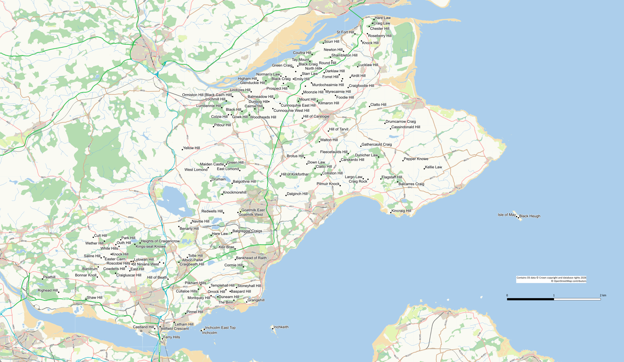
The following list includes those “hills” that are included in the Marilyn, Humps, Tumps, Sub-Tumps and TumpBeag lists. If a hill is not listed here either it is not in Fife or it does not appear in one of the lists. There are often updates to the Sub Tumps and Tump Beags (both of which are “incomplete” lists) and there may be a delay before changes are posted here.
Hills for which there is a write-up on this site appear in the menu on the previous page. This includes hills such as the Burntisland Binn and Bonnar Knowe which are not currently in any of the lists.
| Name | Height(m) | Drop(m) | Grid Ref | Classification | Feature |
| West Lomond | 522 | 405 | NO1973106639 | Marilyn | trig point |
| East Lomond | 448 | 155 | NO2440906194 | Marilyn | no feature: ground 5m S of viewpoint |
| Knock Hill | 364 | 112 | NT0534993761 | Hump | ground 2m SW of trig point |
| Saline Hill | 359 | 104 | NT0386393227 | Hump | cairn |
| Benarty Hill | 356 | 228 | NT1538097881 | Marilyn | trig point |
| Easter Cairn | 355 | 32 | NT0428693362 | Tump | no feature |
| Drumain | 343.45 | 16.65 | NO2012804660 | TumpBeag | |
| Park Hill | 339 | 33 | NT0676195910 | Tump | embedded rock |
| Wether Hill | 335 | 61 | NT0434395706 | Tump | grassy knoll |
| Outh Hill | 324 | 36 | NT0604395188 | Tump | grassy dyke |
| Green Hill | 313.49 | 21.52 | NO2241407138 | Sub Tump | |
| Maiden Castle | 313.01 | 19.22 | NO2218406884 | TumpBeag | |
| White Hills | 310.1 | 17.49 | NT0651494916 | TumpBeag | |
| Kings-seat Knowe | 304.1 | 18.5 | NT0886095234 | TumpBeag | |
| Heights of Craigencrow | 296.5 | 16.6 | NT0963495438 | TumpBeag | |
| Largo Law | 290 | 196 | NO4270704979 | Marilyn | trig point |
| Norman’s Law | 285 | 209 | NO3050220222 | Marilyn | windshelter 5m N of trig point |
| Lumbennie Hill | 284 | 139 | NO2173515542 | Hump | trig point |
| Pitlour Hill | 275 | 53 | NO2051412708 | Tump | no feature |
| Balgothrie Hill | 273.6 | 23.6 | NO2328204292 | Sub Tump | |
| Knockmorehill/td> | 266.7 | 23.8 | NO2180002676 | Sub Tump | |
| Cult Hill | 264 | 63 | NT0269196278 | Tump | trig point |
| Clatto Hill | 248 | 91 | NO3557106516 | Sub Hump | trig point |
| Roscobie Hills | 246.1 | 25.1 | NT0830692704 | Sub Tump | |
| Lathalmond Hill | 245 | 37 | NT0844592298 | Tump | no feature: spoil at SW end of quarry |
| Navitie Hill | 243.76 | 24.01 | NT1719298400 | Sub Tump | |
| Lylowan Hill | 241.4 | 20.7 | NT0861692732 | Sub Tump | |
| Down Law | 241 | 34 | NO3435607171 | Tump | no feature |
| Hill of Beath | 240 | 82 | NT1376990058 | Tump | ground by trig point |
| Dunicher Law | 240 | 73 | NO4499008211 | Tump | artificial mound of stones |
| Ormiston Hill [Black Cairn Hill] | 236 | 103 | NO2335017185 | Hump | large cairn |
| Craig Rock | 235 | 31 | NO4341204898 | Tump | no feature |
| Cairnie Hill | 228.9 | 150.4 | NO2793215493 | Marilyn | embedded boulder in grass |
| Craigluscar Hill | 228 | 41 | NT0590090900 | Tump | |
| Bandrum | 225 | 43 | NT0343091879 | Tump | ground by tree |
| Dunearn Hill | 223.6 | 98.7 | NT2115887433 | Sub Hump | knoll at clifftop |
| Mount Hill | 222 | 164 | NO3309416486 | Marilyn | no feature: ground on NW side of tower 25m WSW of trig point |
| Cullaloe Hills | 219 | 82 | NT1827188579 | Tump | no feature |
| Glenduckie Hill | 218 | 85 | NO2828019527 | Tump | no feature |
| Drumcarrow Craig | 218 | 74 | NO4592513205 | Tump | large cairn W of trig point |
| Brotus Hill | 216.3 | 25.1 | NO3400408106 | Sub Tump | |
| Dunbog Hill | 216 | 54 | NO2871316434 | Tump | ground by trig point |
| Colzie Hill | 215.9 | 27.3 | NO2272814490 | Sub Tump | |
| Flagstaff Hill | 214 | 43 | NO4531904942 | Tump | huge grassy mound |
| Black Hill | 213 | 104 | NO2473415003 | Hump | no feature |
| Pepper Knowe | 212 | 39 | NO4860107661 | Tump | ground 3m N of trig point |
| Fleecefaulds Hill | 212 | 34 | NO4049008712 | Tump | no feature: woodland |
| Lochmill Hill | 212 | 22.6 | NO2240416528 | Sub Tump | |
| Hill of Tarvit | 211 | 88 | NO3754712060 | Tump | ground at SE corner of monument |
| East Hill | 209 | 37 | NT0810991300 | Tump | no feature |
| Cowdens Hill | 207.5 | 21.6 | NT0753491914 | Sub Tump | |
| Orrock Hill | 205 | 49 | NT2236188486 | Tump | trig point |
| Cowden Hill | 204 | 112 | NO2665115359 | Hump | cairn |
| Black Craig | 203 | 73 | NO3301121720 | Tump | outcrop |
| Black Craig (Norman’s Law) | 202.2 | 25.6 | NO3124020138 | Sub Tump | |
| Carskerdo Hill | 202 | 39 | NO3928107532 | Tump | no feature |
| Yellow Hill | 200 | 33 | NO1590009300 | Tump | |
| Colliston Hill | 199.28 | 28.33 | NO3649805552 | Sub Tump | |
| Cunnoquhie West Hill | 199 | 36 | NO2931615402 | Tump | no feature: ground c 20m SE of mast |
| Baspard Hill | 197 | 38 | NT2298288239 | Tump | no feature |
| Balmeadow Hill | 196 | 45 | NO2950016900 | Tump | |
| Woodheads Hill | 196 | 43 | NO2583514438 | Tump | no feature: ground 15m W of trig point |
| Pilkham Hills | 194 | 32 | NT1864689220 | Tump | no feature: ground near old wall |
| Stoneyhall Hill | 194 | 31 | NT2393288819 | Tump | no feature: pasture E of building |
| Redwells Hill | 192 | 75 | NT2200099900 | Tump | |
| Gowk Hill | 190.5 | 26.4 | NO2315814480 | Sub Tump | |
| Lucklaw Hill | 190 | 117 | NO4189321623 | Hump | cairn 7m SSW of trig point |
| Gathercauld Craig | 189.94 | 24.07 | NO4235809802 | Sub Tump | |
| Green Craig | 189 | 43 | NO3230221549 | Tump | no feature |
| Tay Mount | 189 | 42 | NO3480222423 | Tump | no feature: ground 18m SE of trig point |
| Walton Hill | 188 | 60 | NO3622010471 | Tump | no feature: pasture |
| Prospect Hill | 188 | 56 | NO3160018700 | Tump | |
| Kellie Law | 184 | 46 | NO5176006456 | Tump | mound 15m E of trig point |
| St Ninians East | 181 | 49 | NT1311392452 | Tump | no feature: ground on E top |
| Craigbeath Hill | 181 | 30 | NT1539392569 | Tump | no feature: ground in small clearing |
| Lindores Hill | 178 | 65 | NO2609317892 | Tump | ground on NE side of fence |
| Coultra Hill | 178 | 29 | NO3513323428 | Sub Tump | no feature: ground near large rock |
| Myrecairnie Hill | 173 | 62 | NO3697318234 | Tump | trig point |
| Forret Hill | 173 | 57 | NO3915420434 | Tump | pile of stones |
| Cassindonald Hill | 173 | 20.1 | NO4675612392 | Sub Tump | |
| East Goatmilk Hill | 171.6 | 24.2 | NO2452670 | Sub Tump | |
| St Ninians West | 170 | 32 | NT1253992570 | Tump | no feature |
| Craigfoodie Hill | 169 | 52 | NO4047418527 | Tump | ground by remains of old wall |
| Albion Park | 169 | 36 | NT1880092900 | Tump | |
| Clatto Hill | 168 | 56 | NO4364315716 | Tump | no feature: ground c 20m SE of trig point |
| Templehall Hill | 167 | 38 | NT1996488852 | Tump | no feature: pasture |
| Whirly Kips | 167 | 30 | NO3087719141 | Tump | no feature: pasture |
| Starr Law | 164 | 41 | NO3350520315 | Tump | no feature: woodland |
| Montquey Hill | 164 | 39 | NT2015187601 | Tump | no feature |
| Bankhead of Raith | 164 | 36 | NT2375492962 | Tump | no feature: ground on track |
| West Goatmilk Hill | 163.4 | 21.6 | NT2413699968 | Sub Tump | |
| Kedlock Hill | 163 | 44 | NO3750318897 | Tump | heap |
| Airdit Hill | 162 | 39 | NO4077820035 | Tump | no feature: ground on quarry edge |
| Tollie Hill | 159 | 33 | NT1663893296 | Tump | no feature: pasture |
| Craigsanquhar | 159 | 31 | NO3964519835 | Tump | no feature: grass |
| Cormie Hill | 158 | 48 | NT2494491888 | Tump | knoll 10m W of tower |
| Craigsanquhar South Top | 158 | 18 | NO3952119502 | Tump Beag | |
| Murdochcairnie Hill | 157 | 53 | NO3503619218 | Tump | ground by tree |
| Hill of Kirkforthar | 157 | 35 | NO3042705387 | Tump | no feature: arable |
| Foodie Hill | 156 | 67 | NO3859317356 | Tump | knoll |
| Higham Hill | 155 | 39 | NO2708119581 | Tump | standing stone |
| Emily Hill | 154 | 32 | NO3236019794 | Tump | no feature: pasture |
| Brunton Hill | 153 | 29 | NO3270020900 | Sub Tump | |
| Cunnoquhie East Hill | 151 | 37 | NO3039016169 | Tump | no feature: ground by track |
| Darklaw Hill | 150 | 47 | NO3692820726 | Tump | no feature: ground by gorse bush |
| Hare Law | 149 | 46 | NT2017196563 | Tump | ground by fence |
| Kilmaron Hill | 147 | 57 | NO3590116533 | Tump | knoll |
| Newton Hill | 144 | 41 | NO3978223902 | Tump | no feature: pasture |
| Keir Brae | 139.4 | 30.7 | NT2371394559 | Tump | no feature: ground on S side of track |
| Moonzie Hill | 138 | 37 | NO3370017600 | Tump | |
| Balgreggie Craigs | 138 | 37 | NT2321196962 | Tump | ground by wall |
| Dalginch Hill | 137.5 | 44 | NO3126502491 | Tump | no feature |
| Shambleton Hill | 134 | 35 | NO3785923047 | Tump | no feature: ground by fence on S side of track |
| Colluthie Hill | 130 | 41 | NO3413718732 | Tump | embedded rock |
| St Fort Hill | 123 | 89 | NO4147726502 | Tump | mossy boulder in woodland |
| North Hill | 123 | 55 | NO3647921366 | Tump | no feature: pasture |
| Balcarres Craig | 123 | 31 | NO4781604516 | Tump | no feature: ground by ruined wall |
| Grangehill | 118 | 38 | NT2543386671 | Tump | no feature: pasture |
| Hare Law | 112 | 61 | NO4431028638 | Tump | ground by tower |
| Craig Law | 111 | 44 | NO4407728079 | Tump | no feature |
| Chester Hill | 107 | 33 | NO4360027600 | Tump | |
| Round Hill | 106 | 39 | NO3806322493 | Tump | no feature |
| Scurr Hill | 104 | 43 | NO3679125114 | Tump | covered boulder pile by tree |
| Peathill | 103 | 57 | NS9516490087 | Tump | ground by track |
| Pilmuir Knock | 100 | 33 | NO3929103952 | Tump | no feature |
| Letham Hill | 95 | 60 | NT1467983636 | Tump | no feature: ground by track |
| Righead Hill | 95 | 36 | NS9756788120 | Tump | trig point |
| Knock Hill | 91 | 47 | NO4244125454 | Tump | small cairn |
| Hill of Carslogie | 87 | 41 | NO3368813967 | Tump | no feature: pasture |
| Roseberry Hill | 86.3 | 29.6 | NO4332826530 | Sub-Tump | |
| Castland Hill | 85 | 52 | NT1180082700 | Tump | |
| Shaw Hill | 84.07 | 27.11 | NT0161887074 | Sub Tump | |
| Pinnel Hill | 82 | 44 | NT1639684947 | Tump | cairn |
| Hillfield Crescent | 77.7 | 33.9 | NT1259782999 | Tump | no feature: grass |
| Ferry Hills | 71 | 54 | NT1294381193 | Tump | ground W of covered reservoir |
| Kincraig Hill | 65 | 49 | NT4679299949 | Tump | raised ground surrounding ruined building near trig point |
| Inchkeith | 59 | 59 | NT2930082700 | Tump | |
| Isle of May | 51 | 51 | NT6543899354 | Tump | no feature |
| Black Heugh | 46.7 | 21.7 | NT6570699180 | Sub Tump | |
| Inchcolm | 31.5 | 31.5 | NT1870882412 | Tump | ground by mast |
| Inchcolm East Top | 30 | 25 | NT1915982603 | Sub Tump |
Hill data taken from:
Database of British and Irish Hills https://www.hills-database.co.uk/
Haroldstreet https://www.haroldstreet.org.uk/
Updated April 2026
