Lomond Hills Circular Walk
All four of the Lomond Hills (East Lomond, West Lomond, Bishop Hill and Munduff Hill) can be walked in a traverse between Falkland and Scotlandwell but this requires pre-planned transport logistics. An easier option from the transport perspective is to do a circular route. There are two possible starting points, Holl Reservoir and Craigmead. Other start points could be used but would require a short walk in and out thus increasing the distance.
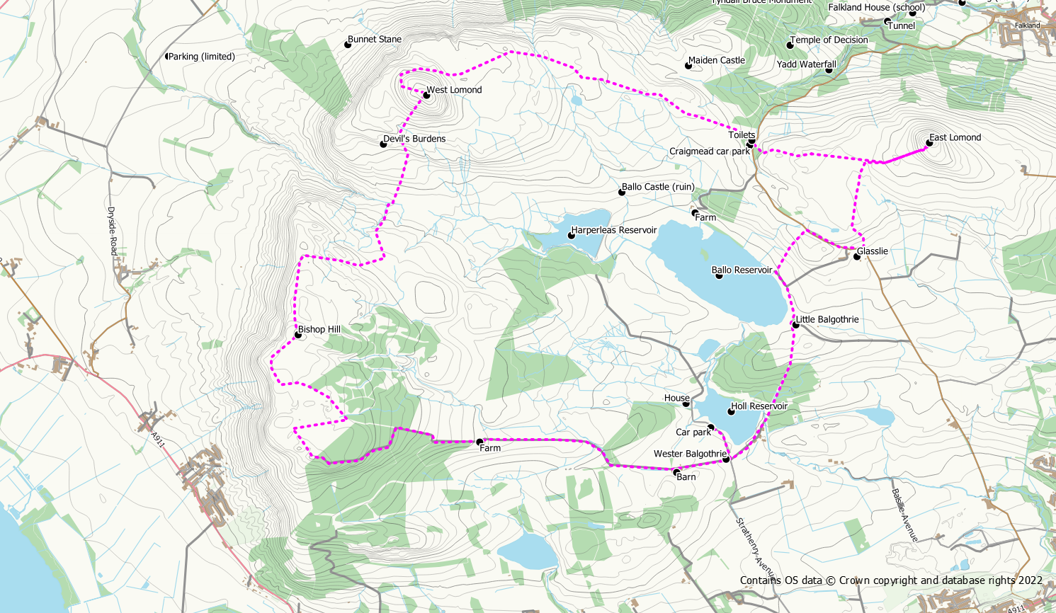
The route described below starts from the Holl Reservoir car park and goes in an anti-clockwise direction. Walking anti-clockwise has the advantage of going down rather than up the steep south side of West Lomond, although what was just feint path amongst the heather is becoming well trodden nowadays.
- Distance: 20.3 km / 12.6 miles
- Ascent: 750 m / 2460 feet
- Terrain: Tracks, surfaced paths and trodden hill paths
- Start / finish: Holl Reservoir Car Park at grid ref NO 224 035, accessed from the A911
Route Map
Route Description
From the Holl Reservoir car park, head south back down the road to the crossroads and turn left towards the dam. Follow the road along the dam and past the Scottish Water premises. Then follow the trodden path upwards through the woods. Once out of the wood the next landmark is Balgothrie Farm. Walk round the left side of the farm and pick up the path going round Ballo Reservoir keeping the reservoir to your left. Just before the fishing hut, the path turns right and heads upwards across grassy fields to join the public road. Turn right and walk down the road passing Wester Glasslie Farm on your right. Look for a stile on your left on the corner. Cross the stile and cross the field aiming for the marker post on the hillock. The path is more obvious after this. You will need to leave the path when you see the limekiln to your left and aim for the gate/stile to the left of the lime kiln at the foot of East Lomond.
After exploring the lime kiln, join the main track going up East Lomond, keeping to the left at the junction. This particularly part of the path is quite steep and is badly eroded in places. The worst of the erosion can be avoided by taking a line to your right. After enjoying the views from the summit of East Lomond, return in the same direction but when you reach the limekiln stay on the main track continuing downhill to reach the Craigmead car park.
From Craigmead continue to follow the wide track westwards to West Lomond. At the foot of West Lomond you can either ascend directly up the hill or you can stay on the track as it winds it way up the back of the hill at a more gentle gradient.
Descend from West Lomond to the south west. You should be able to pick up a feint path in places. Cross over a fence where there is a new substantial stile and follow the path down to the Devil’s Burdens (a collection of rocks on the side of the hill which are said to have been thrown by the Devil at a local witch). This area is very dry and you could almost imagine yourself in the desert. Pick your way through the rocks and try to pick up a path through the heather taking you down the hill to the Glenvale path. Look back for the best views of the rocks. Once on the main path, look for a gate on the opposite side at NO 194 056.
Go through the gate and follow the path up hill alongside a fence until it turns to your right. The path continues upwards through a hillocky area populated by old larch trees. After the trees the path joins the main ridge of Bishop Hill. Turn left now and continue on the path upwards until you see the summit of Bishop Hill ahead of you. A short detour away from the fence you are following will take you up on to the summit of the hill. Before going on to the summit though, if you stay alongside the fence you will reach a spot where you can view Carlin Maggie (the local witch mentioned earlier that the devil later turned to stone) on the cliffs to your right.
From the summit it is tempting to take a direct line towards Munduff Hill but as of Autumn 2022 there is now an electric fence which will need to be crossed. It’s probably best therefore to descend south west to reach a metal pedestrian gate at a junction of fences/walls. Follow the obvious path through the gate and across the moorland in a south and then easterly direction to reach another junction with gates. Go right at this point leaving the obvious track for a trodden path heading south towards Munduff Hill and the golf ball. As the area of Munduff Hill is reached, there are some additional lumps and bumps that can be included before reaching the actual summit which no longer has a summit cairn.
From the summit of Munduff Hill you should see a new gate leading into the forest. Go through this gate to reach the “golf ball” (a rain radar station for the Met Office). It’s all downhill now and a good forest track takes you from the golf ball to the edge of the forest where you turn right onto a farm track. Follow this track downhill passed West Feal Farm until it brings you to the crossroads at Wester Balgothrie Farm where you started.
