This is a relatively easy walk around the farmland of north Fife. Perfect for an afternoon stroll. Both Craigsanquhar Hill and Craigsanquhar South Top can be included as optional extras for vey little extra effort.
- Distance: 8 miles / 12.8 km (without Craigsanquhar Hill)
- Ascent: 870 feet / 260 m (without Craigsanquhar Hill)
- Terrain: Paths and tracks with some road walking. Some sections can be a bit muddy.
- Start/finish: Dairsie
- Facilities: On-street parking, regular bus services to Dairsie.
Route Map
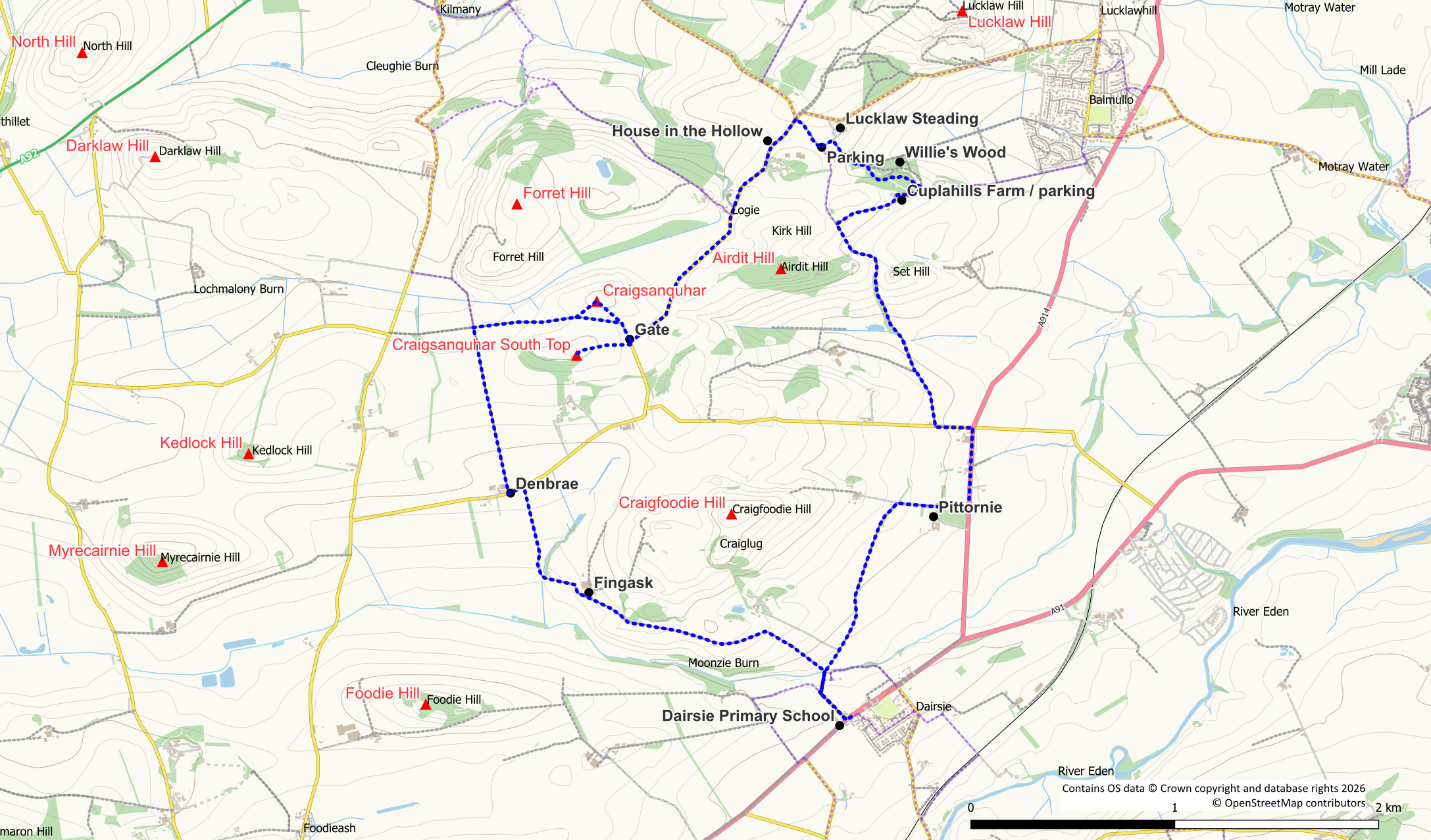
This walk can be started from the primary school in the village of Dairsie where a green Scotways sign indicates a right of way to Foodie. Alternative starting points are also possible around the route. Follow the Foodie track to the white cottages and turn right passing in front of the cottages. After the cottages, turn left to Fingask following a purple core path arrow marker. Keep to this surfaced track for the next 2.5km, initially uphill passing to the south of the obvious hillock of Craiglug. On reaching the path summit the views ahead open out over the north Fife hills: Foodie Hill, Myrecairnie Hill, Kedlock Hill, and further in the distance, the distinctive Mount Hill. Descend past Fingask before heading slightly uphill again to meet a public road at Denbrae. Turn left here (there is a purple core path arrow) and almost imemdiately turn right on to a track beside an abandoned building.
The next 1km is easy walking on the farm track although it can be a bit muddy underfoot at times. Ahead of you rises the gorse clad slope of Forret Hill. On reaching a junction before the hill, turn right on to an unsurfaced path. This path heads through a bit of gorse which soon gives way to more open ground as the path becomes a wider track. The 159m summit of Craigsanquhar Hill (classified as a Tump) lies to your left in a grassy field and can easily be included. There are a couple of gates to facilitate access into the field. Note, that livestock may be grazing in this field. Return to the track.
The track turns sharp right, meeting with a public road at a gate. To your right is the 158m summit of Craigsanquhar South (classified as a Tump Beag). Again this wee hill can be included if desired. Simply follow the fenceline up grassy slopes to reach the summit area. To access the scrubland of the actual summit it is necessary to cross a barbwire fence. Return to the road at the gate.
From the gate turn left onto the road. There is now 1.8km of tarmac walking along this quiet road. Approximately half way along you reach the small settlement of Logie. Beyond Logie you pass Logie House and the aptly named House in the Hollow. When the “main road” turns sharp left at an obvious crossroad, turn right heading into Cuplahills Community Woodland. 250m of surfaced track brings you to a junction and small parking area (rather muddy). Go left here towards the farm at Lucklaw. Before reaching the farm, turn right on to an unsurfaced path signed as a woodland walk. This next path section is a lovely stroll through Willie’s Wood, named after local man Willie Melville who planted both this and nearby Lucklaw Wood. At the first path junction in the woods keep right. After this you have a choice of routes. It doesn’t really matter which route you choose a both will bring you to some picnic tables at a viewpoint above Cuplahills Farm. As well as picnic tables there are also pet memorial plaques in the area. Exit the woods at Cuplahills.
From the picnic tables turn right downhill towards the farm and a small parking area (much drier than the previous one). Follow the core path between the farm buildings. Bear in mind that this is a working farm so be alert to moving vehicles/machinery and keep dogs at heel. Stay on the surfaced track, turning left at the next junction downhill towards Airdit. On reaching an arrow marker post at the bottom of the hill leave the track, turning left. Initially you will be on an unsurfaced track but beyond the hillock of Set Hill the track becomes a narrow path. This path is once again a delightful woodland walk though it can be muddy underfoot. Follow it downhill to cross a small burn and then gently back up the other side. On meeting a surfaced track, turn left out to the public road where you want to turn left once again to reach the main A914 road.
The next 500m though still on a core path, do unfortunately follow the main road. There is a bit of a pavement / path on the opposite side of the road which can be used. After 500m an obvious side road is reached on the right. Although this may look as though it is private access it is core path. Turn right here passing Pittornie. Make an obvious left turn at a junction with a sign, on to a field track. From here it is approximately 1.3km across open fields back to Vantage Cottage at the start of the walk. When crossing the field please remember to stay on the track and don’t let dogs roam across the fields when there are crops growing. At the cottages a left turn will take you back to the village of Dairsie.
