Gauldry and Wormit Circular
A mixed circular walk starting from Gauldry, taking in part of the Fife Coastal Path, the Wormit Hill viewpoint and local core paths. There is an option to extend the walk through Ghoul’s Den though this section is a bit rough underfoot
- Distance: 13 km / 8 miles (16 km / 10 miles with Ghoul’s Den)
- Ascent: 320 m / 1050 feet (415 m / 1360 feet with Ghoul’s Den
- Terrain: Mixed. Unsurfaced paths (can be muddy), tracks, field edge paths
- Start / Finish: Gauldry
Route Map
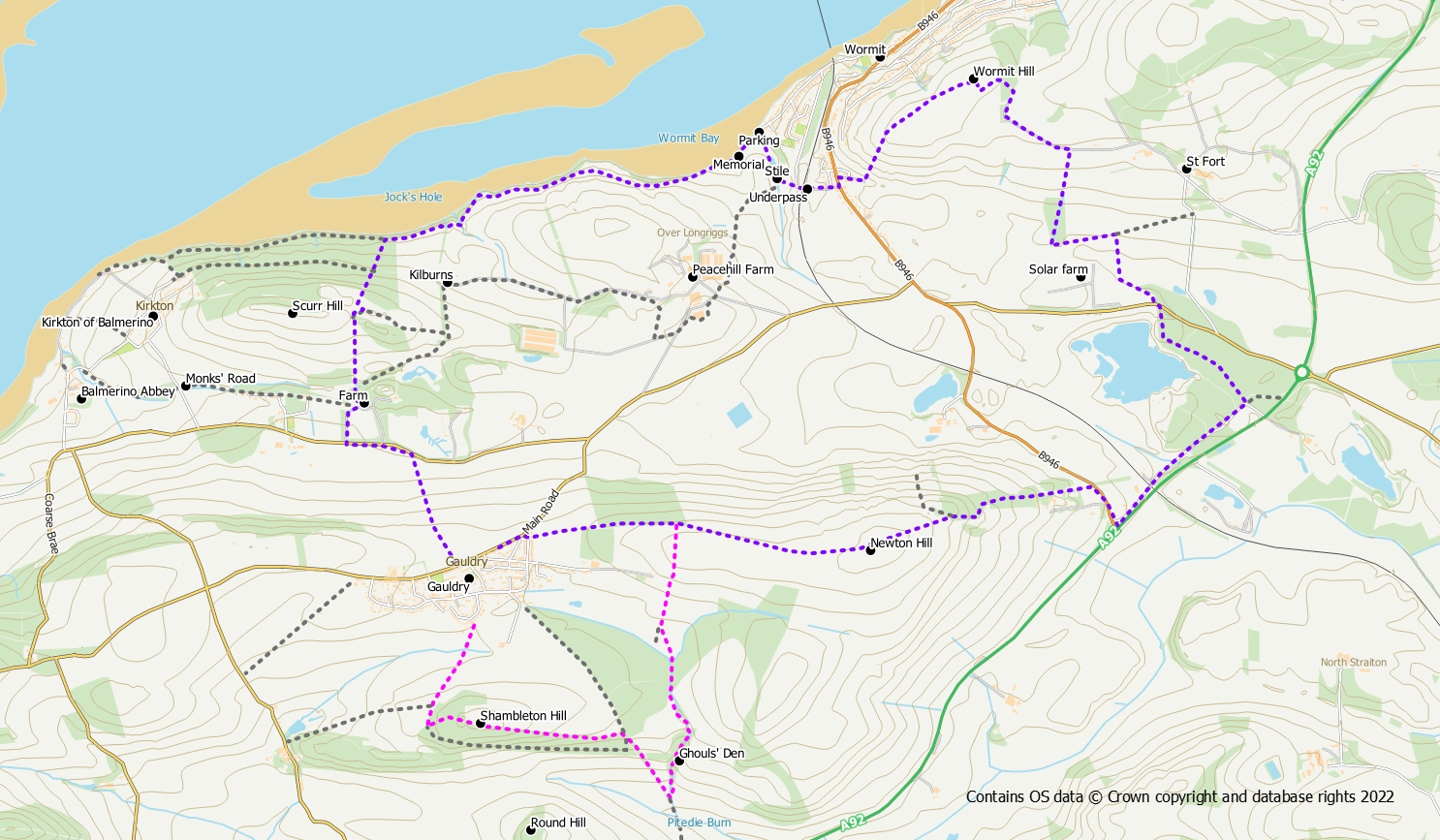
Starting from Gauldry main street a core path heads north across the fields, starting opposite number 8. After about 600m a quiet road is reached. Turn left along this road for almost 400m to reach the entrance to Naughton Farm. This is the second entrance on the right, the first being Naughton House. Follow the track around the farm in a northerly direction, keeping the main farm buildings on your right. Keep straight on when a sign points right to Kilburns. 400m beyond the farm a gate is reached.
Once through the gate there is a bit of a “tangle” of trodden paths around the gorse bushes to choose from. Right, left and then right again, seems to work but it doesn’t really matter which paths you use. You need to end up heading north downhill through trees on a trodden path with the Tay in front of you. This trodden path is quite steep and may be slippery in places. The path will cross a grassy track (turning left here will take you to Kirkton of Balmerino and this can be added on to the walk if desired) and then meet up with the main coastal path.
Turn right on to the coastal path and follow it to the car park at Wormit, passing a couple of wooden seals and the Tay Bridge disaster memorial. From the car park, go right on the signposted path up the hill. After passing a pond, go left aiming for the tunnel under the railway. Once through the short tunnel a track takes you out to the road. Turn left and then right onto an obvious signed track. After just 150m there is a trodden path to the left heading up the grassy hillside. Head up this path following it round to the right, firstly north-east and then more easterly towards the small 99m summit of Wormit Hill. The summit is a slight detour off the path to the left. It might not be very high, but Wormit Hill is a fantastic viewpoint over the Tay to Dundee and beyond.
Return to the path and continue to follow it in a north-east direction, now around a field edge. Please take care to stick to the path as this is an arable field. Please also ensure that dogs are kept to the path and not allowed to roam across crops. The path follows the edge of the field and then goes through a short section of woodland to meet with a track.
Turn right on to the track following it slightly downhill for around 500m to where an surfaced track heads right, downhill between fields. Follow this track down the hill and through a wooded area emerging at the back of a solar farm. Go left around the solar farm, turning right along a field edge path at the side of the solar farm. Follow the edge of the solar farm to the corner. Keep close to the solar farm fence at this point and then strike off left on a trodden path with the wall to your left. The path follows the wall around the edge of the field out to the road where you need to step over the fence in order to reach the road.
Cross the road and pick up a trodden path on the opposite side, down a bank, into the woods. Keep to this path (which could be muddy after heavy rain) as it bears left and uses the higher ground through the woods (this is not the same route as shown on the core path maps). The path meets a more obvious surfaced path at a crossroads where you want to turn right. Follow this surfaced path in a south westerly direction. Exit the woods, still on the same path (which has become more of a track), pass under the railway line and join a road at the bus depot. After 200m this road meets up with another road (the road into Wormit) where you want to turn right. Walk up this road for 200m, past the holiday cottages entrance, to reach a signposted path on the left.
Take this path to Gauldry over the shoulder of Newton Hill. Initially the path / vehicle track is uphill on rough scrubland. As height is gained it becomes more grassy as it follow the fence line. Be careful to follow the path up hill alongside the fence, when the vehicle track starts to go downhill. The grass path heads up the hillside towards a communication mast. The actual 144m summit of Newton Hill is on the opposite side of the barb wire from the path but the views are just as good from the path side. The grass path continues down the western side of the hill to reach Brownie Wood on the outskirts of Gauldry.
From here it is a straightforward walk of less than 1km back to Gauldry on the path through the woods. This may be your preferred option to finish up the walk.
If you don’t mind a bit of rough underfoot walking (which could be overgrown in summer) it is possible to finish up with an exploration of Ghoul’s Den to the south of Gauldry.
For this option, go right through a pedestrian gate at the corner of the woods. Now go southwards on a field edge path slightly up hill and then downhill to join a track. Continue downhill on the track almost to the sewage works. However, before reaching the sewage works, cut into the grassy field on your left. Cross this field diagonally in a south-easterly direction to enter the woods in the far corner. Cross over a ditch. There is a rough path through these woods that follows the course of the small burn in a roughly south direction into Ghoul’s Den. Keep to this path parallel to the burn to the reach the southern tip of the woodlands. Cross the burn to exit the woods into a field. Go right alongside the edge of the woods to exit the field onto a good track. Turn left onto this track for a straightforward 1.2km walk back to Gauldry.
However, for another short and straightforward extension it is also possible to include Shambleton Woods and the 134m Shambleton Hill. 400m after exiting the field on to the track an obvious track junction is reached. Keeping straight on is the direct way back to Gauldry; a distance of around 900m. However turning left provides a pathed 1km woodland walk through Shambleton Woods. On reaching the western edge of the woods, turn right for an 600m path walk back to Gauldry
