Ladybank Woodlands Circular
Ladybank is almost surrounded by Forestry and Land Scotland managed woodlands. These woodlands are generally planted with mature Scots Pine and hence provide very pleasant walking in a relatively light and airy environment. Although all the woodlands are themselves each quite small in area, by linking them together a longer walk can be formed. There are numerous paths (both formal and informal) in the woods and the route suggested here is just one possible option. Shorter walks can of course also be undertaken by exploring the individual woodlands by themselves.
- Distance: 12.4 km / 7.7 miles
- Ascent: 90m / 300 feet
- Terrain: Mix of uneven, unsurfaced informal woodland paths and constructed/maintained paths. A few sections of tarmac.
- Start / finish: Ladybank. There is parking and public transport in the village along with refreshments. Alternatively, there a number of parking areas on the route that can be used.
Route Map
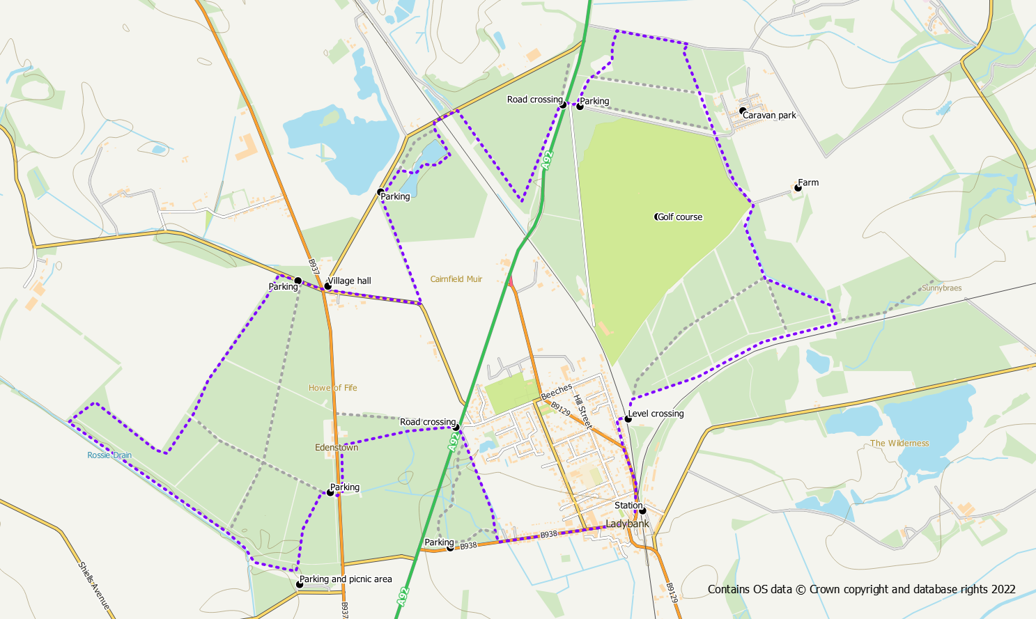
Starting from Ladybank head out of the village westwards on Commercial Road. After the last houses, on the right hand side, is an access point into Monkstown Woods over a small wooden bridge. At the first path junction you can either keep straight on along the core path or turn left to reach a car park where another path heads northwards through the woods. Either way you need to reach the top north corner of the woods. From here, follow the path out to the main road, take extreme care and cross over.
On the opposite side either use the core path signed for Edenstown or use an informal path in the woods. If you chose the former option, on reaching the end of the path at Edenstown turn left down the road past the older houses and re-enter the woods opposite the newer houses. If you chose the second option just follow the path round to the left so that you are walking southwards parallel to the road. The path exits the woods opposite a parking area. Cross over the road and walk through the car park into Heatherhall Wood.
From here there are numerous paths through the woods and it’s not important exactly which ones you use provided you stick with the right general direction. Take one of the paths on the left so that you are walking roughly south. After approximately 400m you will reach another car park and picnic area. Turn right on one of the paths heading north-west for just over 1km. On reaching the edge of the woods follow the path round to the right, and then right again now heading south east. The path follows the edge of the woods and after about 400m turns left so that you are heading north east. The next 1km is along this path following the edge of the woods to reach a minor road to the north of the woods.
Turn right on to this road for 200m to reach Charlottetown. With Giffordtown Hall to your left follow a quiet tarmac road for 450m to where it turns sharp right. A signpost indicates a path on the left to Collessie. The path continues north west for 500m to reach another road and a parking area. At this point turn right into the Cairnfield Muir woods off the road. The path heads north-east through the woods parallel to the road and can be followed to the point where it exits the woods at their northern corner. However, a more interesting option is to turn right after 170m on an obvious trodden path into the woods. This path will bring you to a couple of ponds. A good option is to cross between the ponds (might be very wet underfoot after heavy rain) to pick up a path on along their eastern shore. This pleasant path makes its way around the ponds, turning left parallel to the railway to reach the northern corner of the woods.
From this northern corner of the woods head out to the road to use the bridge under the railway and then turn immediately right into more woodland. Follow a path along the edge of the woods in a south-east direction(parallel to the railway) for 500m then turn left on a path now parallel to the main road. Keep to this path at the edge of the woods rather than using any of the paths that go deeper into the woods. After a further 500m, a path turns off to the right leading out to the main road.
Take extreme care and cross the fast and busy road to reach a parking area on the opposite side at the entrance to the golf course. Turn left into North Annsmuir Woods at this point on an obvious path. Again there are a number of paths in the woods and any of them can be used to reach the eastern side of the woods where a caravan park is located. When you reach the eastern side, keep the caravan park to your left and walk south-(ish) to reach the corner of the golf course.
Use the obvious track alongside the golf course (watch out for golfers) in a southerly direction to reach South Annsmuir Woods. Go through a barrier gate onto a wide forest path and follow it through the woods. Again there are numerous paths in the woods and the exact ones you use is not important provided you end up at the south-western corner of the woods. Using the main track, follow it for about 350m to reach an obvious junction. Any option can be used here, but for a change of scene, go left and keep to the path until you reach the railway. From here, turn right on a grassy path outside the forest. After about 1km along this path, the south-western corner of the woods is reached.
At this point, there is a level crossing over the railway back into Ladybank. Turn left onto Golf Street back towards the centre of the village.
