Hills: Lumbennie Hill (284m), Pitlour Hill (275m), Colzie Hill (215m), Yellow Hill (200m), Gowk Hill (190m)
These hills, all of which have Innerdouny in the eastern Ochils as their parent Marilyn, make up the high ground in the north of Fife between Newburgh and Auchtermuchty.
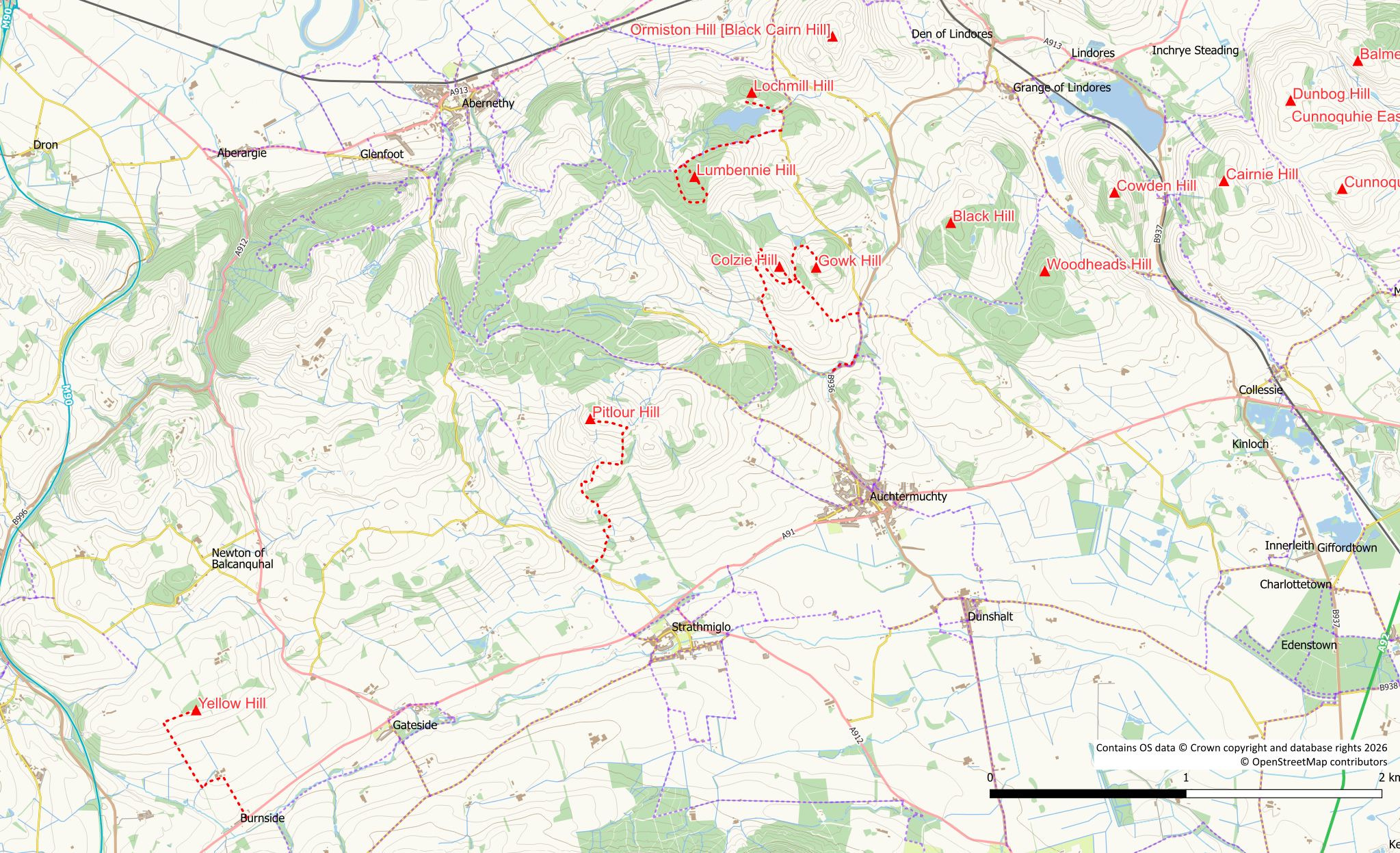
Map
Lumbennie Hill (284m)
This is the highest point in Pitmedden Forest. Again, it is a hill clad with forestry and the route to the summit is rather rough.
The shortest approach is along the track / cycle route from the road at NO 227 160 where there is room to park a few cars. Use the forest track to reach the northern side of the hill. From here there is a rough path through the firebreak under power lines to the unremarkable summit marked with an OS trig point. It is possible to descend to the south east and use the forest tracks to circle clockwise around the hill back to the northern side.
The hill can also be approached on forest tracks through Pitmedden Forest. There are good tracks / paths through the forest from Auchtermuchty (The Clink), Abernethy Glen and Abernethy.
Pitlour Hill (275m)
The easiest approach is from the entrance to Pitlour Estate at NO 205 109. However as there is no parking in the area you might be as well starting at Strathmiglo and using the path network to reach the entrance gate.
Once in the estate follow the track, keeping left at the first junction heading towards the ruins of Wester Pitlour. Keep on the main land rover track following it up hill and left at an obvious junction. The track continues to climb, bearing to the right at a corner with three “standing stones”. Keep to the track circling a hillock until it enters a field. Cross the field on what is now a very feint track aiming towards a deer gate on the far side. Once through the gate it is now an easy walk on track to both the summit and trig point (the trig point is not at the actual summit).
The hill can also be approached from the Pitmedden side using field edges to reach a gate at NO 21353 12632. From here there are quad bike tracks to the summit. A few barb wire fences need to be negotiated on the lower slopes.
Pitlour is a working estate so ensure your actions are in accordance with SOAC. Access during the shooting season is probably best avoided as this is pheasant rearing country.
Lochmill Hill (212m)
The 212m Sub-tump (hills with between 20m and 30m prominence) of Lochmill Hill lies to the north of the lovely Lochmill Loch near Newburgh. Start from the fishery parking area at the dam, heading west along a track. Stay on the track, don’t follow the lochside path (though this makes a very pleasant diversion). Leave the track around the north side of Lochmill Loch via an old wooden gate at approximate grid reference NO 22321 16449. The gate is probably best squeezed through rather than opened but at least it provides a means to cross the deer fence. There are a few gorse bushes the other side of the gate but once clear of these the walking is easy enough through mature conifers. An old wall is easily stepped over and a 2nd wall with a barbwire fence is also easily negotiated. There is however, an open gateway at approximately NO 22337 16537 which can be used if preferred. A final sting in the tail, the summit of the hill is crowned with a bed of nettles in the summer months. Return back to the gate in the deer fence and the track.
Yellow Hill (200m)
Listed as being 200m in the Database of British and Irish Hills, the OS maps shows this one as being 199m. Ascent is easy enough but hampered by 3-strand electrified fences.
Start either from Burnside off the A91 or the junction of the road to Carmore at NO 15359 09536 (if there’s insufficient room to park at the junction there is space up the road at the cemetry). Head along the farm track (signposted at the Carmore side) between Carmore and Burnside (via Bannaty) to reach a gate just south of its high point. Although you could access the hill via the rough ground and gorse bushes on its southern slope this would be hard walking and it is much easier to negotiate the electric fence and use the field edge. From the northern side of the gate squeeze under the fence and over a small wall into the grass field (livestock may be present). Follow the field edge to the felled tree area where you will once more have to negotiate an electric fence (walk round the trees a bit to find a good spot). Once into the felled area there is the line of a trodden path to make things easier. The summit itself is hard to distinguish and has no marker. The trig pillar lies on the opposite side of the track and is easier to reach than the summit as it is not protected by electric fences.
You could probably avoid one of the electric fences if you approached from Balcanquhal.
Gowk Hill (190m) and Colzie Hill (215m)
These two hills are classified as Sub-tumps meaning that they have between 20 and 30m of prominence (all round drop). They lie on farmland (grazing) close to Pitmedden Forest. Livestock may be encountered in the fields around Gowk Hill. Please ensure you leave all gates as you find them.
A suitable start point is the Auchtermuchty Common parking area at NO 23703 13554 on the B936. Initially walk up the road (no pavement) to the access road to Easter Colzie. Turn left into this road, then after 300m turn right on to a landrover track up the hillside. On reaching the white house at the top of the road keep left of both it and the barn/stable on a grassy track. Probably the easiest way to approach Gowk Hill is from the north rather than a more direct approach which entails gorse, nettles and an electrified fence. So keep on the track passing a brick building and circling around through pasture land with openable gates until you are north of the hill. The gorse can easily be walked around on rough tracks otherwise the approach is on grassy (pasture) hillside.
It’s probably best to return back to the white house rather than to try a direct route across to Colzie Hill as there is much gorse on the east of Colzie Hill. A gate to the west of the house provides easy access to the scrub land of Colzie Hill. Turn right up the slope to reach the summit.
To continue as a circular walk, leave Colzie Hill either in a northerly or southerly direction. A direct descent to the west would take you into thick gorse and rough ground. Pick your way down the hill and around to the west side crossing under the powerlines. Between the powerline and a fence is a rough field track which can be picked up to ease progress. Follow this track north alongside the fence. A gate to your left can be climbed over to access the adjoining field or continue onwards to the edge of Pitmedden Forest. From the corner of the forest a couple of gates can be used (one needs climbed) to turn back on yourself (south) into a grass field. Be careful at the second gate as the adjoining fence is electrified. Cross the grassy field on an ATV track passing under the powerlines. Go through another gate into the next field which may contain horses. A reasonable track crosses this field to reach the farm at Pitmedden. A pedestrian gate leads out to the farm road which can then be followed downhill to the public road. Turn left on reaching the road and then left again after 500m on to the “main” road. After Glassarts Cottage there is a path on the left which can be used to avoid walking back up to the road to reach the start point.
You may also be interested in:

