Hills: Newton Hill (144m), Shambleton Hill (134m), St Fort Hill (123m), Craig Law (112m), Hare Law (111m), Chester Hill (107m), Round Hill (106m), Scurr Hill (104m), Wormit Hill (99m), Knock Hill (91m).
A selection of smaller hills located in the far north east of Fife.
Map
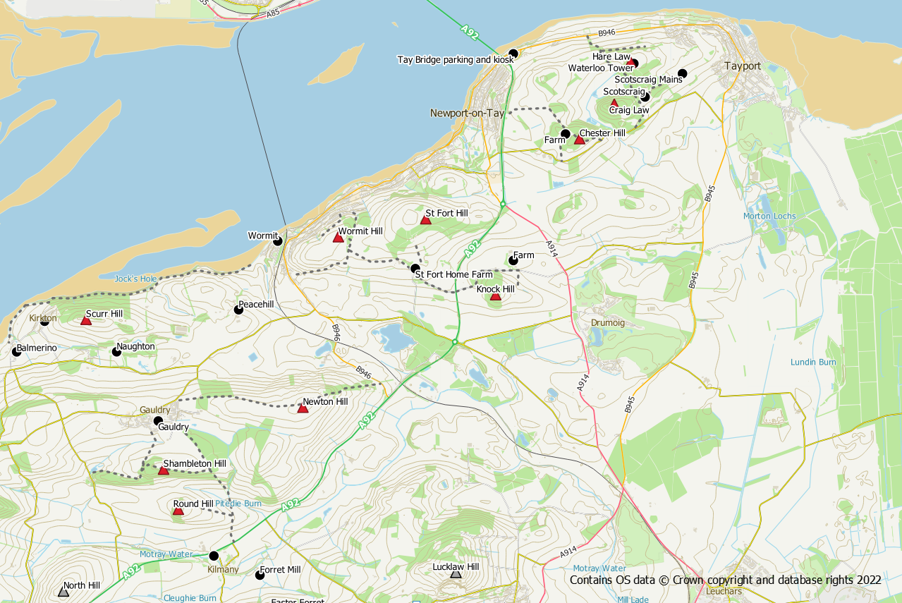
Newton Hill (144m)
Newton Hill lies to the east of Gauldry and can be accessed via a pleasant 1 mile walk along a core path from the village. However, the path crosses the grassy hill on the northern side of a barb wire fence but the summit lies on the southern side of the fence. The easiest place to cross the fence is at the gates (need to be climbed) at NO 39364 23895.
Shambleton Hill (134m), Round Hill (106m)
The wooded Shambleton Hill lies south of Gauldry. It is easily reached via a 0.5 mile woodland walk on paths. The summit itself is indiscernible but probably lies on the southern side of the path.
Round Hill is also south of Gauldry and can be reached by means of the core path between Gauldry and Kilmany. A 700m section of track runs west from the core path past a wind turbine to a gate giving access to the summit area. The summit itself is rough brash and not particularly easy underfoot.
St Fort Hill (123m)
This woodland hill lies on the St Fort estate to the south of Newport-on-Tay. There are paths and tracks in the woodlands which can be accessed from within the estate grounds at Northwood Cottage or from the main road near the Forgan roundabout. It’s difficult to know exactly where the summit it is but the paths take you close to it.
Craig Law (112m), Hare Law (111m), Chester Hill (107m)
These three hills form a compact group at the southern end of the Tay Road Bridge. All three summits lie in woodland with rough underfoot conditions.
Chester Hill – this is the easiest of the three and is a short walk from the back of the ruined cottages at NO 435 276. Access to the cottages is via a signposted path which starts from the minor road NO 438 275.
Craig Law – This one is a bit more challenging as the conditions underfoot are somewhat rough where grass and moss has grown over fallen branches. Leave the track in the Scotscraig Estate at NO 442 281 initially up a steep bank. The summit is approximately 250m into the woods.
Hare Law – Perhaps the most interesting of the summits due to the presence of the remains of Waterloo Tower. However, it is not particularly easy to reach. A gate at NO 443 282 in Scotscraig Estate provides access to a very rough, feint track which makes its way around the back of the buildings. It then follows the route shown on the OS Explorer map north to the vicinity of the summit. If approaching the summit from the north a barb wire fence needs to be negotiated.
Scurr Hill (104m)
An easy diversion from the Fife Coastal Path near to Balmerino. Leave the FCP at NO 37346 25440 on a rough path leading into the woodland and uphill. The path doesn’t go all the way to the crest but access is easy enough through the trees. Once on the crest there is a path all the way to the summit. Can also be reached from Kirkton of Balmerino via a field edge followed by woodland path starting at NO 36201 24987.
Wormit Hill (99m)
This wee hill is a fine viewpoint over the Firth of Tay. It is easily accessed by means of grass paths from the back of Wormit or via the core path starting from Kilmany Road. Other access is also possible from the St Fort Estate by means of core paths.
Knock Hill (91m)
Not to be confused with its better known namesake in south west Fife, this hill is located in the St Fort area close to Newport-on-Tay. Access is easiest by walking up the private farm road from the A91 to reach the woods. Keep left of the house and head up the wooded hill on a bit of a track. Leave the track heading east up the hill to reach the summit which is easy to find.
