Scotscraig and Morton Lochs
Two suggested walks in the Scotscraig Estate above Tayport.
Route Map
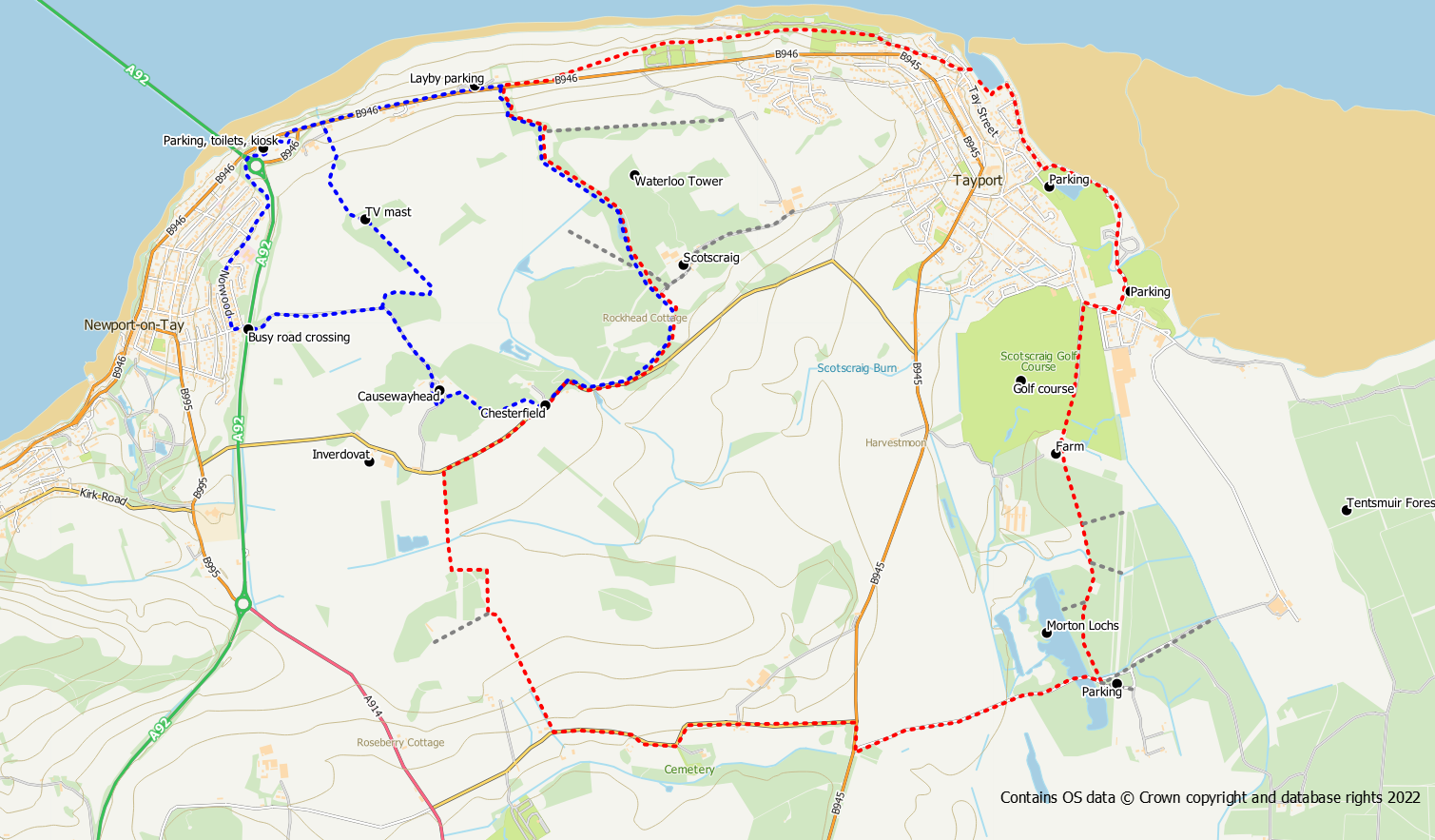
Scotscraig and Morton Lochs Circuit
A pleasant circular walk exploring the Scotscraig Estate, farmlands, and the Morton Lochs nature reserve.
- Distance: 12.5km / 7.7 miles
- Ascent: 150 m / 500 feet
- Terrain: Mix of paths/tracks, quiet road and field paths (potentially muddy)
- Start/finish: Tayport
From Tayport Harbour use the coastal path westwards towards the Tay Bridge. As Tayport is left behind, the route enters woodland. At a split in the path, keep left on the signed route, passing behind the cemetery to reach the main road.
Cross over the road and enter the Scotscraig Estate by means of a track through the gate. Head up the hill through the woods, keeping right at a junction. At the top of the hill keep straight on downhill with an open field to the left. Stay on the main track to reach the public road. Whilst in the estate you may be tempted to visit the Waterloo Monument. However, it is somewhat awkward to reach. A rough track starts from a gate at NO 44353 28210. The track goes round the back of Scotscraig and makes its way north towards the tower. The final section is rough off path in the woods.
Turn right on to the quiet road and follow it for about 1km until a stile with a signpost is reached on the left hand side (if you reach Inverdovat you’ve overshot the stile). Before reaching the stile you will pass the intriguingly named Washer Willy’s. Use the stile to cross the wall onto a field path. This core path crosses fields so take care to keep to the path line and don’t let dogs roam across growing crops. The path enters a small woodland area before again following more field edges.
On reaching the next public road, go left for about 1.3km to meet the main road into Tayport. Cross over the road and slightly to the right is the access road into Morton Lochs reserve. A further 1km of road walking is required along this road to reach the area of the lochs. Follow the path around the east side of the lochs and then through the woods, fields and golf course to the edge of Tayport.
Turn right, then left past the parking area to enter the caravan site. The coastal path route now passes through the caravan site and playing fields before meeting the residential streets of Tayport for a short walk back to the harbour.
Scotscraig Exploration
A shorter alternative option focussing on the Scotscraig Estate is also possible.
Distance: 6 km / 3.7 miles
Ascent: 120 m / 400 feeet
Terrain: Mix of paths/tracks, quiet road
Start/finish: Tay Bridge
Start from the layby on the B946 opposite the Scotscraig track or walk along from the Tay Bridge car park. Follow the main tracks through the estate as detailed above, exiting out to the public road. Go right, along the road for about 600m to reach the cottages at Chesterhill. After the houses, there is access to a signposted field edge path on the right. The path heads into the woods to the farm of Causewayhead. Join the core path on the west side of the farm heading northward. The track turns sharp left at an obvious junction. From here there are two options back to the Tay Bridge.
- Turn left on the core path and follow it in a westerly direction to reach the busy A92. Take EXTREME CARE crossing the dual carriageway to reach the road opposite. Head down the road, turning right into Norwood and follow the road to where it turns left and becomes Craighead Crescent. Keep straight on at this point on an obvious path at the back of Newport, passing under the road at the bridge to emerge at the carpark. From here the coastal path can be used back to the layby if needed.
- Alternatively, if you don’t mind a bit of gate climbing and fence negotiating there are superb view from Northfield above the bridge. Keep straight on, leaving the core path, when the track turns sharp left, on a track leading up to the TV mast. On reaching the mast compound it will be necessary to climb the gate and then squeeze through the fence on the left into the woods and out to the open hillside. Once out of the woods there is a panoramic view over the Tay to Dundee and beyond. From the trig pillar, head north-ish down the hillside to an old quarry area. From here there is a farm track back down to the road although another gate will need to be climbed.
