Hills: Beld Hill 412m, Craig Rossie 410m, Ben Effrey 363m, Castle Craig 139m.
These hills form a distinctive compact group to the southeast of Auchterarder. Viewed from the town the outcrop of Craig Rossie is particularly prominent in the view. The highest point, Beld Hill, however lies to the back out of sight. As well as the two main hills there are also two hillforts which are both worth a detour. Ben Effrey is the higher one and affords superb views out across Stathallan and Strathearn.
- Distance: 9.7 km / 6 miles
- Ascent: 460 m / 1500 feet
- Terrain: Farm track, ATV tracks, paths and some off path on tussocky moorland
- Start / Finish: Pairney Farm near Auchterarder NN 978 132.
- Facilities: Parking in layby at NN 972 131. Although some people do park at the Pairney track entrance bear in mind that this track is used by large farm vehicles. The layby to the west of the farm is small but it’s out of the way. Other facilities available in Auchterarder.
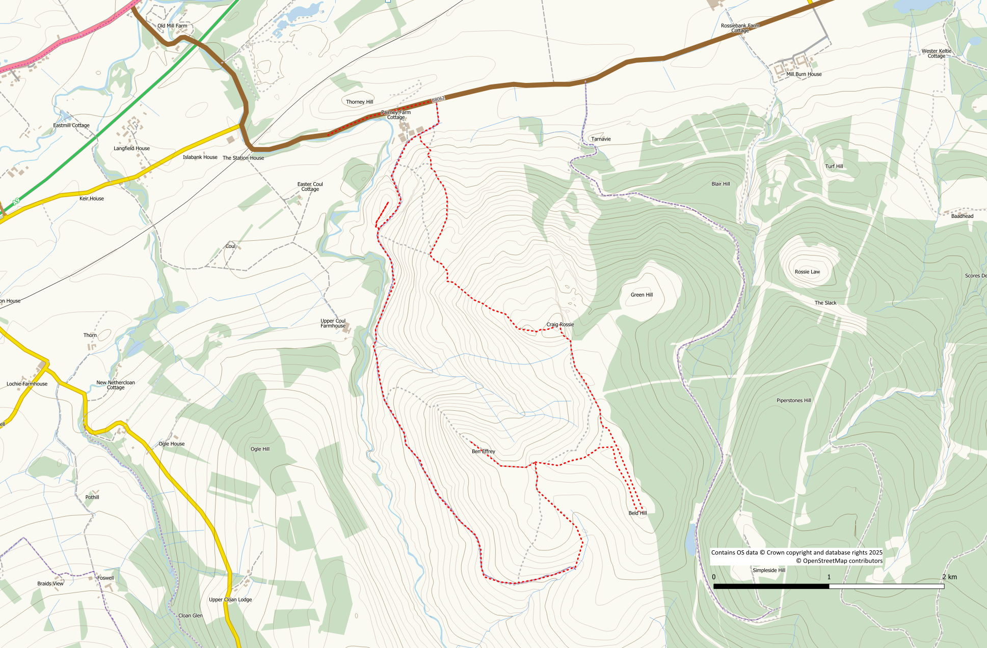
Commence the walk at a track entrance approximately 200m east of the farm at Pairney. This track which circles the western slopes of Ben Effrey is a Perth and Kinross core path. However, it is a farm track and there may be livestock grazing alongside, or even on it. The track bears right to go around the outside of the farm buildings. Then, it starts its gradual ascent to the higher ground passing through an old quarry.
After leaving the farm it is worth making a short detour to the remains of the Castle Craig fort to the right. Whilst the eastern slopes are steep and cliff like, there is easy access up the southern slope. A rough trodden path heads up the hillside starting from a gateway at NN 975 126. Explore the hilltop then return downhill the same way back to the farm track.
The track now provides easy walking around the western side of Ben Effrey gradually gaining height. After a couple of kilometres the track bears round to the left (east) heading up the slopes of Beld Hill. There are a couple of options to ascend this hill. Option 1 is to leave the track on an obvious ATV track on your left when the farm track heads away from the fence on your right. Option 2 (shown in red on the route map) is to walk to the end of the track. Then, follow its continuation, left up the grassy hill beside the Beldhill Burn. The route now becomes a trodden path as it gains height and re-joins with the ATV track. The hillfort of Ben Effrey is an obvious feature ahead of you. Turn right on to the ATV track (just stay on the track if you took option 1) up the hillside. Keep left at a Y junction to reach an obvious path junction.
The path to Ben Effrey is on your left. It is worth making the detour to this hillfort site with its spectacular views. A small amount of height is lost before the path starts its ascent. If you don’t like the idea of losing height a more direct route over tussocky grass would be possible. The path ascends to the summit of Ben Effrey at 363m. However, this is not the fort site or the best viewpoint. Continue over the summit losing about 10m of height before reascending to the small cairn.
Return by the outward route over the summit back to the start of the Ben Effrey path. Keep straight on crossing over the first ATV track. At the second ATV track keep straight on as well, now walking on the track again. Stay on this obvious track heading eastwards. Keep to the main track ignoring a path going off left. As the track starts to approach a fence bear right on to a feint trodden path. If you miss this path don’t worry as you can can simply turn right on reaching the fence line. The path does however provide easier underfoot conditions.
The summit of Beld Hill is actually the point shown as 410m on the current OS Explorer map. This southern top is 412m and is the recognised summit. The northern top is also recorded as being 412m. The Harvey Ochils map shows the summit more accurately.
The trodden path passes around / over the northern top. Once over this top there are a number of feint paths and tracks heading south to the summit. Any of these can be used as they all provide easier walking than the tussocks. Beld Hill summit is flat and featureless with not so much as a cairn to mark it.
Return northwards on the paths/tracks over the north top. Drop down the north side of this top with the mass of Craig Rossie ahead of you. Re-join the ATV track alongside the fence. Follow it northwards losing a bit of height. The col on the southern side of Craig Rossie can be somewhat wet particularly if cattle have churned it up. Continue to follow the fence up the steep slope of Craig Rossie. Although it looks intimidating from the col it’s really not that bad. There is a gentler gradient path to the left but this misses out the hilltop triangulation pillar.
Craig Rossie is marked by an OS triangulation pillar and is easy to find even in poor visibility. However, this is not the true summit which lies slightly to the west of the trig pillar. In good visibility there are decent views from up here.
Descend westwards on a trodden path towards an obvious lumpy hillock. The path passes over this hillock which is another spectacular viewpoint. From this point the path now descends steeply to the northwest. It’s a reasonable trodden path and there is no loose ground. Height is quickly lost.
At about the 225m contour a fence corner is reached. From here it is possible to descend directly down the hill to the farm track. However, for “maximum circularity” ie minimising retracing steps, go through the gate and turn right. There is a reasonable grassy path/track that initially follows a fence to the right. Look over to your left for good views of Castle Craig. The path bears left away from the fence and the gradient increases again. However, it is a relatively short descent now down to the farm at Pairney. Turn right on to the track back out to the public road.
