Hills: Blairdenon Hill (631.9m), Greenforet Hill (616m).
Optional Hills: Big Hunt Hill (521.2m), Kidlaw Hill (510m), Mickle Corum (594m), Glentye Hill (481.5m)
This route offers a high start point for the westernmost of the 600m Ochils, Blairdenon Hill.
Once forestry is left behind, the Sherifmuir approach is predominantly over rough grass and moorland. ATV tracks and trodden paths aid the walking over sometimes wet ground. Much of the terrain is featureless and in poor visibility navigation skills will be required.
A straightforward circular route on paths and tracks is described. Additional ascents of the optional hills are also included.
- Distance: 11.3km / 7 miles
- Distance with optional hills: 14km / 8.7 miles
- Ascent: 490m / 1600 feet
- Ascent with optional hills: 590m / 1900 feet
- Terrrain: Forest track, ATV track, trodden path (may be wet underfoot). The optional ascent of Kidlaw Hill requires off path walking.
- Start/finish: Small parking area at forest entrance on the Sherifmuir Road at grid ref NN 828 016. An alternative start point is possible from the laybys further up the road at NN 832 026.
- Facilities: None in the area. Nearest refreshments etc in Bridge of Allan or Dunblane.
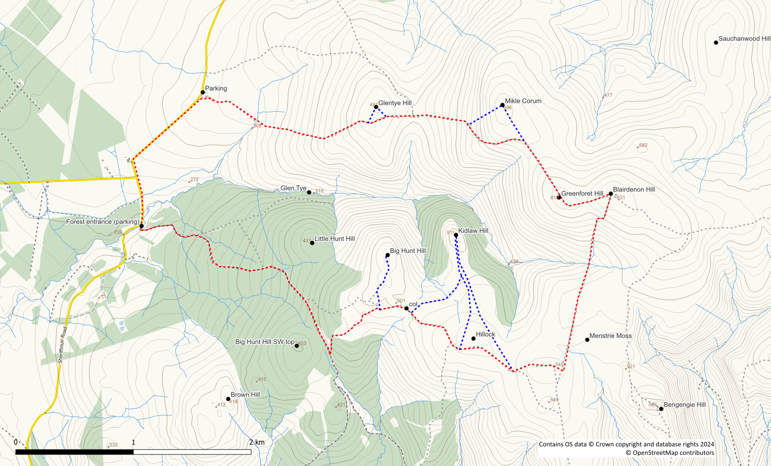
Cross the bridge into Jerah forest and follow the track in a roughly southeast direction for just over 2km. Although not the most auspicious of starts to a walk, at least it is an easy means of gaining altitude. The track is predominantly uphill until it levels out at around 430m. As the track starts to descend, bear sharp left onto an obvious stony path. This short section of path leads uphill to a gate and stile onto the open hillside. After passing through the gate the path becomes a grassy ATV track continuing uphill. At approximate grid ref. NN 845 009 the main track bears right and a trodden path heads north to Big Hunt Hill. If you choose not to include Big Hunt Hill, stay on the ATV track. Continue to follow it in an easterly direction to the 496m col marked on the OS Explorer map.
To include Big Hunt Hill, simply follow the trodden path for 500m through long tussocky grass to reach the 521m summit. Either return the same way back to the ATV track or take a more direct southeast line to the 496m col and re-join the track there.
The ATV track now continues in a roughly southeasterly direction to pass to the south of a 541m hillock. Stay on the main ATV track in an easterly direction aiming for Menstrie Moss. The ground is now more mossy and wetter.
The 510m Kidlaw Hill can be included by striking out northwards across tussocky pathless ground. Leave the ATV track at the 496m col following the 500m contour line. Or continue on to the 541m hillock and head north from there. There is little in the way of path although bits of ATV track may be utilised at times. A fence needs to be crossed on route to the hill. After Kidlaw Hill return south (or southeast) to rejoin the ATV track.
The ATV track continues its easterly route until veering right just before a fence is reach. At the fence turn left (northwards). Follow the path/track alongside the fence with the peat hags of Menstrie Moss to your right. The path descends steeply into a gully with a burn where a fence needs to be crossed. After a section of eroded path the path crosses the burn and ascends the southern slope of Blairdenon. Continue upwards on the path roughly alongside the fence to reach the 632m summit at a junction of three fences. A couple of stiles enable easy access over the fences to the summit.
From Blairdenon it is an easy walk on trodden path/ATV track to the 616m summit of Greenforet Hill. On route a small memorial cairn to a 1957 air crash in the area is passed. At Greenforet the fence and track turn sharp right and continue northwest passing the summit. After about 600m a trodden path leads off to the left downhill back to the Sherifmuir Road.
It is worthwhile continuing on the ATV track for a further 400m to include the 594m summit of Mikle Corum. From here, you can return along the ATV track back to the trodden path. Alternatively, head directly down the hillside to join the path further down.
The obvious path descends easy slopes to a col and a deer fence. A pedestrian gate in the fence affords easy access to the eastern side of Glentye Hill. The path continues up and over the southern shoulder of Glentye Hill bypassing its summit.
Glentye Hill can be included with very little extra effort. Its 481m summit lies less than 100m off the path to the north.
The trodden path now provides an easy descent through new forestry plantings. The forestry area is exited by passing through another gate in a deer fence. A stand of trees at the side of the public road is the next landmark. After passing through the trees join the road and turn left. From here, it is a downhill road walk for about 1.2km back to the start point. Bear in mind that if you do the route in reverse you will have to walk up the road!
