A walk to two quiet Ochils summits. Due to the nature of the terrain this walk is better suited to regular hillwalkers comfortable with off-path walking. Navigation skills may be required if visibility is poor.
- Distance: 10 km / 6.2 miles
- Ascent: 430 m / 1400 feet
- Terrain: Mostly path-less ground on tussocks and heather. Some fence climbing required.
- Start / finish: Layby on A823 opposite Glendevon Reservoirs road, north of Glendevon, grid ref NN 948 052
Route Map
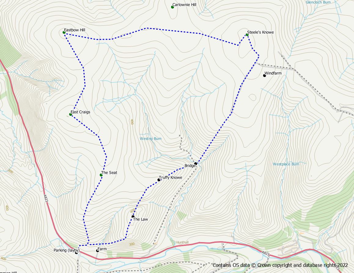
Climb the fence at the north end of the layby into the adjacent field and start making your way up the hill alongside the trees. At the far side of the field a gate leads out onto the open hill. Make your way uphill in a roughly northerly direction over grass tussocks and heather. This section of the walk can be hard work as previous quad bike tracks are no longer in existence.
Aim towards the summit named The Seat. You may be able to pick up other tracks to follow but take care to ensure that they are heading in the right direction, especially if visibility is poor. After The Seat continue northwards for a further 500m before bearing left towards the summit of East Craigs 600m north west.
There are two cairned summits and the second one is the highest point at almost 471m. To avoid losing height, leave the summit in a north north east direction aiming towards a coll 500m distant. Turn north west at the coll aiming towards the summit of Eastbow Hill. The terrain here becomes a bit rougher over tussocks although you may be able to pick up a quad bike track to ease progress.
Eastbow Hill at 476m sports its own OS trig point to mark its summit. The route from here to Steele’s Knowe is almost due east following the wall / fence for over 2km. The terrain is easier now although it can be quite wet in places. Part way along a new deer fence puts in an appearance. If you wish to make a detour out to the summit of Carlownie Hill from this direction then it is necessary to climb the fence. If you are heading for Steele’s Knowe stay to the outside of the fence for now with the windfarms ahead of you.
The 485m summit of Steele’s Knowe lies to the north of the walll/fence and deer fence. Fortunately there is a pedestrian gate in the deer fence to make access to the summit straightforward. However, there is no gate/stile over the old fence and if you don’t want to climb this, then walk on for a bit until you reach a cattle grid on the windfarm road which you can use to cross the fence (you will then have to walk back to the deer fence gate).
From the summit return to the wind turbine closest to the deer gate. From here follow the road south south west for 800m to reach turbine no. 1 (don’t be tempted to follow the exit sign).
At turbine 1 leave the road on a feint path heading downhill in a south westerly direction. Either follow the path/quad bike tracks or make your own way down the hillside aiming for a confluence of two burns and a wooden shooting hut. Cross the burn on a wooden bridge (or use the ford) and follow the track south west up the hillside.
When the track comes to an end continue south west up the grass slopes of Truffy Knowe. Cross a fence after which the terrain becomes a bit more tussocky / heathery until you reach the flat summit area. Continue south west downhill until you start to approach a fence. At this point turn south and then south east for the summit of The Law. This dog leg avoids descending and reascending steep ground at The Goat.
The Law at 404m is the last summit of the day. It’s an unremarkable summit without any feature. From here it is now all down hill. First though, head to the 393 point south of the summit. Descend south west towards Glenhead Farm. A fence needs to be crossed and unlike the earlier fences this one includes a barb wire strand. After the fence it is a straightforward descent on a quad bike track down to the farm.
Follow a path round the back of the farm and make your way along the hillside beside the walls to reach the stand of trees close to where you started. Climb the gate and cross the field back to the road.
An alternative is to miss out Truffy Knowe and The Law. After crossing the burn at the shooting hut, walk along the landrover track (dodging partridges) around the eastern side of the the hills roughly parallel to the Hillkitty Burn. This track will take you to Kaimeknowe and the main road. Unfortunately from here is is a 10 minute walk along the main road (without pavement) back to the start point. Take extreme care as this road can be busy.

