Glensherup Round
A high level circular walk around the Glensherup reservoir nestled in the Ochils Hills. The walking is primarily on grassy paths but navigation skills are strongly advised if visibility is poor. You should also ensure you are adequately equipped for a day in the hills.
- Distance: 15 km / 9.3 miles
- Ascent: 650 m / 2100 feet
- Terrain: Mostly grassy hill paths
- Start /finish: Woodland Trust Glensherup car park on the A823 to the north of Glendevon grid ref NN 971 051.
Route Map
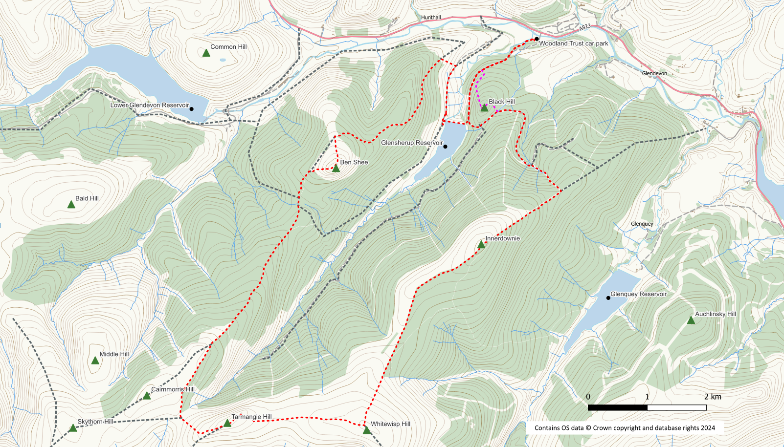
From the western side of the car park pick up an obvious path which links to the forest track network. Head southwest then south on the track as it circles Black Hill. At a junction keep left uphill and follow the track in a northeast direction around the tree clad hill.
If you wish to include Black Hill in your walk this is easily done by using a mountain bike trail up the nothwest side of the hill leaving the forest track at grid ref NN 966 047. The rough trail takes you easily uphill between the mature conifers with no difficulties. The summit is not marked and there are no views due to the trees but it is a very obvious spot. Descend northeast on a further mountain bike trail which soon bears east to join the forest track on the east side of Black Hill where you should turn left.
This track curves its way up the hill initially to the right around Gled’s Nose and then to the left. At grid ref NN 971 039 where the track bends left take a rough path on your right hand side beside a small burn. This path is initially quite steep and may be muddy in places. The gradient does ease though and it provides a delightful walk up through the trees culminating in a high stile to reach the open hillside.
Turn right on to the open hill and follow a grass path up hill which will eventually bring you to the summit of Innerdownie Hill. There is a rock shelter here for coffee/lunch stop, just beyond the summit.
After Innerdownie it is a straightforward walk along the ridge with a fence to follow, to the summit of Whitewisp Hill with its small cairn. From Whitewisp head in a westerly direction to Tarmangie Hill to regain a fence line. The descent from Tarmangie is initially south west and then steeply north west to the head of Glen Sherup again close to a fence. From here the path now turns northerly and north easterly on to Scad Hill before gently descending to a bealach.
There is a signpost at the bealach and if you don’t feel like tackling Ben Shee in front of you, you can take the right hand option following a path followed by a track down into Glensherup. Follow the track along to the dam where you can rejoin the route described below.
After the bealach the path which has now become more of a track starts to go back up hill to pass to the north east of Ben Shee. However, at the highest point you can strike off up a rough path to reach the summit of the hill. Make your own way down the north west slope of the hill to rejoin the track.
The track continues to lose height through newly planted woodland. After going through a gate you should turn immediately right off the track to follow a rough path alongside the fence. This path will bring you out on to the reservoir access road. Turn right and go past a house until you reach the dam.
A path leads down to the dam and you can walk across the dam wall. At the other side a steep path leads up into the forest to join the forest track that leads back to the car park. Turn left on to this track to return to your start point.
