Hills: Cullaloe Hills (219m), Pilkham Hills (194m), Templehall Hill (167m).
The Cullaloe Hills is the name given to the upland area to the north of Aberdour. Clad in both mixed woodland and forestry plantation, with their northern slopes eaten away by quarry workings, they would be fairly non-descript if it wasn’t for the two follies (Cullaloe Temple and Culllaloe Tower) to be found amongst the trees. Reaching the follies is easy enough from the north east side but there are also other walking opportunities for the walker who doesn’t mind a bit of rough ground and mud.
Today, the Old North Road is the name given to the route from Dunearn (Stenhouse) to Mossmorran. Historically this would have been part of a route from Burntisland northwards. Cullaloe Hills, Pilkham Hills and Templehall Hill (along with Montquey Hill and Dunearn Hill) are short detours off The Old North Road.
A circular route taking in the Old North Road, Cullaloe woods and Otterston area is described below. Also suggested are a couple of short routes exploring the Cullaloe Follies.
2024 Update
Recent quarrying has permanently altered the summit of Cullaloe Hills. The highest point listed in the Database of British and Irish Hills no longer exists. There is also new fencing making access to the summit ridge a little tricky.
2025 Update
Storm Eowyn has caused considerable devastation in Cullaloe Woods to the east and southeast of Cullaloe Temple. The previously described (almost) circular route from Cullaloe Nature Reserve is unlikely to be viable for the immediate future and its description has been removed from this page.
Old North Road and Cullaloe suggested circular route
A number of options for a circular route taking in both the Old North Road and the Cullaloe Hills are possible.
- Distance: 16 km / 10 miles
- Ascent: 360 m
- Terrain: Very mixed from easy coastal path and quiet roads, to swampy ground along The Old North Road. Walking boots essential for the wetter parts and gaiters recommended.
- Start/finish: Aberdour
Route Map

NB: viewpoints marked on above map have been lost to quarrying
Starting from Aberdour head out of the village on the road towards Burntisland. Outside of the village a sharp right hand corner is reached. At this point take extreme care and cross over the road to join the farm track on the left hand side. Almost immediately turn right onto a path signposted for Dunearn. Keep to this path uphill through the woods (can be overgrown) and then across fields with views out over the Forth, to reach Dunearn.
A longer option is to head out of Aberdour along the coastal path to Burntisland. On reaching Burntisland head to the start of the “gorse path” at NT 2202 8665 on the A909 (various options are available). From here follow the gorse path up to the Standing Stane road at Dunearn.
Cross over the busy road (assuming you have approached from the Aberdour track) on to the quiet Standing Stane road opposite. 100m along the road on the left hand side is a new gate into a field providing access to the core path route to Stenhouse Reservoir. Cross the field (don’t go up to the stile) then pick up another path to the reservoir through a wooded area. From here either walk around the reservoir (optional) or turn left to the road (climbing over a gate) and then walk down the obvious access road for the cottages (old fishery road). At the fork in the road, go left up to the cottages and then follow this track (part of the Old North Road) over fields to reach cottages and a farm at Balmule on the B9157.
Cross over the road and follow the quiet road opposite, up to Puddledub. Where the current road turns sharp right, a signpost for the Old North Road points left. Follow this sign along the track past the cottages.
For the hill bagger there is an optional ascent to Templehall Hill from this point.
Continue on along the track veering left through a pedestrian gate onto a grassy path. After another pedestrian gate the path enters woodland and starts to become somewhat wet underfoot. There is some boardwalk in the wetter sections and Scotways markers to help with the route finding. After the Scotways markers are some old marker stones though now covered in moss. Cross a stile and continue on the path through the woods with fields to your left. Look out for a large standing stone (also used as a gate post) on your right hand side. At this point the route of the Old North Road turns right out to Mossmorran.
For the hill bagger there is an optional ascent of Pilkham Hills and the associated trig pillar from this point.
Keep straight on, on the south side of the wall (leaving the route of the Old North Road) and follow the route of the path through the woods which starts to become a wider grass track. Keep up high until the woods are exited and the path winds its way down the hill to a sheep fank where a stile can be used to reach the road.
Cross the road to reach the forestry entrance opposite. The easiest walk now is to stick to the forest track but diversions through the woods to Cullaloe Tower and the crest of the hills are possible. Keep with the main track for about 1km to reach an open area. At this point there is the option to double back on the right hand side to make a detour to Cullaloe Tower (about 1km there and back). Continuing south west, Cullaloe Temple is soon reached. An alternative is to use a rough trodden path directly to Cullaloe Tower. This path starts on the right hand side of the forest track at approx. NT 186 887. From Cullaloe Tower there is a wide grassy firebreak / path to the open area before Cullaloe Temple. The path then continues south west along the rim of the old quarry, making its way downhill to reach a road. Towards the end of this path there are currently (March 2025) a number of fallen trees that have to be negotiated either by climbing over or going around.
Turn right on to the road for 50m to reach the next turning on the opposite side of the road where a new house has been built. Turn left on to the farm track following it along field edges beside the woods. Keep to the line of the woods on a rough path. Cross over a field track and pick up a rough path through the woods in a roughly southerly direction. At the bottom end of the woods to the left is Mount Laura Tower a 19th century lookout tower. The path makes it’s way out to a quiet road. Turn left on to this road walking downhill passing Otterston Loch. After 1km the road passes under the railway and meets the main road.
Cross over the main road and turn left on to the pavement on the opposite side for almost 500m. At this point, the quickest way back to Aberdour is to walk along the pavement following the road. However, a better route is to turn right at the roundabout towards Braefoot Terminal. 700m down this road the route of the coastal path crosses the road and can be used to walk back to Aberdour. An alternative would be to cut off the corner by using a field edge path to Downans Plantation and join the coastal path from there.
Cullaloe Hills and Follies
There are three normal points of access to the area:
- Layby on the B9157 opposite Cullaloe Nature Reserve. Grid ref NT 186 877.
- The forest track entrance on the A909 to the north east where there is room to park 2 – 3 cars. Grid reference NT 187 890.
- The gate at the south side where there is not really any suitable parking though you may be able to squeeze 1 car in. Grid reference NT 173 864.
From Cullaloe Nature Reserve
Opposite Cullaloe Nature Reserve, there is a field access track heading up the hills. The track starts about 50m north of the layby, towards Kirkcaldy. A gate has recently been installed at the start of the track which may need to be climbed.
Once on the track follow it across the fields to reach a woodland area, and then around the field edge. Don’t be tempted to short cut across the field whilst there are crops growing in it and keep dogs away from the crops. The track enters the woodland and reaches some broken wooden gates. At this point leave the main track turning left onto a grass track through an open metal gate – ignore the main track which goes right at this point. As the path reaches the edge of the woods, turn right on a trodden path through the trees to reach a metal gate. Climb the gate and cross a rough field to reach another gate (probably open).
Once though the second gate head up the hill aiming for a fire break. When a concrete block/drain is spotted to the right, head away from the firebreak by going left on a rough path. Proceed roughly south westerly until the path reaches a fence and bears right. The path can be hard to follow in the summer when it is overgrown but if in doubt follow the fence line uphill. The path meets with the main forest track.
Turning right at this points takes the walker to the interesting folly of Cullaloe Temple. After the temple continue in a north east direction to reach a Y junction. At this point follow the left hand fork to the 2nd folly of Cullaloe Tower via a grassy and sometimes wet path.
After the tower, there is a rough trodden path northeast down hill back to the main forest track. If not comfortable with this path then simply return back to the Y junction from Cullaloe Tower.
From Cullaloe Forest Entrance (easy option)
- Distance: 3 km
- Ascent: 50m
- Terrain: Forest tracks and grass track
- Start / finish: Forest entrance at NT 187 890 on the A909.
If you want an easy walk to the follies, then start from the forestry gate on the A909 south east of the Beverkae Roundabout and walk along the main forest track to Cullaloe Temple. After viewing the temple walk back in the direction of the parking area but keep left at a Y junction. A grassy track heads to the 2n folly of Cullaloe Tower. The easiest option from Cullaloe Tower is to retrace your footsteps to the Y junction. An alternative is to follow a rough trodden path northeast from the tower. This rough path heads downhill to meet with the forest track. Turn left to return to the parking area along the forest track. This walk is just 1.8 miles with less than 100m of ascent. The majority of the walk is on surfaced forest track although the detour to Cullaloe Temple is on a somewhat damp grassy path.
If starting from this point, please do not block the forestry gate as access may be required for large vehicles. There is only parking for about 3 cars without blocking the gate.
Cullaloe Hills summit
Sadly the crest of the hill has been quarried away and currently the highest point lies within the fenced off quarry area with plenty of keep out notices. The highest point that is not within the fenced off area can be reached from Cullaloe Tower by heading up the steep bank to the fence line. Walk along the crest beside the fence though this can be a bit awkward with a steep drop on one side and the quarry fence on the other.
The true high point is currently within the quarry area at NT18120 88440 and is probably about 218m.
Alternative Access
Access is also possible from the Crossgates to Aberdour road at NT 173 864. From here a there is a path through the woods alongside the disused Goathill Quarry, that meets the forest track at Cullaloe Temple. However, fallen trees in February 2025 need to be negotiated at the start of the path.
Route Map of Cullaloe Hills area
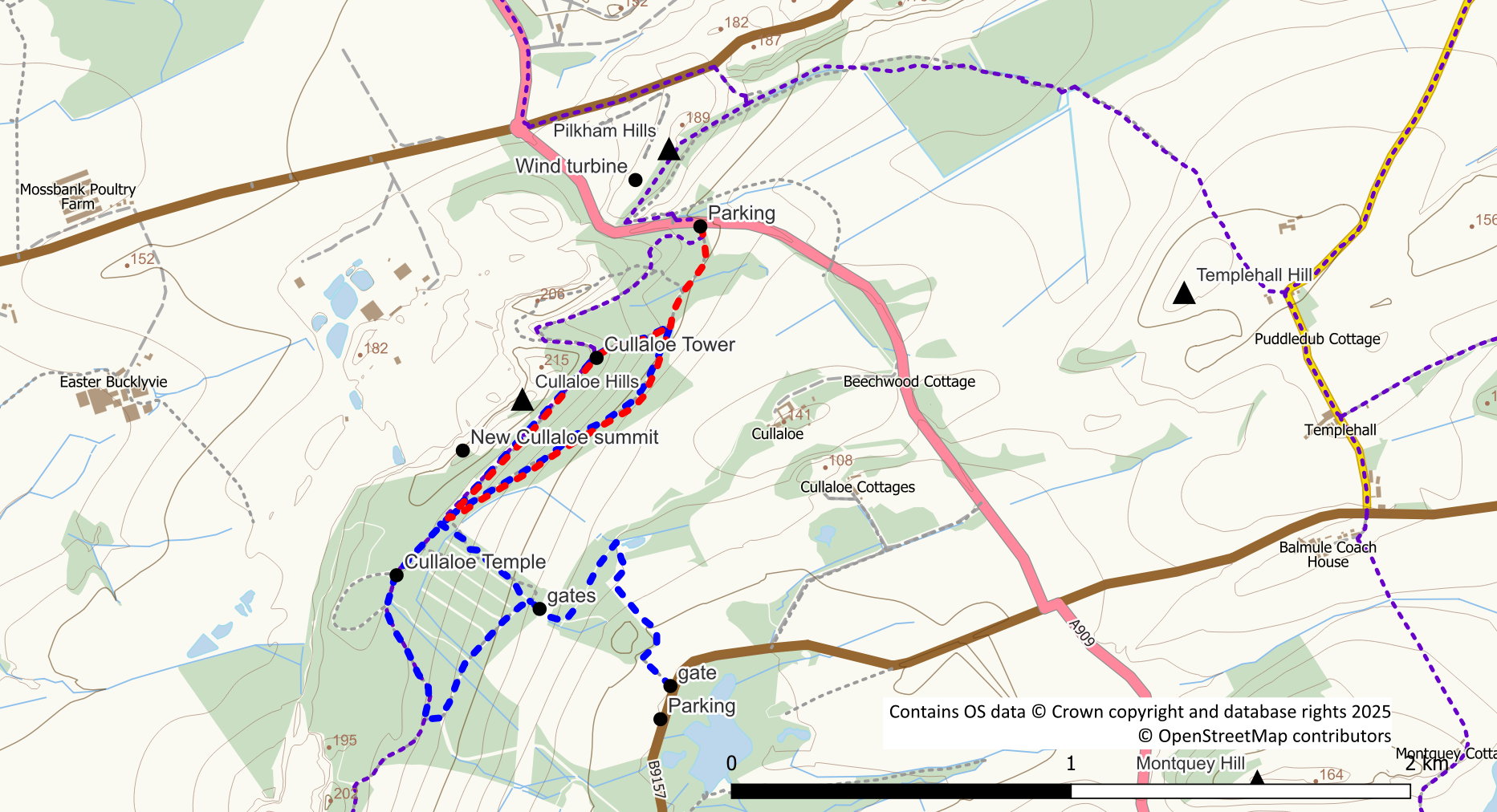
Red and Blue: Cullaloe routes; purple: core paths
Pilkham Hills
Across the A909 road from Cullaloe is the 194m high point known as Pilkham Hill. A stile and a signpost for the Old North Road indicate the start of the route almost directly opposite the forest entrance. Reaching the Pilkham Hills is easy (easier than Cullaloe). After crossing the stile, follow the grassy track uphill. Leave the path going up through the easily negotiated tress towards the area of the wind turbine. Once out of the trees it is a grassy walk across to the high point. From here it is also possible to visit the trig point on the other side of the B925. A track and gate makes access out to the road straightforward. Once over the road there is a bit of a path to the trig avoiding the gorse bushes.
Templehall Hill
Templehall Hill lies at the southern end of this section of the Old North Road close to where the path rejoins the public road at Puddledub. The hill summit is in a grassy pasture field and is easily reached from the path via an openable gate at NT 20085 88961. From here it is an easy walk following the fence line, and a sheep path through the gorse, to reach the summit.
