Hillfoots Trail
This 15.7 mile route can be walked either as a complete route or conveniently split into two shorter sections. The full route runs from Logie Kirk on the outskirts of Blairlogie to Pool of Muckhart. It utilises parts of the waymarked routes of the Hillfoots Diamond Jubilee Way and the River Devon Trail, but also includes some additional non-waymarked sections.

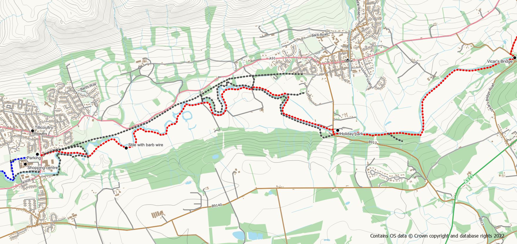
Hillfoots Trail Section 1
Logie Kirk to Tillicoultry
- Distance: 13 km / 8.1 miles
- Ascent: 300m / 990 feet
- Terrain: Paths (unsurfaced), tracks and quiet road
- Start: Logie Kirk, Blairlogie, off the A91 (NS 817 966)
- Finish: Tillicoultry (Sterling Mills, Moss Road) (NS 920 966)
- Facilities: Parking at Logie Kirk (not Sunday’s) and Devon Way car park in Tillicoultry. There are regular bus services between the start and Tillicoultry. Refreshments available in Tillicoultry.


The route starts at Logie Kirk where a footpath heads eastwards around the church yards and across the fields passing behind the caravan site. After just 1km the path reaches the small village of Blairlogie and the route passes through the village on the obvious roadway. After the houses, go through a pedestrian gate on to the next section of footpath and follow it through the woods passing a small car park area. Keep to the footpath route contouring around the hillside and cross a small footbridge before joining an obvious track. Turn left on to the track and follow it uphill for about 700m until a cottage / farm is approached. At this point, go left onto a footpath which has been constructed so as to bypass the farm buildings. There are some good views over the Forth Valley from this area. This section of path bears left around the hillside and rejoins the track. Go left on the track for a short distance until an obvious gate on your right is reached. Go through the gate and follow the path (steps have recently been constructied) steeply downhill beside a covered reservoir and out to the road in Menstrie
From Menstrie the easiest route, and the one used by the Jubilee Way, is along the back road to Alva. This is a quiet road walk of 3.5km to reach the entrance to Alva Glen.
An option is available to miss out part of this road by using a very overgrown and rough path at the back of Menstrie. However, this is not a particularly easy route and may be impassable during the summer months. To follow this route turn left off Ochil Row heading up the “pony track” towards Myretoun Hill. At the first zig zag take a trodden path to the right heading eastwards along the foot of the hills. On reaching an obvious pedestrian gate turn right before the gate and follow the fence line on a very rough, slippy and over grown path until a wooden gate is reached. This awkward gate needs to be crossed, after which it is necessary to find a route down the steep hillside, crossing the burn, to reach the edge of woodland. Cross the broken fence into the woodland and make make your way easily through the trees to reach a wooden gate out to the road. From here use the road to reach Alva Glen
On reaching the bridge over the burn at Alva, turn left following the green Path sign to Alva Glen. There are multiple paths here and it doesn’t really matter which way you choose. The route signed for the Jubilee Way, crosses the burn and goes up the hill , skirting the back of the old mill building. Follow the network of paths up the hillside above the burn to reach the remains of an old pipe. An alternative means of reaching this point is by using the lower paths through the glen and taking in the waterfall before following the path up the hill through the trees. From the pipe head up the hillside turning right when a Scottish Water compound is reached. A footpath now crosses the steep grassy hillside at the back of a farm to join the zig zag track up the Silver Glen. Turn left on the track for a short distance until another grassy path goes right to a pedestrian gate at the edge of the Ochils Woodland Park.
The route now makes its way to Tillicoultry via the pleasant woodland park. There are two routes through the park, the high route and the low route, either of which can be used. The two routes merge on the outskirts of Tillicoultry when the golf course is reached. Continue on the obvious path/track as it follows the edge of the golf course and bears rights before reaching the main road at the western edge of Tillicoultry.
Cross the road and turn right for a very short distance to reach the entrance to the public park on your left. Head into the park and walk to its south eastern corner. Exit the park via a footbridge over the burn. Cross over the road and turn right passing houses to reach a rough field to your left. Follow a rough grass path across the field to the obvious end of the railway embankment where the bridge of the River Devon has been demolished. Pick up a trodden path eastwards along the bank of the river on the route of what is now the River Devon Trail. Keep to the path until an obvious tarmac track is reached at a bridge.
The River Devon trail continues straight on here skirting the back of the shopping centre. However, for ease of splitting the route into two sections turn left on to the track which is part of the Devon Way cycle route. Follow this tarmac track past the waste water works and round to the right to reach the Devon Way car park.
Hillfoots Trail Section 2
Tillicoultry to Pool of Muckhart
- Distance: 12.3km / 7.6 miles
- Ascent: 200m / 660 feet
- Terrain: Mostly unsurfaced trodden paths which can be muddy. Small amount of track walking.
- Start: Tillicoultry (Sterling Mills, Moss Road) (NS 920 966)
- Finish: Pool of Muckhart, Coronation Hall (NN 999 006)
- Facilities: Parking at Devon Way car park in Tillicoultry and on the street in Muckhart. Occasional bus service between start and finish. Refreshments available in both Tillicoultry and Muckhart.
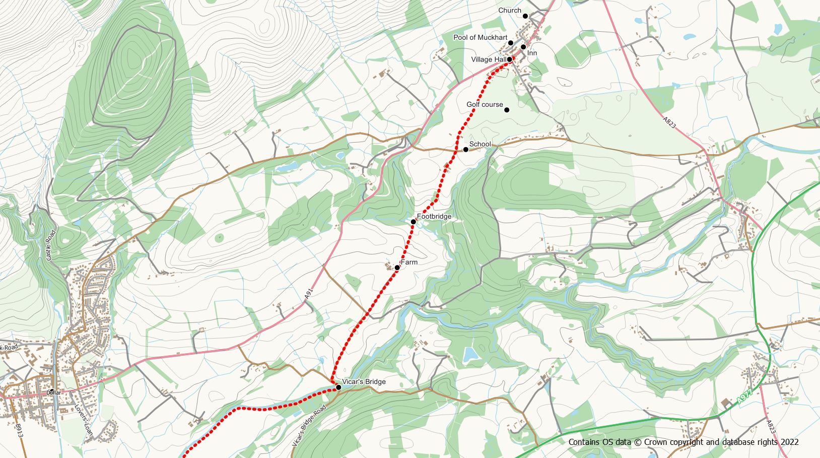
From the small car park cross the main road and follow the cycle route signs on the opposite side to pick up the Devon Way cycle track. This route will itself take you to Dollar but it is hard surface tarmac walking for the entire distance. A more walker friendly route is to leave the hard surface using a trodden path running parallel to the cycle way on the right hand side. However, this path itself forks and the most scenic option is to to take the right hand fork along the banks of the River Devon. The paths between here and Vicar’s Bridge can be somewhat mucky underfoot after rain so best to wear proper walking boots for this section. Follow the riverside path until the first bridge is reached. Cross to the south side of the river and pick up a further trodden path following the twists and turns of the river along it’s southern bank. There are lovely views over the river to the nearby Ochils Hills for most of this section. A fence with an awkward barb wire stile needs to be crossed but this is the only difficulty likely to be encountered along this stretch. 1.6 km from the stile a second bridge over the river is reached. Keep to the southern bank still on an unsurfaced trodden path (an alternative path follows the northern bank) to reach a third bridge on the outskirts of Dollar. This time cross the river to its northern bank and follow the trodden path around another river bend and out to the road south of Dollar.
Take care crossing the road, cross over the bridge and pick up a sign posted trodden path on the southern bank. This section of the route is part of the River Devon Trail and occasional waymarker arrows will be spotted in the woods. The railway line is passed once again, where a now dismantled bridge used to carry it over the river. Ignore the railway, and keep to the trodden path on the southern side of the river for a further 1.8km to reach the vicinity of Vicar’s Bridge. At this point the path becomes a track which can be followed out to the road. Turn left on to the quiet road and follow it past a memorial stone down to the modern Vicar’s Bridge. The Alloa Advertiser carries an interesting story of an 1865 murder of the local bakery delivery driver in this area.
After the bridge, take the first right turning on to a further quiet road. Walk up this road for about 600m to reach a crossroads and a footpath signpost. Go straight on at the crossroads on the “old road to Muckhart” towards Cowden Farm. After the farm a track continues down the hill to reach a ford where a wooden footbridge can be used to avoid getting wet feet. Once across the river, the route heads sharply uphill across the grassy field passing a stand of trees. After the hill a pedestrian gate is used to exit the field to reach The Leys. Follow the track out to the road, cross the road, and pick up the signed path opposite. This final section leads pass the golf course to reach the small village of Pool of Muckhart.
