The two high-points of Bandrum and Bonnar Knoll are located south of Saline on either side of the B913 road and link together well.
Bandrum at 225 m has the distinction of being classified as a Tump (hill with 30 m or more all round drop/prominence). Close to the hill are the attractions of the Bandrum Standing Stone and Bandrum Temple, a lookout tower dating back to the 1840’s, which are both worth a visit. The summit of Bandrum is part of Saline Golf Course so be wary of golfers when approaching.
Bonnar Knoll is perhaps Fife’s newest “hill”. This artificial mound has been formed from previous open cast mining. However, now that mining operations have ceased the area is being regenerated and planted with trees. It’s a quiet area that hopefully in future years will return to a more a natural environment provided it remains off the radar of developers, unlike its counterpart at St Ninians. 141 m is the current OS recognised height however, it is probably nearer 142 m (from Scottish Government phase 5 LIDAR DTM data). Unfortunately the hill doesn’t have quite enough prominence for it to qualify as Fife’s newest Tump but it comes close.
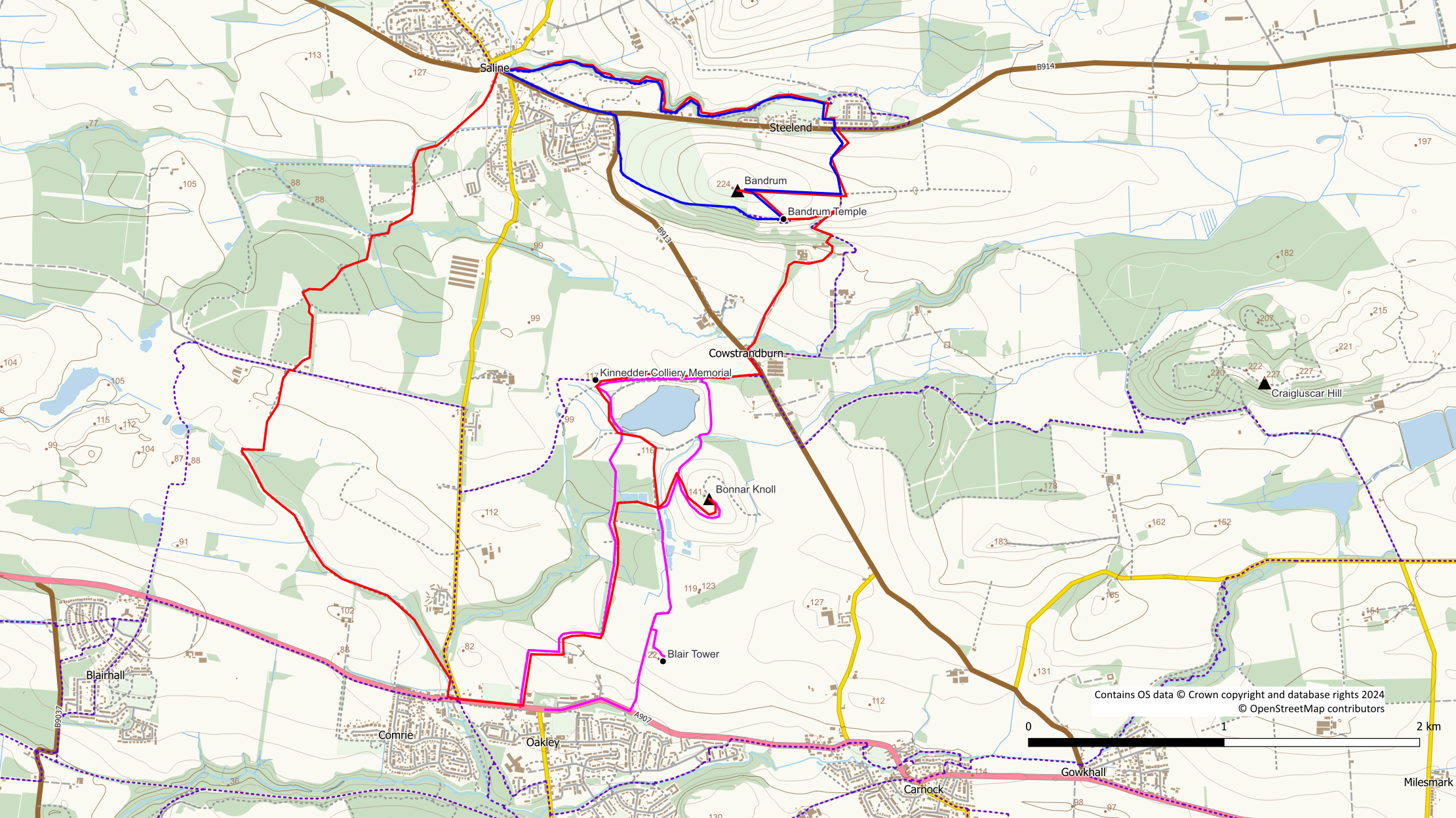
Blue: Bandrum Temple and Saline Glen circuit; Magenta: Bonnar Knoll and Blair Tower; Red: Bandrum and Bonnar Knoll; Purple dots: core paths.
Bandrum (225 m)
The easiest approach to the hill is from Saline or Steelend but it is also possible to walk in from Cowstrandburn.
From Steelend a signposted (for Cowstrandburn) track starts at NT 039 921. After 350 m, having passed through a gate, leave the track through a gate on your right. Follow the field edge (livestock may be present in the field) to the far side to reach the Bandrum Standing Stone, a large boulder at the corner of the wall. Squeeze through the fence where the barb wire has been removed and follow the wall to reach the summit complete with bench.
From Saline, head down the B913 for 180 m (no pavement) to reach a gate at the edge of the golf course on your left hand side. This is the start of a track / path round the outside of the golf course to Bandrum Temple. From the Temple you can squeeze through the fence and cross the field to the north west corner with the standing stone and hence on to the summit. Alternatively stick with the path to skirt the edge of the field and join the Cowstrandburn to Steelend track. Follow the track round to the left until the track passes through a gate. At this point go left into the fields and follow the field edge to the standing stone.
Bonnar Knoll (141 m)
Access to this area is possible from Oakley to the south using the forestry access track past Blair Tower. Also from Oakley is a route using the road into Blair House. Before Blair House turn left onto a grass track followed by another left turn on to a trodden path through Black Wood woodlands.
An alternative route of access which links well with Bandrum Hill is from Cowstrandburn to the east on a signposted core path. Leave this path close to the Kinnedder Colliery memorial heading south on a stony track towards the mound of Bonnar Knoll. This core path can also be walked from the west from Kinnedder.
At the foot of the hill a high deer stile needs to be climbed (the adjoining gate is likely to be locked). A rough trodden path then heads up the hillside to meet with an obvious track. Turn right on to the track and follow it to the summit area. The summit itself has been planted with trees.
Suggested walks in the area
Bandrum Temple and Saline Glen circuit
- Distance: 5 km / 3 miles
- Ascent: 150 m / 500 feet
- Terrain: Tracks/paths/field edges/some hard surface – may be muddy and eroded in places
- Start / finish: Steelend (or Saline)
Start from Steelend using the signposted Cowstrandburn track to the south. To make a detour to the standing stone and summit leave the track at its high point where it passes through a gate. Go right into a field (livestock may be present) and follow the field edge to the Bandrum Standing Stone. From here squeeze through the fence on to the golf course and follow the wall to the summit. Return to the standing stone and walk round the field to the temple. Squeeze through the fence a the temple back on to the track.
Without the detour, keep to the track until a signed path leads off right up some steps toward the temple. Follow this path past Bandrum Temple and along the edge of the golf course until it joins the main road. Turn right on to the road and walk back to Saline (there is no pavement at this point), Turn left at Saline and walk through the village until the obvious entrance to Saline Glen (on the right) is reached.
Walk along the path through the glen beside the burn with its tumbling cascades and waterfalls. There is some erosion on the path in the area where a pipeline crosses the burn and care should be taken. It is possible to avoid some of the erosion by walking up out of the glen to a rough grass area. However, when the path nears the road it will be necessary to descend back into the glen unless you want to walk along the road. The glen path passes around some houses and there is further erosion. Once past the eroded parts, the path improves as it approaches Steelend and exits the glen on to playing field.
Cross the field aiming for a gate on the far side next to the Miner’s Welfare.
This walk is shown in blue on the map.
Bonnar Knoll and Blair Tower circuit
- Distance: 6.1 km / 3.7 miles
- Ascent: 100 m / 330 feet
- Terrain: Tracks (stony) and paths – may be muddy in places
- Start / finish: Oakley
A pleasant short circular route of Bonnar Knoll taking in Blair Tower is possible from Oakley. Commence the walk on the forestry track starting at NT 029 893 to the north of the village. It’s worth making a detour to the tower which can be reached by field edges and a trodden path. Return to the track and continue to a green barrier gate at the entrance of the forestry area. From here a stony track passes through new tree plantings to an obvious track junction. To the right is a high deer stile that gives access to the hill area. Proceed up the hill on the rough trodden path and turn right when it meets with an obvious track. The track winds its way up the summit area. The actual summit is a bit rough as it has been planted with trees.
From the summit return in the same direction but staying on the track when the trodden path heads left. Head down the track towards an artificial pond. Pass through a pedestrian gate followed by a short section of track. On reaching the pond keep right on a trodden path, to the side of a pedestrian gate. Follow the path around the eastern side of the pond until it meets with the core path from Cowstrandburn. Turn left on to the trodden path around the north of the pond, detouring slightly to reach the Kinneddar Colliery memorial.
Return to the main track and head south on the stony track to an obvious track / path junction. Go right through the pedestrian gate heading slightly uphill to reach a 2nd gate leading into woodland. From here there is a pleasant woodland path through Black Wood back to Oakley. On approaching Blair House on the outskirts of Oakley, turn right on to a grassy track and then right again on to a surfaced road.
This route is shown in magenta on the map.
Bandrum and Bonnar Knoll circuit
Saline makes a good start point for this longer route but other options are possible. The walk starts at the entrance to Saline Glen on the main street, close to a parking area.
- Distance: 13 km / 8 miles
- Ascent: 290 m / 950 feet
- Terrain: Tracks, paths (some unsurfaced and potentially muddy), some short sections of hard surface walking.
- Start / finish: Saline (Steelend and Oakley are also possible starting points)
Walk through the glen on a sometimes muddy path beside the burn with its tumbling cascades and waterfalls. There is some erosion on the path in the area where a pipeline crosses the burn and care should be taken. It is possible to avoid some of the erosion by walking up out of the glen to a rough grass area. However, when the path nears the road it will be necessary to descend back into the glen unless you want to walk along the road. The glen path passes around some houses and there is further erosion. Once past the eroded parts, the path improves as it approaches Steelend and exits the glen on to playing field.
Cross the field aiming for a gate on the far side next to the Miner’s Welfare. Go left on to the road and then immediately right. Cross the main road and follow the signposted (for Cowstrandburn) path on the south side. This track takes the walker directly to Cowstrandburn. However a detour can be made to visit the summit of Bandrum Hill (on the golf course), the Bandrum Standing Stone and Bandrum Temple. When the track passes through a gate at its high point, turn right through a gate into a field (livestock may be present) and follow the field edge to the far side. The Bandrum Standing Stone is the obvious large boulder at the corner. Squeeze through the fence on to the golf course (watch out for golfers) and follow it to the summit of Bandrum. Return to the standing stone and walk round the field to the Temple where it is again possible to squeeze through the fence on to the path. From the Temple go left on the path to rejoin the track and turn right downhill.
Continue on the track downhill until a pedestrian gate with a signpost on the right is reached. Follow this signed path downhill through the trees to the back of the Bandrum Care Home (which has a community cafe). From here, follow the driveway out to the main road and turn left. Cross over the road and pick up the trodden core path on the opposite side signed for Kinneddar.
Keep to the main path passing an artificial pond (remains of the opencast mine) enclosed by a deer fence. Stick with the path when it leaves the fence and heads uphill to reach a memorial for the Kinneddar mine disaster. From this point go downhill to join a stony track around the west side of the pond. Keep to the track, away from the pond, as it makes its way south towards the mound of Bonnar Knoll. On the west side of the hillock a junction leading to a deer gate and large stile is reached. To include Bonnar Knoll go left here over the stile. A rough trodden path then heads up the hillside to meet with an obvious track. Turn right on to the track and follow it to the summit area which has been planted with trees. From the summit return back to the stile.
On returning to the track junction at the gate / stile, keep straight on passing artificial ponds on the right. After the ponds, turn left onto a woodland path. This is now a pleasant woodland route through Black Wood to Oakley. On approaching Blair House on the outskirts of Oakley, turn right on to a grassy track and then right again on to a surfaced road.
On reaching the road at Oakley go right for about 350 m to the White Gates pub in Comrie. At the back of the pub is the start of a path to Bickram. Soon after joining the path a somewhat tacky “rainbow bridge” is crossed. If tempted to leave something here, please do think again. There are better and more environmentally sensitive ways to remember a deceased pet than to leave plastic and other items in the outdoors. After the bridge the path makes its way through woods for a while along the route of an old railway. As it reaches old mining areas it turns into a more manufactured path before finally becoming a grass track hemmed in between fences. The path meets with an old road close to the cottage of Bickram House.
To the left of Bickram House is the start of a path leading into the woods behind the house. Follow this path northwards alongside a fence. The path exits the conifers on the left into a field area. Almost immediately turn right onto a trodden path beside a tree. From this point onward the woodland paths can be muddy at times. The path may also be indistinct during summer months due to overgrowth. Keep to this path through the woods until an obvious junction is reached. Turn right here (roughly eastwards) onto a path with conifers to the left and a fence and birch trees to the right. Follow this path as it bears left around the conifers to reach a marker post for a buried pipeline. Go right at this point on to a muddy path alongside the Bluther Burn to reach a wooden bridge.
Cross the burn using the bridge. Soon after the bridge is a path junction. Turn right here alongside the birch trees. Stay with the path as it bears left ignoring gates and side tracks off to the right. After a short straight section the path will bear right with a field and ditch to the left. Keep left beside the ditch and an old fence ignoring further paths to the right. The trees are left behind as the path crosses a rough grassy field back to Saline, emerging close to the bus turning circle.
This route is shown in red on the map
