Hills: St Ninian’s East (181m), St Ninian’s West (170m)
These two artificial hills are quite distinctive from the nearby motorway. Previously an opencast mine, there were plans for the area to be developed as the Scottish World Project. Designed by renowned landscape architect Charles Jencks, the project was abandoned when the site changed hands in 2013. Less visited is a third (177m) summit further to the west.
There is an air of desolation to this whole area, a feeling of being out of place. From the summit of the mounds the vastness of what has been left behind becomes obvious. Deep water ponds intersperse the rough grass landscape which seems devoid of humans (despite the area becoming popular with local dog walkers). Perhaps it is even more poignant when you reflect that the thriving agricultural and later mining village of Lassodie once occupied this spot.
Today this is a popular area for walking partly so, due to the Fife Pilgrim Way passing through. There are plans to develop the area into an “Eco-Leisure and Wellness” park and work is currently underway to achieve this.
The easiest access to the area and the two hills is probably easiest from the site entrance on the B913 opposite Blairadam Forest. However, there is no parking at this spot and the gate needs to be kept clear. It is possible to park at Blairadam Forest and walk across the road though. Access is also possible from further west along the road at Thornton Woods.
Alternative access is from the village of Kingseat to the south and this is perhaps the finer approach. From this side, the walk-in is across the causeway of Loch Fitty with views of the three intriguing peaks of St Ninian’s East ahead. The route to Loch Fitty uses the access road to Loch Fitty House and Hawthorne Acres to the north of Kingseat which is now part of the Fife Pilgrim Way.
St Ninian’s East is often referred to as the “walnut whip” due to the two intertwined spiralling paths leading to its summit. Although quite long these paths do provide an easy ascent, the alternative being straight up the steep grass sides.
Route Map
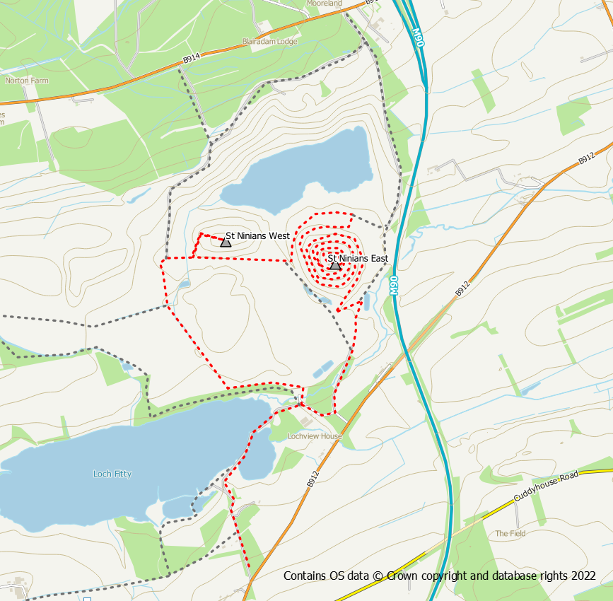
St Ninian’s Circular Walk
The route suggested below is a circular walk from Kingseat taking in St Ninian’s East and St Ninian’s West along with the Loch Fitty causeway. This route is shown in red on the above map.
Distance: 10.3 km / 6.4 miles (can be shortened)
Ascent: 150 m / 490 feet
Terrain: Mostly tracks plus some path around Loch Fitty
Start / finish: Kingseat
Use the route of the Fife Pilgrim Way out of the village and down to Loch Fitty. As you cross the causeway at the eastern end of the loch you will see the form of St Ninian’s ahead of you. Once into St Ninian’s you have the choice of keeping to the main track with forms the Fife Pilgrim Way or using grassy paths further to the west. Whichever route you choose, St Ninian’s East is clearly visible ahead. One of the spiral paths starts from the south side, the other from the north. They both lead to the 3 peak summit with its unique art forms and machinery avenue.
After descending the eastern hill use the track across to the western hill for an ascent of that too. Unlike its neighbour, this hill does not have any sculptures and its path (which goes up the west side) is less long-winded.
After this hill, further tracks head west and then south alongside trees back towards Loch Fitty. Return over the causeway and back to Kingseat. Before doing so though, it is worth spending a bit of time exploring the shores of Loch Fitty itself.
