Hills: Cairnie Hill (228.9m), Dunbog Hill (216m), Cunnoquhie West Hill (199m), Balmeadow Hill (196m), Cunnoquhie East Hill (151m)
These hills make up the high ground between Collessie Den to the west and the A92 to the east. The highest point at 228.9m is Cairnie Hill one of Fife’s marilyns. Cairnie Hill can easily be ascended on its own for a short day but the more energetic walker can combine it with nearby Dunbog Hill and even the three hills further east for a longer day. This area is all working countryside both farming and pheasant rearing/shooting, so ensure your actions are in accordance with the Scottish Outdoor Access Code and keep dogs on a lead where signs request this or there is livestock nearby. When crossing arable fields always stick to the edges / margins and remember to climb gates at their hinged end (causes less damage).
Suitable starting points are: Collessie (parking at the village hall), Monimail, Letham, Dunbog (parking at the village hall or layby on A913) or from the B937.
Route Map
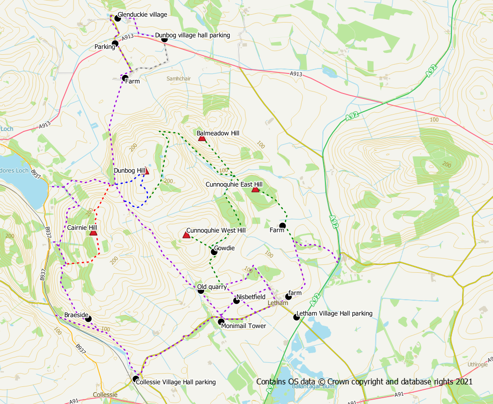
Core paths shown in purple. Route on to Cairnie Hill shown in red. Route on to Dunbog Hill shown in blue. Other hills shown in green.
Cairnie Hill (228.9m)
The summit of the hill can be reached via a track which crosses the hill from south to north (shown in red on the route map). Access to the track can be had directly from the B937 or by a walk-in from either Dunbog or Collessie. The track makes its way up the western side of the hill through fields and trees before turning left to ascend a bracken covered hillside. After passing a small hillock a trodden path leads to the summit area in the trees to the left of the track.
The track continues northwards beyond the summit before coming to an abrupt end. A descent down the north east side of the hill is possible by hopping over the low fence into the rough field on your right. Descend to a gate at NO 280 158 after which it is a steep but straightforward walk down grassy slopes to reach the corner of the field. From here the core path network is regained for a walk back to either Dunbog or Monimail. To return to the west side of the hill, use the tracks to circle around its northern slopes. Alternatively, this is a good point for an ascent of nearby Dunbog Hill.
From the West
The shortest and most direct route up Cairnie Hill is from the B937 at grid reference NO 272 153. From here there is direct access to the track up the western side.
From Collesie
From the south the core path (shown in purple on the route map) through Collessie Den can be used to reach the track on the west side of the hill. A sign beside the Den Burn indicates the start of the path to Lindores via Collessie Den. Parts of this path can be a bit overgrown in the later summer months. Keep right following the sign for Woodmill Mains when the path splits, and then go left through a gate following waymarker arrows. The next section of the path is somewhat overgrown but there are decent views as it gains height. After a short descent the path turns right and meets with the track going up the west side of the hill.
From Dunbog
The hill can be approached from Dunbog to the north using the core path (shown in purple on the route map) to Monimail / Collessie. Arrows help direct the walker around the farm / buildings at Dunbog and on to the path. When the path splits, keep right towards Lindores Loch / Collessie. When the track starts to head downhill to meet the public road at Lindores Loch, go left on a waymarked trodden path into the woods. Once through the woods, keep to the right of the hedge / burn before following the feint path across the grassy fields in a roughly south direction. The path becomes an obvious grass track and meets with the track that goes up the west side of the hill.
Dunbog Hill (216m)
The second highest point in the area, Dunbog Hill is easiest ascended by its western side, shown in blue on the route map. From the track junction at NO 282 162 on the Dunbog to Monimail path there is a straightforward ascent up grassy slopes to the summit trig point. Either descend by your outward route or for a bit of variety continue east to reach a fence which can then be followed downhill to meet with a track. Go right on the track if heading back to Cairnie Hill or the core paths.
Cunnoquhie West (199m)
Easily approached from Letham or Monimail via farm tracks to the ruin at Gowdie. From here a grass field track takes you up to the summit area with just a few gates to climb
Balmeadow Hill (196m)
From Letham or Monimail, farm tracks can be used to reach Gowdie after which there is a field edge track/path into Cunnoquhie Hill West Woods. A track provides easy access through the woods to reach a ford at NO 300 163. From here it is a straightforward walk on grass track/path through the gorse to the summit
Cunnoquhie East (151m)
From Letham there are paths/tracks to the far side of Cantyhall. A grassy field edge can be used to reach a gate (a bit awkward to open) at the southern end of Cunnoquhie East Hill Woods. A track through the woods passes the summit. If continuing to Balmeadow or Counnoquie West keep on the track descending to the north west to exit the woods. A short grass field crossing brings you to the ford at NO 300 163.
Suggested circular route from Collessie
Distance: 10km / 6.5 miles
Ascent: 300 m /985 feet
Terrain: paths / tracks which can be overgrown, grassy fields, quiet road
Use the core path through Collessie Den keeping right on the signed route for Woodmill Mains. At Braeside, turn left through a gate (without a fence) following the arrow markers. Long grass makes for harder work on the next section but once past Woodmill Plantation the going becomes easier. The path descends and turns right to meet with the track for Cairnie Hill. Follow the track up the hill (leaving the core path) bearing left up bracken clad slopes to reach the summit area. A detour, left, off the track is required to reach the actual summit. Once back on the track continue northwards until the track comes to an end. At this point hop over the fence to your right and descend alongside the fence until you reach a gate. Cross the gate into the next field and head down steep grassy slopes in a north east direction to rejoin the core paths (climbing the gate). Go right to reach a T junction.
At this point, turning right on to the track will take you back to Monimail without including Dunbog Hill. To include Dunbog Hill however, keep straight on, crossing over the track, into the field opposite. Depending upon the use of the field at the time you do the walk it may be prudent to keep to the edge of the field over to your right, rather than taking the direct route. If you do take the direct route, keep to the right hand side of the next fence line. From the corner of the field there is easy access into the next field from where you follow a fence on your left (not marked on the OS map) almost to the summit of the hill. Leave the fence, to reach the actual summit with its trig point.
Head downhill from the trig point in a roughly easterly direction aiming for a field corner where you bear right through a gate into yet another field. Follow the field edge to rejoin the track network at a pond. Turn right on to the track, passing trees and fenced off fields. The track will continue downhill to meet the Monimail track that you crossed earlier. Go left when you reach the obvious Monimail track and follow it roughly south to reach a Y junction. Keep left at this point passing an old quarry area before reaching the village of Monimail. From here it is a 1.5km walk back along the road to Collessie. However, before doing so it is well worth having a look around Monimail Tower.
