Hills: Myrcairnie Hill (173m), Craigfoodie Hill (169m), Kedlock Hill (163m), Murdochcairnie Hill (157m), Foodie Hill (156m), Darklaw Hill (150m), Kilmaron Hill (147m), Moonzie Hill (138m), Colluthie Hill (130m), North Hill (123m).
These hills are a compact group of wee hills making up the high ground to the north of Cupar. Most of these hills are rather similar in character standing out as wooded high points amongst the lower agricultural land.
Access is generally not difficult but does involve crossing working farmland and the guidance of the Scottish Outdoor Access Code should be followed. Keep to field edges, don’t walk over crops, avoid disturbing livestock, if a gate has to be climbed do so at the hinged end (less likely to cause damage). Parking is not particularly easy for these hills and if parking on verges bear in mind that wide farm vehicles need to use the narrow roads (and emergency vehicles). Cars should not be parked across field entrances. That might should like an awful lot of “do nots” but we are very fortunate that we do have a right of access to these types of areas (other countries do not).
Map
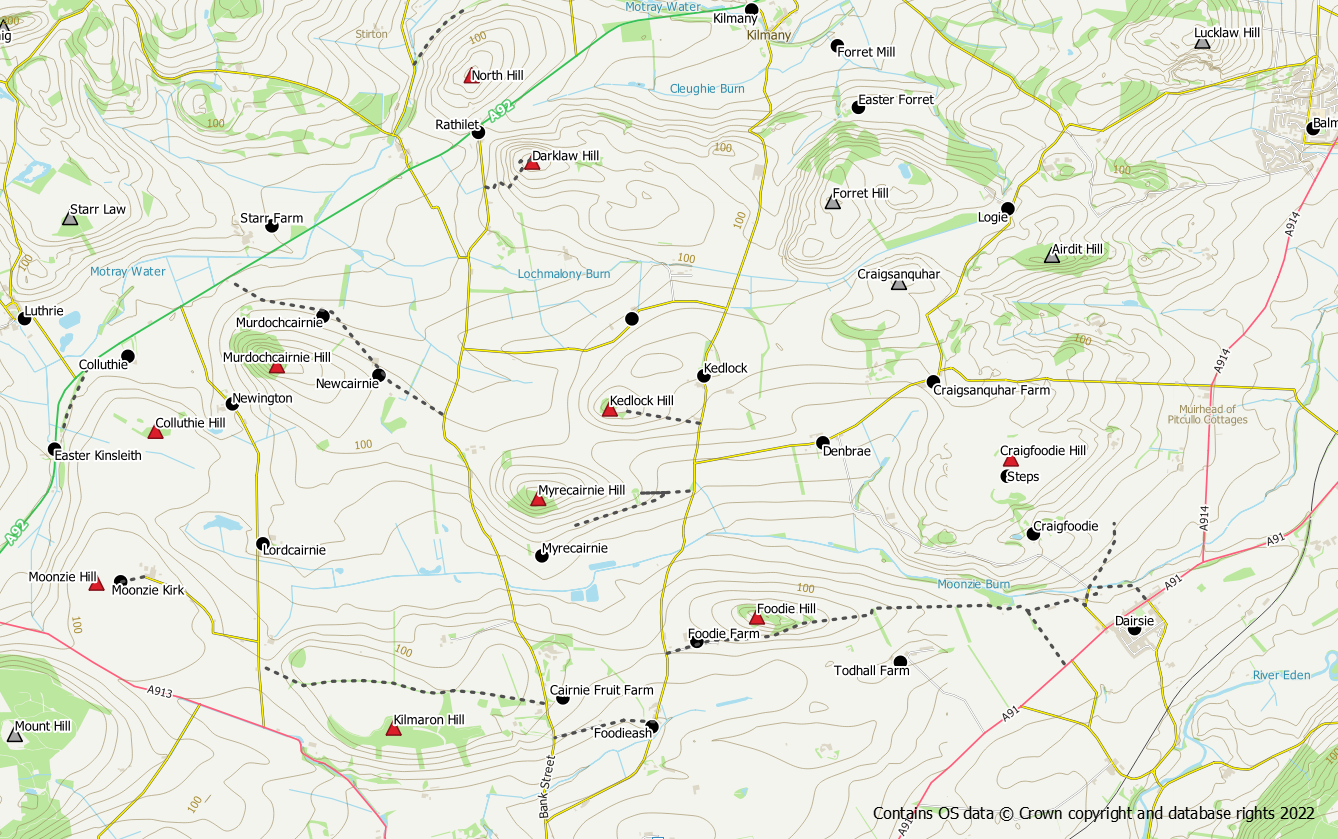
Myrecairnie Hill 173m
This is the highest hill in the group. It’s not difficult but an ascent will involve barb wire and rough walking through the trees. There is a track from the eastern side which can be used up to the first stand of trees. Beyond here continue along the field edge to reach the woods were two barb wire fences need to be crossed. Livestock may be in the field. An alternative is to use the track to reach the south east side of the hill and follow the field edge up from there. Again it will be necessary to cross barb wire to gain access to the woods. The summit trig point can be found amongst the trees.
Craigfoodie Hill 169m
Access is straightforward from Dairsie using core paths to reach a point at NO 41230 18028. From here it is possible to walk around field edges up to the summit of Craiglug (also 169m). From here access to Craigfoodie is possible via stone steps over a wall at NO 40447 18388 or a gate at NO 40544 18385.
Kedlock Hill 163m
Ascent from the east is straightforward via a track between the fields. Once up in the woods there is a path that circles around the outer edge of the woods. The trees are planted thinly enough to provide easy access to the summit. Ascent from the north should also be possible but does include some barb wire.
Murdochcairnie Hill 157m
A straightforward ascent can be had from Newcairnie either directly opposite the farm or from further along the road through a line of pine trees. A couple of barb wire fences are reasonably easy to cross and access to the summit is straightforward once in the woods.
Foodie Hill 156m
A lovely wooded hill that is easy to access from the track heading east from Foodie Farm. Keep left at the house passing a doocot. Access to the hill is possible through a gate and across a field (may contain livestock) or by staying on the track until the woods are reached. Either way an old fence needs to be crossed to access the woods but it is easily negotiated.
Darklaw Hill 150m
Quite a distinctive hill from the main road due to the presence of a communications mast on its summit and its gorse clad slopes. Ascent is easy via a service track for the mast starting from the road near Rathillet at NO 36564 20518.
Kilmaron Hill 147m
Another easy ascent. Use the core path between Cairnie and Moonzie to reach the northern side of the hill. There is a gate into the woods (although the fence is also easily crossed) and a track / paths going up the hill. The path doesn’t go all the way to the summit but the trees do not present any difficulty.
Moonzie Hill 138m
This hill is a lovely spot beside Moonzie Kirk, with an open outlook all around. The hill summit itself lies in an arable field and may not be accessible all year round (please do not walk across crops to reach it). Even if you cannot reach the actual summit a visit here is still worthwhile and the summit will still be there later. There is a rough track up from Moonzie Farm and there would appear to be no objections to taking a car up it (don’t block the track though as access is required for farming purposes). The road along to Moonzie Farm and the track up to the church are core paths and are a pleasant walk.
Colluthie Hill 130m
A lovely tree topped hillock. Can be accessed from the west via field edges. The old railway line provides access to the edge of the fields and there are openable gates higher up. The track up to the wind turbine to the east provides another point of access.
North Hill 123m
Although to the north-west of the main A92 road at Rathillet this hill is topographically a “child hill” of Mount Hill and fits naturally into the Cupar Hills group. It can be approached from the north via grassy slopes. Use the old railway line from the bridge on the minor road to the west, to access the hillside.
Hill of Carslogie 87m
This is another hill where the summit lies in an arable field albeit fairly close to the field edge. Avoid walking over crops to reach the summit. Apart from the crops access is easy enough along the field edges from the minor road to the west.
