Hills: Mount Hill (222m), Hill of Carslogie (87m).
Mount Hill is a distinctive hill in the north of Fife instantly recognisable due to the Hopetoun Monument on its summit. Although not one of the highest hills in Fife it does have the accolade of being one of Fife’s seven marilyns.
It can easily be approached by a number of routes from the minor road to its south and east. There is limited parking available on this road though (if parking on the verge bear in mind that it is used by wide farm vehicles) but there are options to walk in from Letham or Over Rankeilour.
Route Map
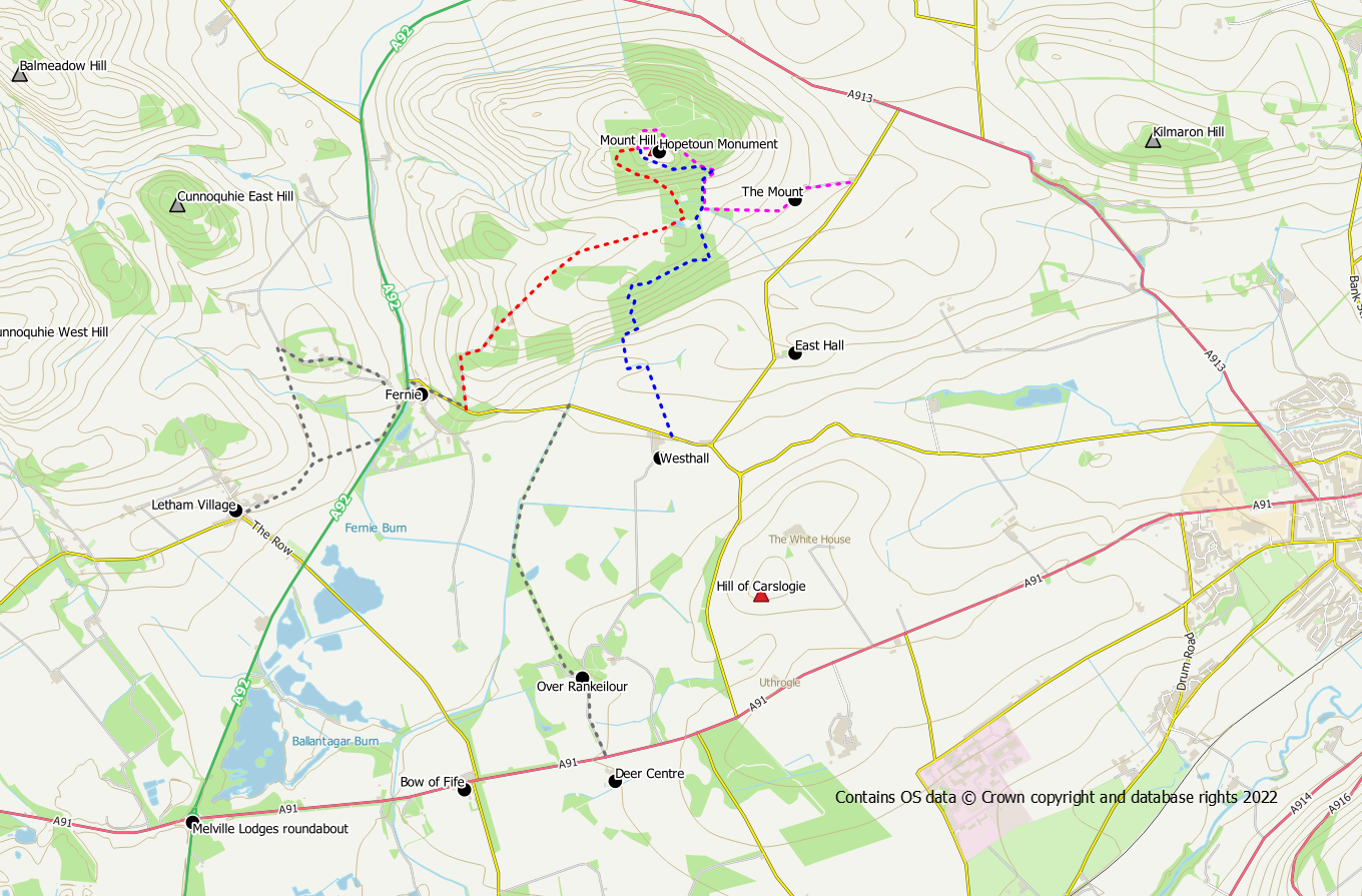
From The Mount
This signposted route (shown in magenta on the route map) is the shortest and quickest way up the hill. However, there is only space for one car to park at the start point.
Follow the Scotways sign post on a track starting at NO 33892 15921, initially over fields and then into woodlands. All junctions are conveniently signposted so just keep on progressing up the hill following the signs. On reaching the summit area you need to pass through a deer gate on the west side to reach the actual summit with its monument and trig point.
From Westhall
A track (shown in blue on the route map) starts from the road at NO 33181 14846 near Westhall Farm, heading up the hill across fields and through woodland used for pheasant rearing. Keep heading upwards, joining the sign posted route at NO 33364 16144. From here you can follow the signed route around the east and north of the hill to reach the gate on its western side, or follow other tracks around the south and west. Either way you need to reach the gate on the west side for access to the summit.
From Fernie
A farm track (shown in red on the route map) leaves the road at NO 32016 15011 heading up the hill through fields and passing a large barn. If the gate at the bottom of the track is locked this route may not be feasible. Livestock may be present so keep dogs on a lead. When the track comes to an end, cross the field diagonally, passing through a gate (fence not shown on the OS map) to reach the far side. A wooden gate with barb wire needs to be climbed to access a track in the woods. The track passes a pond and reaches a junction. Keeping right at the junction will meet with the track from Westhall and the signed route from The Mount. Going left also heads up the hill to reach the gate to the west of the summit. Whichever route you choose you need to aim for the gate.
Walk-in from Letham
There is easy parking in Letham at the village hall. A core path to Fernie starts at Letham Farm. The actual route of the core path follows field edges to meet with a track/road to the north of Cunnoquhie. Go right on this track to follow it out to the main road. Walk behind the cottage and across the grass verge on a trodden path. Take extreme care when crossing the main road to reach Fernie on the opposite side. An alternative to the core path entails going through a pedestrian gate to the right and following a field edge path to reach a small bridge. A woodland path then takes you to the Cunnoquhie track close to the main road.
Walk-in from Over Rankeilour
This route starts directly opposite the Scottish Deer Centre. The initial stages of the walk are on the metalled access road leading through Over Rankeilour. On reaching the buildings, keep left before following the track round to the right. This track will take you to the minor road south of Mount Hill from where you can go left for the Fernie route or right for the Westhall or The Mount routes. It may be possible to park at the Deer Centre if you ask permission.
Suggested Circular Route via The Mount returning via Westhall
This short circular walk combines the magenta and blue routes on the route map.
Distance: 6 km / 3.5 miles
Ascent: 200 m / 650 feet
Terrain: Gravel and dirt tracks and some tarmac road walking on quiet roads
Follow the sign posted route up the hill to reach the summit via the deer gate on its western side.
Return back to the deer gate and turn left around the south side of the hill to rejoin the outward route at a junction. Keep right at two junctions so that you are on your outward route. However, at the next junction (a T junction), turn to the right on a forest track leaving your outward route. Keep left downhill at the next junction. The track now descends the hill through woodland to reach yet another track junction. Our route goes right here but if you went left it would take you back to the road and provides a short cut back to the start. There is now a wee bit of ascent before the track turns left and winds its way steeply down the hillside to exit the woods. Continue on the track which will bring you out to the road close to Westhall Farm. Go left for a road walk back to the start.
Hill of Carslogie (87m)
This is a wee hill lies south of its parent Mount Hill. Its summit is just a short stroll from the minor road to its west. It is arable land so stick to the field edges and do not walk over crops.
