Pitmedden Forest
Pitmedden Forest is a working Forestry and Land Scotland plantation, that lies on the border between Fife, and Perth & Kinross. Very popular with mountain bikers it also offers opportunities for the walker. Although not waymarked, there are many miles of forest road and informal trails, particularly in the southern section. The suggested routes below can be followed “as is” or you can use them as the basis for your own explorations. Note that the mountain bike trails can become very muddy at times Take care to be aware of any approaching mountain bikers and step aside for them when using these trails. Please note that there are no waymarked trails in the forest though you may encounter core path markers from time to time.
The forest itself is an interesting mix of spruce, pine and larch which provide contrasting areas for walking in. As you walk around open areas of the forest listen out for the call of buzzards hunting in the fields. If you are lucky you may even spot a red squirrel.
Route Map
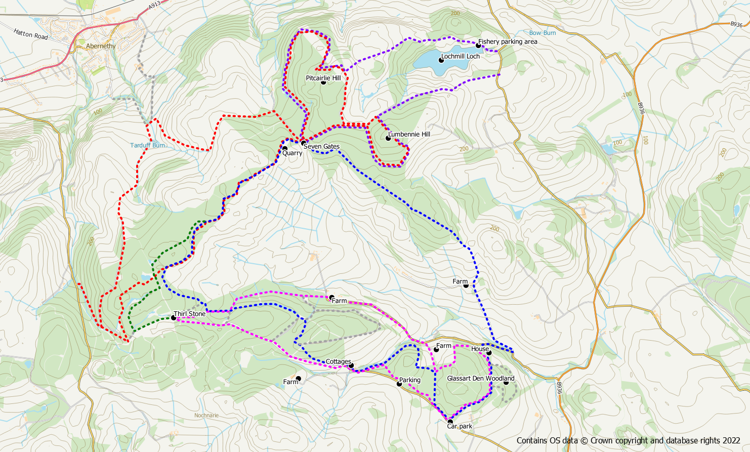
Route 1 – Short walk from the Clink (magenta)
- Distance: 5 miles / 8 km
- Ascent: 730 feet / 220m
- Terrain: Unsurfaced paths and forest tracks, some quiet road
- Start / finish: The Clink car park near Auchtermuchty, grid reference NO 222 128
From the car park either use the main path (through the gate), or the pleasant alternative to the right of the main path. At the gate into Glassart Den Community Woodland there is the option to do a loop around the edge of the woodland returning to the main path at a pedestrian gate further down the hill.
Keep left at a Y junction with a marker post, away from the house to skirt the edge of the woods. At the next junction the track to the right heads out of the woods to meet a farm road. Go left downhill on this road and then left on to the public road at the bottom of the hill.
West Pitmenzies is reached after about 1km of quiet road walking. After the farm there is a gate on the left leading back into the forest. Follow this track into the forest keeping straight on through another gate. Keep to the track through thick spruce trees as it becomes a bit muddy and reaches a cross road. Go right at the crossroad, gaining height on the main track. At the top of the hill is a bench seat and the Thirl Stone. Go left at this point on a forest road with a marker, for a straightforward walk to Newhill at the exit of the forest.
The road from Newhill goes back to the car park but the hard surface can be avoided by re-entering the forest at a barrier gate. Keep right, to follow paths through the forest back to the car park
Route 2 – Pitmedden Circuit (blue)
- Distance: 6.5 miles / 10.3 km
- Ascent: 985 feet / 300m
- Terrain: Unsurfaced paths, forest tracks, mountain bike trails
- Start / finish: The Clink car park near Auchtermuchty, grid reference NO 222 128
Two options for this walk are provided. The first makes use of mountain bike trails which can be somewhat muddy and may not be to everyone’s liking. The second option uses forest roads.
From the car park go through the gate onto a good path passing through pine, then beech and then larch trees. Keep straight on at the junctions until you reach the area of a house. Follow the purple arrow markers firstly right and then left out to the road. Turn right downhill for 300m to reach the access road for Pitmedden Farm to the left. Walk uphill to the farm, turning right before the main farm buildings to pass through a gate. A track now takes the walker uphill to the forest edge at a pedestrian gate.
Enter the forest still going uphill but at an easier gradient. Keep straight on until the area of “Seven Gates” is reached with a barrier gate across the track. Go left through the gate passing a quarry area. Either keep on this forest road (option b) or explore the trails below (option a).
Option a – mountain bike trails
For enjoyable (but muddy) off road walking pick up a mountain bike trail on the right hand side opposite an open section of forest. The trail heads into the trees, turns left and roughly parallels the road. Ribbons tied to the trees assist with route finding and the track is generally still within sight through the trees. When the trail goes steeply downhill keep left and then left at a T junction to return to the forest road.
Cross over the road and pick up another trail on the opposite side. Keep left to reach the edge of the forest and turn right. This trail is more open and offers views, as well as being drier due to benefitting from sunlight. Follow the fence line along the forest edge until the path starts to turn left at a corner. Keep straight on going around the corner and turn left at the next junction into an area of spruce, to the right of a low fence.
Head downhill and go left on to a forest track at the bottom of the hill. After 250m turn right at a junction where the track become more of a path than a track. On reaching the next forest road turn left and then immediately right through a gate. Just after the left hand corner is an obvious trail/path to the right. A farm should now be visible through the trees. Keep left at a junction and follow the path out to the public road at Newhill. Purple arrows direct the walker around the buildings.
Option b – forest roads (green)
Keep to the forest track which will head away from the forest edge and start to go downhill to reach a barrier gate at a wide junction. Go left at the junction and after 400m reach the thirl stone and a bench seat. Continue straight on following a purple arrow marker. It is now a straightforward walk along this road to Newhill. From time to time there are purple arrow markers along the route. A further bench seat is located on the left under an old beech tree part way along. The road exits the forest at Newhill.
Both Options
The road from Newhill will head back to the car park. However, 1km of road walking can be avoided by bearing left through a barrier gate. From here there is a network of paths that can be followed. Following the main path beside a burn around the back of a small hillock is a good option. When the path follows a wall there are clear views over to Pitmedden Farm on the hillside. After the wall has turned left, go right on a path to leave wall and head back to the car park.
Route 3 – Pitcairlie and Lumbennie From Abernethy Glen (red)
- Distance: 8 miles / 13km
- Ascent: 1250 feet / 380m
- Terrain: Unsurfaced paths, forest tracks, fire break, mountain bike trails
- Start / finish area: Abernethy Glen entrance to forest at grid reference NO 188 141 (limited parking at the entrance and alongside the forest road). The route could also be started from Abernethy.
Head up the main forest track keeping straight on at the first junction to reach a wide corner. Go left here on a mountain bike trail between spruce and pine trees. After passing a small pond cross over a burn. At a junction keep right on the main path away from the fence. At the top of the hill the trail turns right and left to meet the forest road. (An alternative means of reaching this point is to simply stick to the main track turning left through a barrier gate at the second junction).
Cross over the road and pick up another trail on the opposite side. Pass two ponds and turn right at the second pond to reach the forest edge. Go left onto a path which runs along the edge of the forest with open views. The path will head back into the forest to rejoin the forest track but before it does so pick up another trail to the right up a short steep slope. This path too, will return to the forest road. (Again it is possible to stick to the forest road rather than using the trails). Turn right on to the road or alternatively, use mountain bike trails (rather muddy) on the opposite side of the road, roughly parallel to the road.
After passing a quarry area go straight on at a junction through a barrier gate and up the hill. To include Lumbennie Hill, the highest point of the forest at 284m and the 12th highest hill in Fife, go right at the next junction. To miss out Lumbennie turn left to Pitcairlie Hill.
Turn right again onto a grassy track that circles Lumbennie Hill to reach a firebreak and powerlines on its south eastern side. A rough path goes up the firebreak to reach the summit trig point. Continue over the summit through the firebreak to emerge back onto a forest track on the north west of the hill and turn left. Keep straight on at the first junction follow the purple arrow and then go right at the next junction to Pitcairlie Hill
The track circles the hill with excellent views northwards over the Tay. The actual summit lies just off the track and will require a short detour. Keep following the track around the hill to return to the barrier gate.
Go right at the gate through some beech trees to reach a field. Follow the yellow arrow markers left into trees and right at a T junction. Leave the forest through a pedestrian gate. The path goes left following the field edge (keep dogs on a short lead if there are sheep around). Head downhill on the track towards Abernethy keeping left at a signpost to cross the river. Follow the signpost left, on the other side heading back up the hill towards a house and wind turbines. The path goes around the left of the house through a gate to reach an entrance back into the forest. Keep straight on at a junction and follow the track through the forest turning sharp right to return to the forest entrance.
Route 4 – Lumbennie HIll and Pitcairlie with Lochmill Loch (purple)
- Distance: 7 km / 4.5 miles
- Ascent: 200 m / 650 feet
- Terrain: Unsurfaced paths, forest tracks, fire break,
- Start / finish area: Entrance to Pitmedden Forest at NO 22741 16081 (near Newburgh)
From the entrance to the forest at NO 22741 16081 head westwards along the signed cycle route. The initial section offers a few tantalising glimpses of Lochmill Loch before entering the more denser forest. After 1.2km the powerlines cross the track and there is a fire break beneath them. To reach the 284m summit of Lumbennie Hill leave the track going left on a trodden path up through the fire break. The summit of Lumbennie Hill is marked with an OS triangulation pillar. Descend the other side of the hill still using the trodden path through the firebreak beneath the pylons. On reaching a grassy track on the edge of the forest, turn right and follow it back into the forest. Stick with this track for about 750m as it circles Lumbennie Hill to bring you back to the north-west side of the hill. At the obvious T junction, going right will take you back to the start point on the road. However, turn left and after about 250m a further junction is reached.
At this point you can decide whether or not to include a circuit around Pitcairlie Hill. If omiting this section, turn right here and follow the track for about 550m to reach the point described below where the route branches off down the hill.
If including the Pitcairlie circuit continue straight on for 400m to the next junction at “Seven Gates” (there’s only one barrier gate) and turn right. Follow the track around the northern side of Pitcairlie Hill where there are good views north over the Tay. The track continues around the eastern side of the hill rising to its highest point, a short distance from the actual 282m summit of the hill.
If you are tempted to go to the summit of the hill it is not particularly easy as it lies in dense conifer forest and is awkward to reach.
At NO 21290 16119, about 100m after the pylon lines cross the track for the third time, there is a feint trodden path on the left (east) through the gorse. This path isn’t particularly easy to find, the best landmarks being the edge of the conifer trees to west of the track and a multi-trunk birch tree also on the west (right) side. If you look closely you will spot signs of where the gorse has been cut back. Follow this trodden track through the gorse for a short distance to reach a gate. The gate is locked and needs to climbed, or alternatively squeeze through the fence, to reach the open hillside on the other side.
From here there is a feint trodden path on the grass downhill in a north-easterly direction. Follow the line of the path down the hill, keeping the stand of trees to your right. There are now views ahead to Lochmill Loch. Keep north-east until a farm track and gate are reached. Join the track, passing through the gate, into woodland. This next section through the woods down to the dam is delightful. After passing through a pedestrian gate the fishery car park is reached and a rough road leads out to the public road. From here it is a short walk 250m road walk up the hill to the start point.
