Fife Trig Pillars
The Ordnance Survey triangulation pillar is well known to hill walkers as it often adorns a hill summit or is located very close to the summit. However, the trig pillar is much more wide spread, with the lowest in Scotland being at a height of just 2.6m above sea level. The concrete trig pillars as we know them today were constructed from 1936 through to the 1960’s as part of the Ordnance Survey’s retriangulation of Britain, At the time of their construction all pillars would have had clear views to neighbouring pillars. Sadly modern forestry and land use changes mean this is no longer guaranteed!
The pillars are often referred to as trig points but the term trig point (triangulation point) is actually much wider than the familliar pillar as it also includes buried underground blocks, bolts, and prominent landmarks (and much more) all of which were used by the OS surveyors to produce accurate mapping. Trig pillars can be found and “bagged” by any enthusiastic person with some being easily accessible from the roadside. However, some of the other types of trig point require considerably more dedication and will have you digging holes in the ground looking for them.
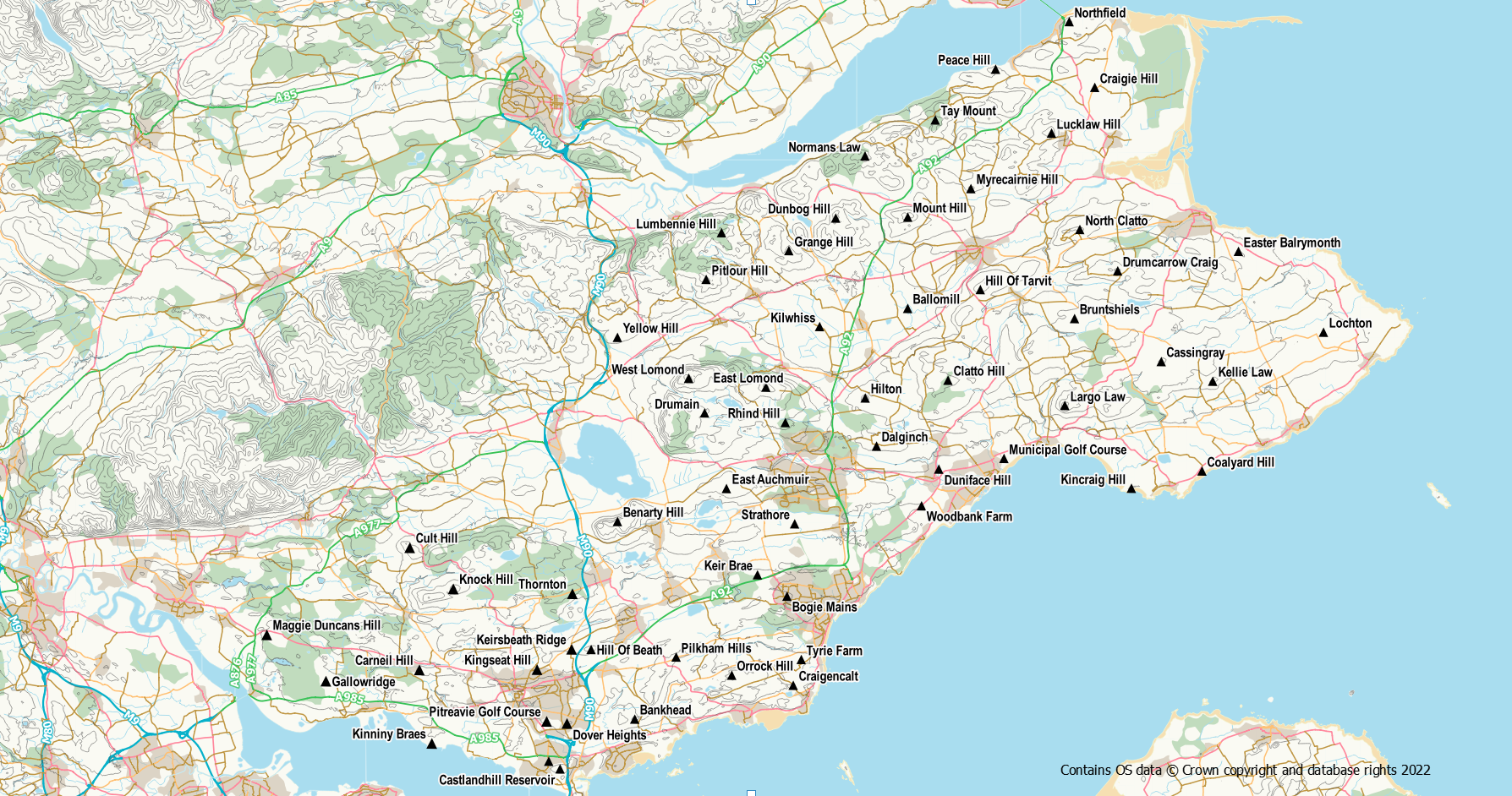
There are 58 intact OS triangulation pillars in Fife (and two that have been destroyed). However, two of the 58 have been toppled and moved, and are currently abandoned in fields.
Each trig pillar (though there are some exceptions) is uniquely identified by means of its flush bracket number, a metal plate on the side of the pillar. This is usually a 4-digit number beginning with S. Whilst the pillar was used to measure “the shape of the land”, the flush bracket was used to determine its height (a process known as leveling). As well as trigs, flush brackets can be found on walls and buildings throughout the country and are known as benchmarks. Other types of benchmarks also exist but that is a whole different topic!
In Fife there are three fundamental benchmarks which are highly accurate benchmarks. These take the form of what looks like a mini-trig. They are small pillars about 12 inches high with an underground chamber. Being small, they get hidden in long grass and vegetation so can be more of a challenge to find than the usual trig pillar.
In today’s digital era, the majority of these concrete pillars, along with the benchmarks, are now redundant having been superseded by satellite and aerial based surveying. However, a number of pillars were repurposed as “passive stations” and until recently were used in the OS’s modern GPS network. There are three such stations in Fife and they can be identified by a wee plaque telling you it is a criminal offence to damage it! These pillars being:
In addition the fundamental benchmarks mentioned above are also part of this passive station network.
In the era before satellite based surveying, the triangulation stations were used to form a network of triangles the length and breadth of the country. The pillars were used as an accurate and stable base on which could be placed the measuring equipment. By measuring the angles between points and knowing the distance of one side of the triangle, it was possible to calculate (using trigonometry) the other distances and thus produce accurate mapping. Triangulation itself was originally used in Britain in the 18th and 19th centuries (the Principal Triangulation) but the original network was somewhat inconsistent and haphazard. In 1936 the retriangulation was started and the trig pillar as we know it today was born. A diagram of the composition of a trig pillar is available on the OS blog.
| Name | FB number | Grid Reference | Location | |
| Central Fife trigs | ||||
| West Lomond | S1615 | NO 19730 06639 | Hill | |
| Keir Brae | S3138 | NT 23931 94624 | Forest/woods | |
| Benarty Hill | S3140 | NT 15379 97881 | Hill | |
| East Auchmuir | S3142 | NT 22035 99898 | Grazing field | |
| Strathore | S3144 | NT 26203 97740 | Field | |
| Drumain | S3149 | NO 20703 04521 | Forest/woods | |
| Duniface Hill | S3153 | NO 35009 01085 | Forest/woods | |
| Dalginch | S3156 | NO 31204 02492 | Grazing field | |
| Hilton | S3158 | NO 30514 05434 | Field | |
| Rhind Hill | S3160 | NO 25632 03930 | Grazing field | |
| Clatto Hill | S3162 | NO 35571 06518 | Forest/woods | |
| East Lomond | S3163 | NO 24447 06094 | Hill | |
| Woodbank Farm | S4216 | NT 33953 98841 | Field | |
| East Fife Trigs | ||||
| Kellie Law | S1611 | NO 51744 06458 | Hill | |
| Cassingray | S3150 | NO 48600 07659 | Field | |
| Coalyard Hill | S3151 | NO 51088 00971 | Field | |
| Largo Law | S3152 | NO 42706 04979 | Hill | |
| Kincraig Hill | S3161 | NT 46775 99914 | Rough ground | |
| Municipal Golf Course | S4215 | NO 38991 01739 | Golf course | |
| Bruntshiels | S4769 | NO 43302 10288 | Grazing field | |
| Easter Balrymonth | S4792 | NO 53314 14397 | Field | |
| Drumcarrow Craig | S4809 | NO 45938 13205 | Hill | |
| North Clatto | S4810 | NO 43623 15735 | Grazing field | |
| Lochton | S4811 | NO 58510 09455 | Field | |
| North Fife Trigs | ||||
| Kilwhiss | S4768 | NO 27728 09801 | Destroyed | |
| Grange Hill | S4770 | NO 25848 14442 | Forest/woods | |
| Lumbennie Hill | S4771 | NO 21735 15540 | Forest/woods | |
| Dunbog Hill | S4773 | NO 28710 16433 | Grazing field | |
| Mount Hill | S4774 | NO 33112 16490 | Hill | |
| Ballomill | S4775 | NO 33108 10908 | Rough ground | |
| Myrecairnie Hill | S4788 | NO 36968 18234 | Forest/woods | |
| Hill Of Tarvit | S4789 | NO 37546 12061 | Hill | |
| Tay Mount | S4790 | NO 34793 22431 | Grazing field | |
| Lucklaw Hill | S4791 | NO 41895 21630 | Hill | |
| Normans Law | S4793 | NO 30501 20229 | Hill | |
| Craigie Hill | S4794 | NO 44535 24424 | Golf course | |
| Northfield | S4795 | NO 42977 28442 | Field | |
| Peace Hill | S4823 | NO 38477 25535 | Field | |
| Yellow Hill | S5918 | NO 15376 09139 | Field | |
| Pitlour Hill | S5920 | NO 20795 12683 | Hill | |
| South Fife Trigs | ||||
| Craigencalt | S3145 | NT 26115 87867 | Field | |
| Orrock Hill | S3146 | NT 22361 88486 | Rough ground | |
| Pilkham Hills | S3164 | NT 18963 89597 | Grazing field | |
| Bankhead | S3168 | NT 16434 85800 | Field | |
| Hill Of Beath | S3169 | NT 13768 90057 | Hill | |
| Castlandhill Reservoir | S3239 | NT 11870 82759 | Compound | |
| Bogie Mains | S4218 | NT 25735 93312 | Residential | |
| Tyrie Farm | S4219 | NT 26607 89447 | Field | |
| Fleet Recreation Ground | S4411 | NT 11181 83224 | Destroyed | |
| West Fife Trigs | ||||
| Thornton | S3166 | NT 12626 93464 | Forest/woods | |
| Kingseat Hill | S3167 | NT 10468 88826 | Residential | |
| Gallowridge | S3201 | NS 97567 88120 | Rough ground | |
| Kinniny Braes | S3202 | NT 04037 84312 | Inaccessible (MOD) | |
| Maggie Duncans Hill | S3205 | NS 93956 90951 | Grazing field | |
| Knock Hill | S3207 | NT 05349 93761 | Hill | |
| Cult Hill | S3208 | NT 02691 96276 | Hill | |
| Carneil Hill | S3237 | NT 03277 88806 | Grazing field | |
| Dover Heights | S4412 | NT 12293 85531 | Rough ground | |
| Pitreavie Golf Course | S4414 | NT 11051 85661 | Golf course | |
| Keirsbeath Ridge | S4416 | NT 12579 90068 | Private garden | |
Fundamental Benchmarks
| Name | Grid Reference | Benchmark Database Link |
| St Andrews | NO 5344 1489 | https://trigpointing.uk/trig/497 |
| Rosyth | NT 1109 8233 | https://trigpointing.uk/trig/7197 |
| Kinghorn | NT 2725 8842 | https://trigpointing.uk/trig/7138 |
Other Trig Points in Fife that are in tact and have been “found”
| Name | Type | Grid Reference | Link |
| Rosyth FBM Aux | Berntsen | NT 10774 82646 | https://trigpointing.uk/trig/581 |
| Cowdenknowe (Cowdenbeath) | Block | NT 15093 89831 | https://trigpointing.uk/trig/16358 |
| Shieldbank (Saline) | Surface block | NT 00867 94034 | https://trigpointing.uk/trig/71 |
| Kinsleith (Parbroath) | Surface block | NO 33340 18256 | https://trigpointing.uk/trig/44 |
| Bankhead (Kirkcaldy) | Block | NT 23775 92984 | https://trigpointing.uk/trig/16370 |
| Markinch War Memorial | Buried block | NO 29699 02197 | https://trigpointing.uk/trig/16377 |
| Bandon (Glenrothes) | Block | NO 27842 04002 | https://trigpointing.uk/trig/16379 |
| Lindifferon Hill (Cupar) | Block | NO 32875 16681 | https://trigpointing.uk/trig/15596 |
| Goatmilk Hill (Glenrothes) | Bolt | NO 24524 00079 | https://trigpointing.uk/trig/16415 |
| Tents Muir | Block | NO 50005 26732 | https://trigpointing.uk/trig/11924 |
Apart from the MOD trig, the Fife trigs present little in the way of access problems. However, many of them are in working countryside so it is important to bear in the mind the provisions of the Scottish Outdoor Access Code. In particular it is worth noting that access rights do not extend to farm yards, private gardens, quarries, and working areas. Some of the trigs are in arable fields where crops may be present and you should stick to the field edges to avoid walking on crops. If it is not possible to access the trig without walking over the crop (this may be the case for Yellow Hill, Easter Balrymonth and Hilton), come back at another time of the year or view from a distance. Keep dogs under close control at all times but especially so when livestock are around. One trig (Keirsbeath Ridge) is in a private garden but is visible from the road. However, if you wish to get up close to the trig you should ask permission first.
Reaching a trig may involve squeezing through barb wire, negotiating electric fences, overgrown vegetation, inquisitive cattle, and mud! Use gates where possible and leave them as you find them. If you need to climb a gate do so at the hinged end as this reduces the risk of damage. Winter and Spring are better than late Summer and Autumn for the heavily vegetated ones.
Photographs of these trigs can be viewed on the Trig Photo Gallery page.
Why not post a trig log on to the TrigpointingUK website? Record your visit, make a note of the condition you find the pillar in and any damage it has suffered, add a few notes on what route you used to reach it (helpful for people in the future) and optionally include a photograph of it. You can even give it a score out of ten! If you start visiting a large number it will be a helpful record of where you have been.
References / Further Reading:
- History of the Retriangulation of Great Britain 1935 – 1962
- https://www.ordnancesurvey.co.uk/gps/legacy-control-information/triangulation-stations
- https://www.ordnancesurvey.co.uk/benchmarks/
- https://www.bench-marks.org.uk/
- https://trigpointing.uk/
- Ordnance Survey Maps a descriptive manual – J B Harley
