These two woodlands are popular walking spots. As both of the suggested short walks start from the vicinity of Dalgety Bay railway station they can easily be linked together for a longer route. It is also possible to include Letham Hill Woods in a coastal path walk between Inverkeithing and Dalgety Bay. The area of Prestonhill Quarry is fenced off and there is no danger if you stay outside the fences.
Route Map
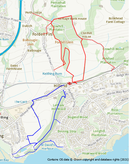
1 – Fordell Woods
The Fordell Estate lies to the north of Dalgety Bay and south of Crossgates. At the heart of the estate is the private residence of Fordell Castle. There are numerous woodland paths and tracks around the estate including alongside the Fordell Burn and the route of the old mineral railway line. The paths can be extremely muddy after heavy rainfall and walking boots are highly recommended for this area. In the Spring there is a good display of snowdrops in the castle grounds.
There are a number of access points into the woods:
- Railway bridge east of Dalgety Bay station (parking in the station car park) grid ref NT 151 841.
- South Lodge entrance on the A921 opposite the industrial estate (parking on street in the industrial estate), grid ref NT 159 844.
- The main entrance at North Lodge on the B981 Crossgates to Inverkeithing Road (small area to park outside the gates), grid ref NT 140 858.
- Fordell Gardens on the B916 Clocklunie Road, grid ref NT 142 853.
- Entrance to woods opposite the Plant Market on the B916 Clocklunie Raod, (rough parking), grid ref NT 145 844.
The route suggested below is a circular walk starting from the station.
Distance: 5.6 km / 3.5 miles
Ascent: 100 m / 320 feet
Terrain: Unsurfaced (often muddy) paths
Start / finish : Dalgety Bay Station
Facilities: free parking at station, regular train and bus service, refreshments nearby
A stone bridge over the railway, to the east of the station, provides easy access into the area. Once across the bridge there is a narrow trodden path heading eastwards along the field edge (keep on the path when there are crops growing in the field). The path turns left on to the embankment of the tree lined mine railway that used to serve the harbour at St David’s.
The railway takes the walker into the woods where the route follows a vehicle track (left) anti-clockwise around the outside of the castle grounds. Alternatively there are rough woodland paths that can be used to avoid walking on the track. On the north west side of the castle the track reaches a crossroad where the main driveway comes in from the right and goes left through the gate to the castle. Soon after the crossroads is a metal gate and a stile on the left, providing access onto a woodland path.
The main path stays up high above the Fordell Burn heading south, but there are alternative rough paths that can be used to walk alongside the river at a lower level. This section can be very muddy at times. On reaching a wide track, the route turns left to do a U turn down to the river and a stone bridge. After the bridge go right, leaving the main track on a woodland path, walking downstream. On exiting the woods there is a path across the field (again stick with the path if there are crops growing) towards a pine tree. From the tree is a track back to the railway bridge at the start of the walk.
2 – Letham Hill Woods
Letham Hill Woods is an old deciduous plantation on the high ground separating Inverkeithing and Dalgety Bay. The circular route described below uses the main core path through the woods. This isn’t the only path in the woods though and other paths are worth exploring. It is also possible to link to the coastal path by using the (muddy) steps from the viewpoint at the south west end of the woods.
Distance: 4.7 km / 2.9 miles
Ascent: 100 m / 330 feet
Terrain: mostly on unsurfaced paths
Start / finish: Dalgety Bay Station
Facilities: free parking at station, regular train and bus service, refreshments nearby
This walk starts at a set of steps on the south side of the A921 west of the station/roundabout. Take extreme care if crossing the busy road from the station. At the top of the steps is a rough trodden path that zig-zags its way up the hill (this is the hard work bit) through the woods. Once up, the path becomes a gentle ascent as it makes its way along the ridgeline towards the 95m summit area. At the summit to the left of the main path is a socket stone. The path continues along the ridgeline through the trees for a further 1km to reach an open area with good views out to the Forth.
From here a path goes west along the back of the quarry (it is not necessary to cross the fence into the quarry area). This path leads to Inverkeithing but there is a short steep link on to a field path to the houses at Spencerfield (new development may change things here). At Spencerfield there is an old signpost and a farm track goes right, to reach Spencerfield Steading from where it is an easy walk out to the Hillend Road. From Hillend Road there is an underpass, under the A921, that connects with a path to the west end of Hillend village. From here the remainder of the walk is through the village (past the pub) back to the station.
