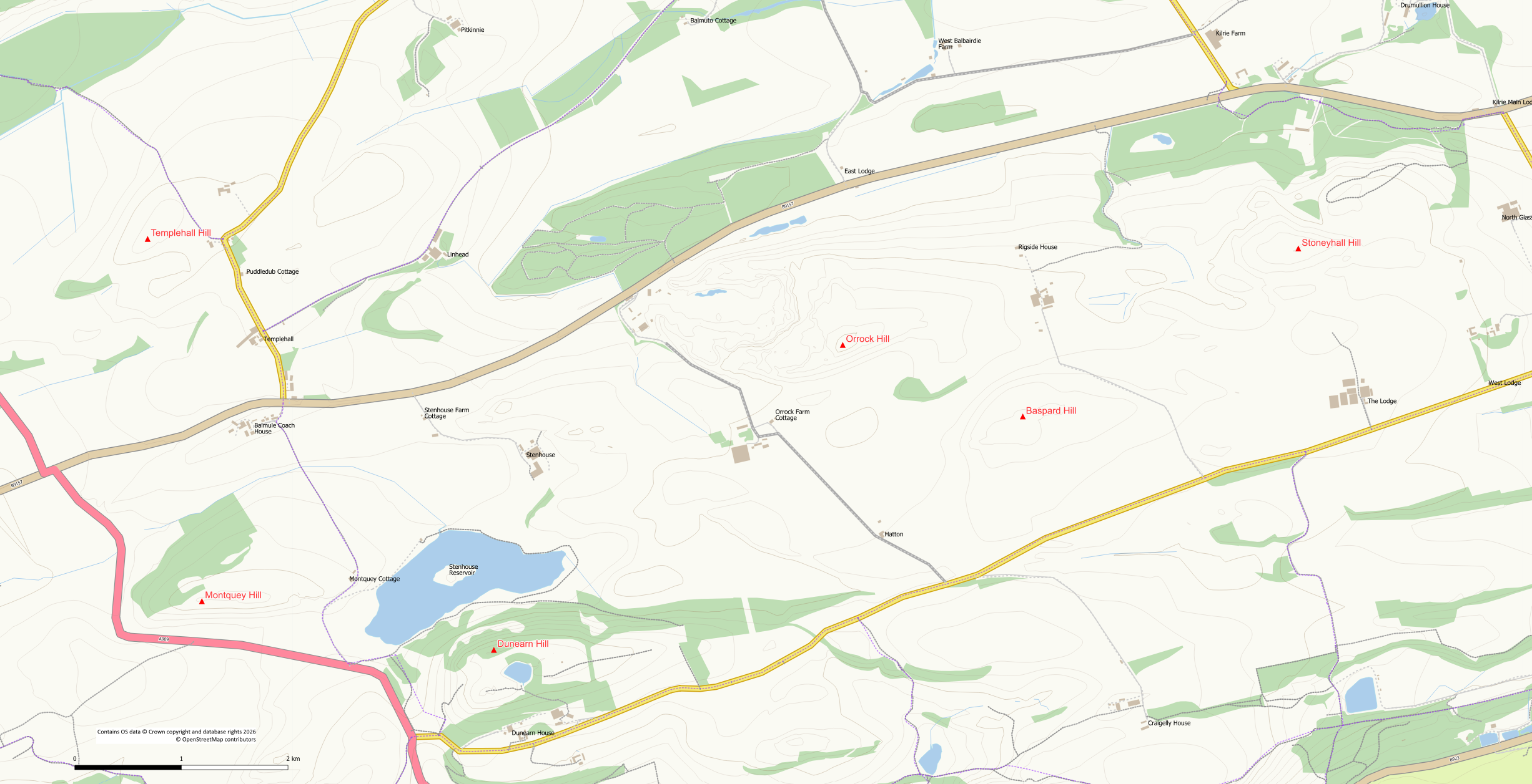
Hills: Dunearn Hill (223.6m), Orrock Hill (205m), Baspard Hill (197m), Stoneyhall Hill (194m), Montquey Hill (164m)
At 223.6m Dunearn Hill is the highest point of the upland between Burntisland and Kinghorn. Not as well known as its nearby lower neighbour, the Burntisland Binn, it is however one of Fife’s finest small hills with a beautiful summit lochan, woodland and superb views over the Forth. The other hills in the vicinity are also good short outings particularly Stoneyhall Hill which, like Dunearn, is a hill-fort site.
Route Map
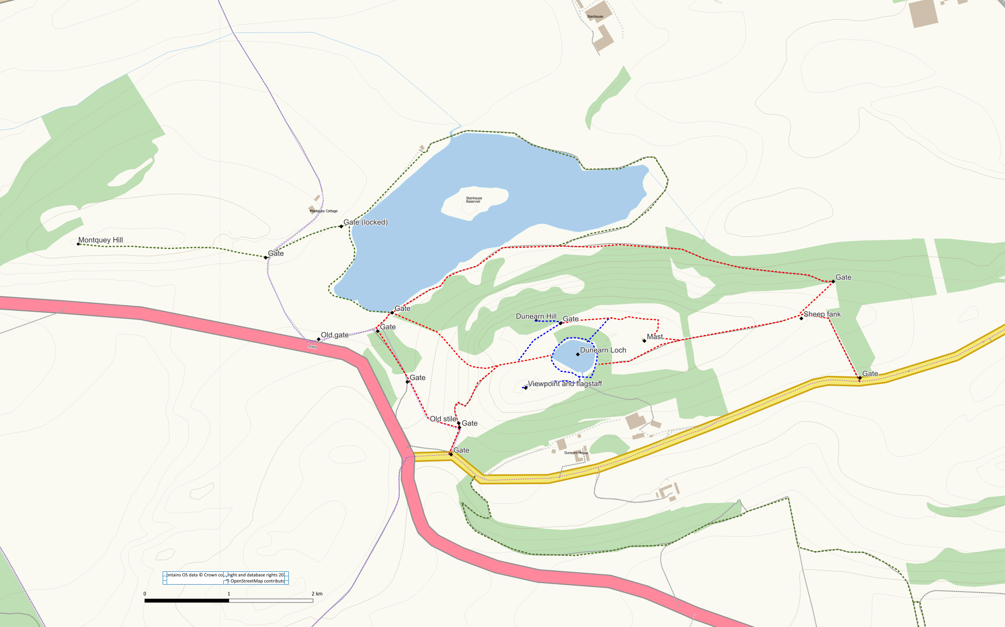
Routes on Dunearn Hill: red – routes to summit area, blue – summit area routes, green – Stenhouse Reservoir, Montquey Hill and the Gorse Path, other core paths shown in purple.
Hills in the area
Dunearn Hill (223.6m)
The Ordnance Survey maps show two summits of 221m height. However, recent analysis has shown that the high point is the northern one at 223.6m. It is however, the lower summit that is more interesting for the casual walker as this is the site of an iron-age hill fort, a restored Victorian flagstaff and offers grand views across the Forth.
This is working countryside so please make sure your actions are in accordance with the Scottish Outdoor Access Code. Close gates behind you and take care not to disturb sheep (give them a wide berth). Please also stay away from the immediate vicinity of the farm and the house (there is no longer any parking available at the farm).
There is very limited parking in the immediate vicinity of Dunearn Hill. However, the area is easily reached on foot by walking up from Burntisland using either the gorse path or over the western shoulder of The Binn. Alternative approaches are possible from the north using the route of The Old North Road from Balmule Farm or from Aberdour to the west using Kemal’s Cut and the signposted Dunearn path.
A selection of routes up the hill are described below. The routes can easily be combined to create your own circular route.
From the East (Standing Stane Road)
A straightforward route is possible from the Standing Stanes Road where a gate at grid ref NT 218 872 provides access to a grassy track leading up to a communications mast. The track heads north up the hill before turning left. Cross this field on the track/path into the next field from where you will see the mast ahead of you. After the mast it is a grassy walk to either the north or the south of the mast to the summit area.
From the Southwest (Standing Stane Road)
A new-ish field gate at grid ref NT 209 871, close to the Dunearn junction on the Standing Stane Road, allows access into a sheep field along the route of a core path. Keeping right following the field edge on a feint trodden path brings takes you through another gate to a large wooden stile. This stile has seen better days so use at your own risk! Cross over the wall and fence using the stile (or find another way if you don’t like the stile). Keep left alongside the wall for a short distance to skirt round the gorse bushes and then follow the trodden path up the hillside to the right. Although a bit steep it is a straightforward ascent up grassy slopes. Folllow the path towards the trees and the summit lochan.
From the Northwest (Stenhouse Reservoir)
This route starts from Stenhouse Reservoir which can be reached by using the core path from the Standing Stane Road. Follow the start of the Southwest route above but do not go through the gate before the stile. Instead cross the field, following a fence down to a gate leading to a small wooded area. An alternative route would be to walk around the western side of the field to reach this gate. A path takes you through the wooded area and through a further gate to the reservoir. Turn right on the path heading for the next gate.
Stenhouse Reservoir can also be accessed from the start of the road to Montquey Cottage from the main A909. You can either use the road and then walk around the eastern end of the reservoir (entails climbing a locked gate) or take the direct route climbing an old rickety gate and following a grassy path.
Go through the gate (NT 208 874) and then turn immediately right onto a trodden path heading up the hillside beside a wall. The hillside is quite steep but the grassy slopes are easy enough. Cross the wall at an obvious broken bit and continue on the path. Before reaching the gorse bushes ahead, bear left up the hillside. You may be able to find a trodden path but if not don’t worry, just head straight up aiming towards the trees at the summit lochan. Soon you will reach the old wall surrounding the lochn.
From the North (Stenhouse Reservoir)
An ascent from the northern side is possible from Stenhouse Reservoir. Follow the grassy path anti-clockwise around the southern shore of the reservoir. You can reach the reservoir path using the core path from the Standing Stane Road or directly from the A909, both as described above. At the south-eastern corner of the reservoir the path splits with the left hand option continuing around the reservoir. Stay on the right hand option following it uphill through woodland on an increasing gradient. On reaching the open hillside the path passes through a gate and turns sharp right. A trodden path now heads up the hillside to a sheep fank from where you can pick up the mast track described above. Pass through a gateway from where you will see the mast ahead. After reaching the mast you can either go north of it if heading for the hill summit or south of it if heading for the lochan.
Dunearn Hill Summit Area
All of the routes above will bring you to the summit area of the hill. The most obvious feature at the summit is the attractive woodland lochan, Dunearn Loch enclosed by old stone walls. There is a trodden path around the lochan though it can be a bit overgrown on the northern side in the Summer months. On the south side you will encounter a bathtub and canoe at the side of the lochan! The lochan itself was once the water supply for the Grange Distillery in Burntisland before being replaced by the Binn Pond. Legend has it that the lochan was formed by the devil digging out the soil and depositing it nearby forming the Devil’s Spadefull, now part of Stenhouse Reservoir.
The true summit of the hill lies to the north of the lochan on a hillock of Scots Pine trees. However, many people overlook the summit in favour of the viewpoint. The summit is easily reached from the northern side of the lochan. Don’t cross the wall into the lochan woods but walk around the outside of it. If approaching from the mast to the east, then keep to the north of the mast on a grass track to avoid having to negotiate a dip in the ground. A stone wall to the north can easily be crossed close to a metal gate. Clamber up a wee steep eroded bit and then follow an obvious trodden path through the trees to the summit on the edge of a steep drop.
To the southwest of the lochan is an excellent viewpoint with a restored flagstaff base. A “hole in the wall” on the south side of the lochan close to the bath allows for easy access on to a grass path heading west to the obvious viewpoint. This is also the location which once hosted a piano and a fly-tipped couch (yes, really).
The area of Dunearn Hill summit is a scheduled monument and thus protected in law. The area of the viewpoint is the site of an Iron Age fort and a later Roman fortification.
Stenhouse Reservoir
Stenhouse Reservoir lies at the foot of Dunearn Hill on the northern side of the hill. The reservoir was created in the 1800’s to serve as Burntisland’s water supply. Nowadays it is managed primarily for wildlife and nature. A walk around the reservoir can easily be combined with Dunearn Hill (and Montquey Hill) or undertaken on its own. Access is either via the core path from the Standing Stane Road or directly from the A909 using either the old fishery road/track or by climbing the old gate and using a feint grass path to reach the southern corner.
The path along the south side of the reservoir is well maintained and an easy walk. On reaching the eastern end keep left on the grassy path following it around the edge of the reservoir. At this point the path may be overgrown with reeds and can be a bit indistinct in places. On reaching the northeast corner the path exits the reeds but is still quite uneven underfoot until it reaches the buildings of the old fishery. From the fishery out to the A909 road it is a surfaced track although a locked gate needs to be climbed if using it to access the road. The path on the western side of the reservoir is again somewhat indistinct passing alongside reeds and rough(ish) ground. A pedestrian gate from the southern side path provides access to the western side path.
Montquey Hill (164m)
This hill is easily approached from Stenhouse Reservoir using the track to Balmule (part of the Old North Road). An openable gate provides easy access on to a grassy track through an old quarry area . Beyond the quarry the track becomes a trodden path up the grassy hillside and can be used to reach the summit avoiding the gorse bushes. There are pleasant open views from the summit.
Orrock Hill (205m) / Baspard Hill (197m)
This one sits on the edge of the Orrock Quarry. Although the summit and trig point are well back from the quarry edges there is no fence at this point so keep an eye on children and dogs!
Access avoiding the quarry is from the south (Standing Stane Road) from where you can follow field edges (be prepared for barb wire) from Orrock to the corner at NT 226 885. From here it is an easy walk up grassy slopes to the summit. Approaching directly from the south or the via the road to the west entails a steep gorse ridden clamber that is best avoided. The nearby 197m Baspard Hill can also be included as it easily reached via field edges and the gorse can be avoided by following a fence line up its northern side and then approaching the summit from the south. Descend south via a break in the gorse and field edges back to the road.
There is parking for 1 or 2 cars on the grass verge at the foot of the Craigkelly Road. Respect the sign asking you not to park on the actual road / driveway.
Stoneyhall Hill (194m) and Kilrie Community Woodland
Stoneyhall Hill can be approached from Kilrie Community Woodland on the B9157 Quarry Road at the Akre tree nursery site. Use the paths/tracks in the woodland to reach the high ground of Glassmount Hill to the south. At NT 24180 88967 a wall can be crossed (or squeeze round the gate) to access the rough (and wet) ground to the south. An openable gate at NT 24174 88793 gives easy access to the grassy hillside. If crossing to Stoneyhall Hill at any other point watch out for an electric fence.
There is a good selection of paths in the woods that are worth exploring although some of these are becoming overgrown.
Grangehill (118m)
This hill is the high point at the back of Kinghorn behind the caravan park. It can be accessed via a core path running from Kinghorn Golf Club to the roadside close to Kinghorn Loch. Leave the core path north-west of Grangehill Farm on a field track leading to a communications mast. The summit is in the field to the west of the track.
