Myretoun Hill and Balquharn Glen
A short but quite tough walk to a little frequented Ochils glen. Like many of the Ochils glens, Balquharn is steep sided, wooded and has its own waterfall. A small reservoir is also to be found nestling in the glen. Although gaining only modest height, part of this walk is off path on tussocky and steep grass. Walking boots with grip and ankle support strongly recommended. A pair of walking poles will also be helpful for the steep descent from Balquharn Reservoir.
- Distance: 6.5 km / 4 miles
- Ascent: 470 m / 1550 feet
- Terrain: Some path but also includes off path on steep and tussocky grass. Steep descent.
- Start / finish: Menstrie, Ochil Row, FK11 7BP
Route Map
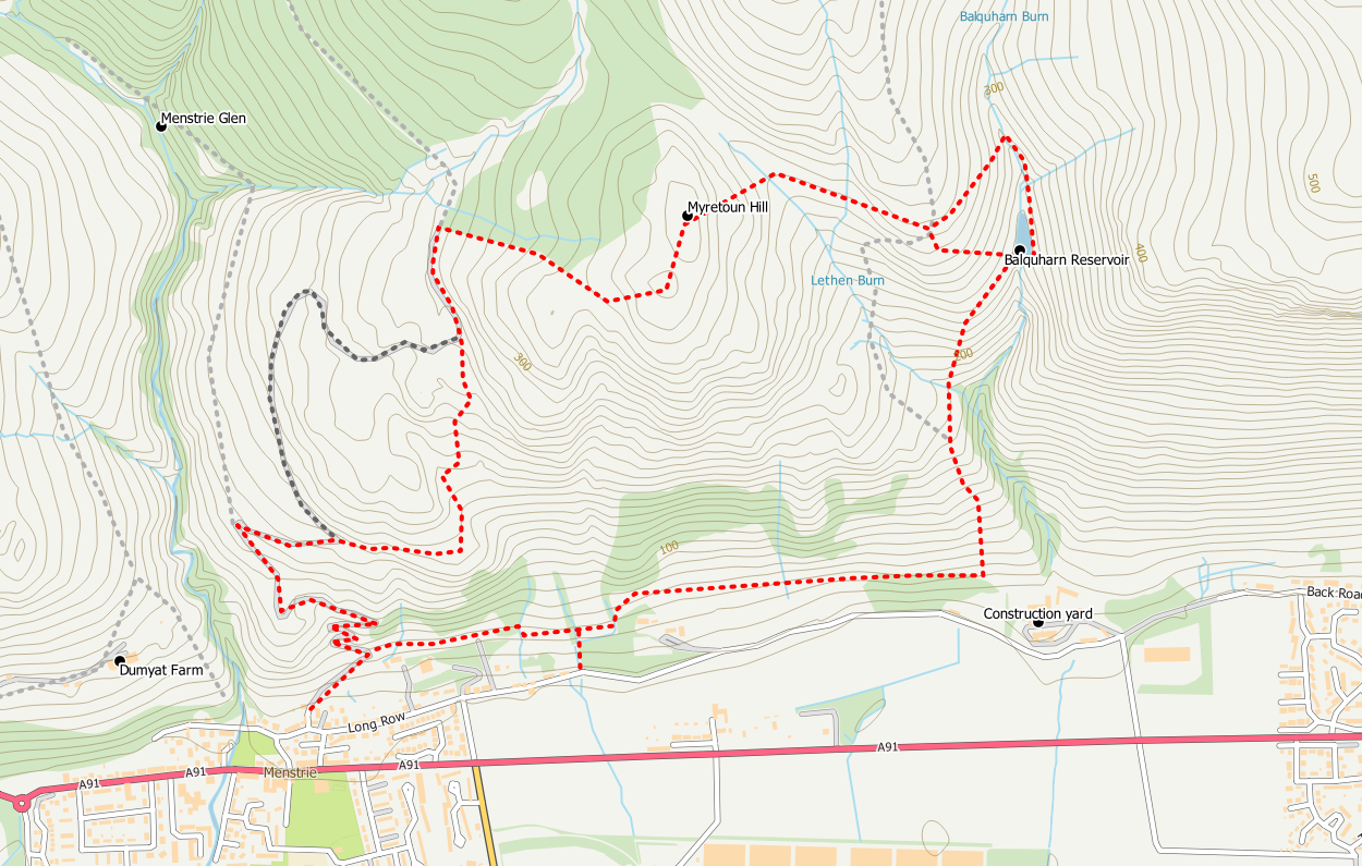
The walk starts from Ochil Row in Menstrie where there is room for considerate on street parking. At the east end of Ochil Row a small lane runs between some cottages and newer houses to provide access via a metal gate to the old Pony Track. This track climbs steeply into the hills via hairpin bends. A number of the zig zags can be short cutt-ed on grassy paths.
The most useful of these “short cuts” is at the left hand bend following the Forestry Operations signage at the end of the Menstrie Glen track. If you follow the grassy path at this point it contours around the south face of a hillock to reach a more open area close to a fence. From this point the path turns left to go up the hill through a newly planted woodland area. Before reaching the tree plantings there is a diversion to your right to the entrance of old mining workings and later a diversion to your left to the site of a dun. The short cut path rejoins the main track where you continue up the hill to reach a deer fence and gate.
Before the gate turn right on to a grassy path on the slopes of Myretoun Hill. The path initially follows the fence line up the hillside only veering away from it when the summit area is approached. At just 387m Myretoun Hill is not one of the highest summits in the Ochils but it does provide a good viewpoint for the Forth Valley.
From the summit descend steeply in a roughly north east direction between the new deer fence and an older wall/fence. This descent is more awkward since the deer fence was erected as you are now confined to the steeper ground. At a boggy dip with a gate in the deer fence, turn east (right) and cross the old wall/fence at a convenient broken section. Once across the wall pick up a feint grassy path in a roughly east direction that crosses the shoulder of Colsnaur Hill. Keep the rocky outcrop to your left as the path takes you to the crest of the shoulder. At this point you reach the fence line again and can pass through a gap in the fence.
From here you have a choice of either following the fence line steeply downhill to reach the small reservoir in Balquharn Glen or for a slightly less steep descent traverse up the glen on the hillside to cross the burn above a waterfall and pick up a visible path on the opposite side of the burn. This path is easy to follow as it follows the left bank of the burn passing a waterfall and crossing over a subsidiary burn before losing height and reaching the reservoir where you cross the dam. A new fence must be climbed before you can cross the dam. Hopefully a stile will be incorporated in due course.
Aan obvious path on the west side follows a fence line down hill above the wooded glen. This path is quite steep in places and could be a bit slippery. It may also be overgrown in the Summer months. Cross the fence when you reach an old stile (a bit awkward due to the gorse bushes) but once on the other side the terrain is easier.. If you reach a burn you have missed the stile. Once across the stile head downhill and cross the burn, then the path joins a wider grassy track that leads down to Balquharn Farm.
Before reaching the farm however, turn right on an obvious and easy to follow path that traverses around the south face of the hill. As you approach The Myretoun the path becomes a bit feinter. Keep the house to your left and look for the path heading into the gorse bushes.
There are now two options available for your return the first one being somewhat overgrown and potentially difficult in the summer months. The second takes you out to the road to avoid these difficulties.
- Follow the path through wooded scrub land crossing a small burn to reach an old wooden gate. Climb the gate and continue westwards on a now feint path and very overgrown path. Gorse bushes and brambles can make it difficult in the Summer months. When you see a deer fence and metal gate to your right aim towards them. From this point an easily walked path now takes you behind Broomhall Castle grounds to rejoin the Pony Track from where you started the walk. Once on the Pony Track it is only a short distance down to Menstrie. December 2022 update: this path is now very difficult to follow after crossing the burn and climbing the awkward gate.
- For the easier alternative, after you cross the burn in the gorse bushes after the Myretoun, go downhill to your left through more gorse bushes (the route may be a bit hard to find but it is there) until you reach a fence. Cross the fence next to an oak tree at a point where the barb wire has been removed. A short easy walk down hill through woodland brings you to a small wooden gate which leads to further woodland. A path now takes you from the gate to a quiet public road where you turn right for a 600m walk back to your starting point.
