Balgownie Woods is a small Forestry and Land Scotland woodland located between Devilla Forest and Valleyfield Woods. Thanks to the hard work of the volunteers of the West Fife Woodland Group there is now a well established path network within the woods linking to existing forest roads. The West Fife Link path was constructed by the group, opening up the old right of way between Devilla and Balgownie and now provides an easy walk between the two forests.
Balgownie Woods can be accessed from either the west or the east. From the west side there is a small informal parking area within the forest at grid reference NS 98407 88596. There is additional parking available on the east side at NT 00056 88337 on the B9037 Blairhall to Shires Mill road.
The woods can be enjoyed on their own by anyone looking for a short pleasant stroll, but they can also be combined with nearby routes for longer walks. Some suggested circular routes are given below. These are only suggestions and many other options are possible.
Balgownie Woods Route Map
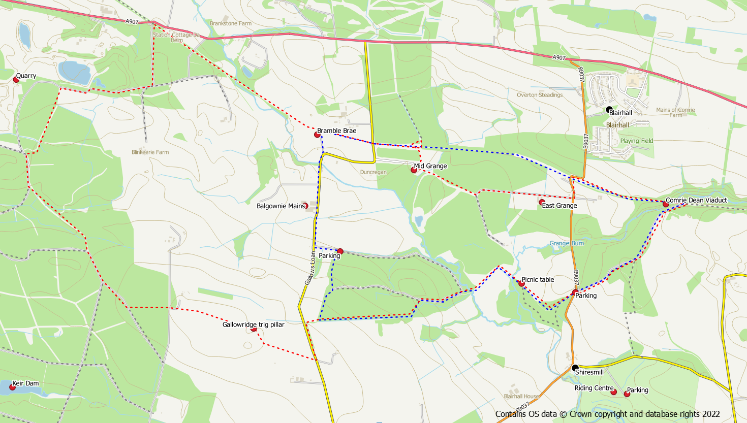
Route 1 – Balgownie Woods Circuit (blue route)
Distance: 8 km / 5 miles
Ascent: 125 m /350 feet
Start / finish: parking area at NT 00056 88337 on the B9037 Blairhall to Shires Mill road
Start the route by heading into Balgownie Woods, through the pedestrian gate, where young birches are growing. At the Balgownie signpost the direct route is to go right, but if you did go left it doesn’t really matter as both routes will bring you to a picnic table at the Grange Burn. Use the bridge to cross the burn after which a good path skirts a wetland area. A further bridge then crosses the Bluther Burn into the forestry area of Balgownie Woods. Keep left for about 300m on the forest track to reach a trodden footpath into the trees on the left hand side. This path takes the walker through birch and oak into a beech avenue. The path then follows the southern edge of the woods along the avenue to reach the western side of the plantation.
At this point turn right on the path into spruce trees. The path heads into the forest away from the boundary fence but keep left at a junction heading back towards the western edge. The path meets up with the main forest track in the north west corner. Going left along this track heads out of the forest (right takes you to a parking area) to the public road.
Turn right on the road for 650m and join the West Fife Cycle Route at Bramble Brae cottage. Walk eastwards (towards Dunfermline) along the cycle track for about 700m passing under a power line. The easiest option is to remain on the cycle track for the next 2km.
However, for the walker who does not like hard surface walking there is the option to use the core path past Middle Grange and East Grange. After passing under the road bridge, bear left onto a grassy trodden path and then turn right on to the core path passing under the cycle route. When Middle Grange is reached turn left (after the yard) and follow a grassy track to a T junction. Keep left at this junction and use the track past East Grange to reach the public road. There is access back on to the cycle track at the corner of the road slightly to the north.
The cycle track then crosses over the Comrie Dean Viaduct after which there is an obvious path leading into the woods on the right. This path is also cycle track and is surfaced. Follow it past some picnic benches keeping right at junctions (following the core path arrows to the left leads to Valleyfield Woods), to join the public road close to the start point car park.
Route 2 – Balgownie with Devilla Circuit (red route)
Distance: : 12 km / 7.6 miles
Ascent : 150 m / 530 feet
Start / finish: parking area at NT 00056 88337 on the B9037 Blairhall to Shires Mill road.
A longer version of the above route can be had by extending the walk into Devilla Forest.
Follow the route as described above to reach the south west corner of Balgownie Woods. At this point keep left (straight on) and left again to follow a path parallel to the road. Once the path joins the road cross over to reach the start of the West Fife Link path on the opposite side. This recently constructed path to Devilla Forest has been described as the “missing link” in the network of paths around the west Fife woodlands and now connects Balgownie and Devilla. Note the OS trig point at the high point on the path approximately half way along the path.
Once in the forest, there is a sign for forest walks on the opposite side of a forest road. From here a trodden (and sometimes muddy) path cuts the corner to rejoin the forest track network. Keep right on the tracks to reach a sharp left hand bend where another unsurfaced path goes left into the trees. This path also rejoins the forest road. Turn right (north-ish) on the road and head up hill to a crossroads. Keep straight on at the crossroads, still uphill. The track now passes a quarry (watch out for quarry vehicles). Keep to the right following the track around the outside of the quarry. Diversions may be in place here as and when quarry activity affects the roads. After a green barrier gate, bear left along a field edge around the outside of the quarry. The path re-enters the forest and becomes a track. Head downhill passing a small parking area. Keep left at farm track junctions to reach the West Fife Cycle Way.
Once on the cycle way, head eastwards towards Dunfermline. It’s just over 3.5km to the Comrie Viaduct on tarmac.
Some of this hard surface can however be avoided by leaving the cycle way for the core paths via Middle Grange and East Grange as described in Route 1. After passing under the road bridge at Balgownie / West Grange, bear left onto a grassy trodden path and then turn right on to the core path passing under the cycle route. When Middle Grange is reached turn left (after the yard) and follow a grassy track to a T junction. Keep left at this junction and use the track past East Grange to reach the public road. There is access back on to the cycle track at the corner of the road slightly to the north.
After the Comrie Viaduct the route turns right into the trees. Pass the picnic benches and keep right at junctions to reach the public road close to the start point.
