Hills: Roscobie HIlls (246m), Lathalmond Hill (245m), Lylowan Hill (241m), Craigluscar (228m), East Hill (209m), Cowdens Hill (207.5m)
These small hills on the outskirts of Dunfermline provide fantastic views of the surrounding area and across the Forth. Craigluscar is a small compact hill, the site of a hillfort, that makes an ideal short walk. For the hill goer, East Hill is a nearby high point which can be combined with Craigluscar. However, there is not a pathed route to this hill and a barb wire fence needs to be crossed.
Route Map
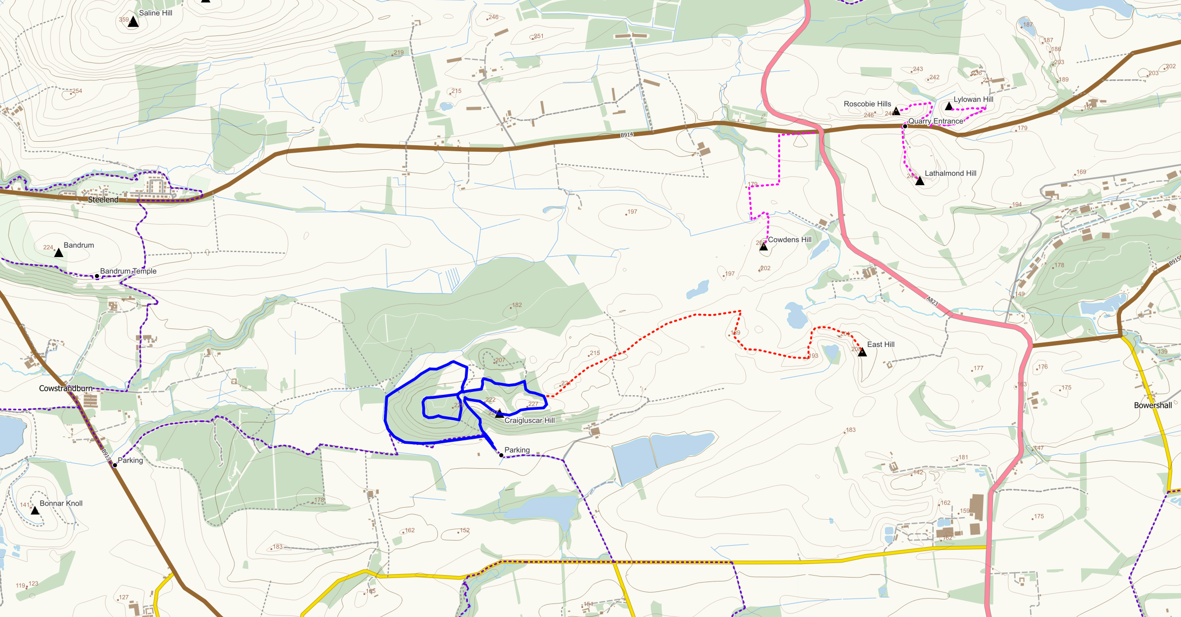
Blue: Craigluscar Hill route; Red: extension (off path) to East Hill, Magenta: off path routes to hills around Lathalmond; Purple: core paths
Craigluscar (228m)
Craigluscar is most easily approached from the south where there is a small parking area at the end of a very rough potholed road. If you need to open the gate across the road please close it after you. There are numerous grassy (though sometimes muddy) paths on the hill, the slopes of which have been planted with young trees.
The direct approach up the hill starts from the parking area at NT 059 907 from where there is a path through mature woodland up the steep south side. Once up you have the option of either going left to explore the high ground to the west or crossing the fence on your right to head for the summit area.
The hill can also be ascended from its more gentle northern side by using a path that circles its western edges. To find this path turn left into the woods after passing through the second gate when leaving the car park. The path becomes easier to follow as it circles around the hill to reach a wall. This wall is the key navigational feature of the hill as it runs roughly north to south over the hill leading back to the car park, splitting the hill. Either follow the paths up the hill or continue to circle around the hill for an ascent from the north east through young woodland.
There are many paths on the hill to explore and a suggested 2.4 mile circular walk with a 120m of ascent, is shown in blue on the route map.
There is a core path route from Cowstrandburn to the west though Carnock Moor woods. However, on approaching the hill this route becomes somewhat rough and awkward to follow. It can be eased by using field edges but this will probably entail dealing with a barb wire fence. Also from Carnock Moor woods is a forest path/track and farm track further north. This route is relatively straightforward apart from having to climb a fence where the path/track exits the northeast corner of the woods. Livestock may be present in the fields so keep dogs under control on a short lead.
East Hill (209m)
This hill, and its neighbour West Hill, combines well with Craigluscar Hill. Starting from the small parking area at NT 059 907, follow the path up the hill, turning right at a broken fence/wall. Follow the path along the summit ridge and downhill to reach a gate at NT 062 910. Go through the gate and keep to the left of the wall to pass through a lumpy sheep field aiming for the ruin of Thornyhill. South of the ruin is a gate into the next field, a rough pasture. Aim for the east side of this field where there is a barb wire fence along with a wall barring access to West Hill. The barb wire fence is probably easiest crossed at NT 072 915 where there is a wooden section that can be climbed. Once over the fence head up the northern slope of West Hill. Close to the summit bump you should be able to pick up a bit of path leading through a gate to the northern side of East Hill from where you can easily reach the summit.
Lathalmond Hill (245m)
This is not the most inspiring of hills but it is a short up and down from the roadside to a high point on a disused quarry edge. There’s room to park a car at the old quarry entrance at NT 08350 92614 on the B914 near Kelty. From here you can squeeze through the fence into the field to the west of the quarry and walk along the field edge. Squeeze through or step over the fence on your left at some point to access the rough grassland surrounding the quarry. Make your way up the grass avoiding gorse, and around the rim to the high point taking care not to get too close to the cliff edges.
Roscobie Hills (246m) and Lylowan Hill (241m)
These two hills form the obvious grassy hummocks on the opposite side of the road from Lathalmond Hill. Starting from the quarry entrance at NT 08350 92614 cross over the road and go through the gate into the field. Follow animal tracks around the eastern side of the hills for a gentle ascent from the north side.
Descend to road at Roscobie Farm entrance in order to make use of convenient gates. Then use the farm track (branching off left) to reach the summit of Lylowan Hill with its wind turbines.
Cowdens Hill (207.5m)
The quickest approach to this wee hill is through the sheep fields to the north or east. Once over the fields a barbwire fence needs to be crossed and this is easiest achieved in the southwest corner at NT 07475 92070. The burn in front of you now needs to be crossed. This can be done without wet feet by following it northeast to reach a wooden crossing point. Head up the rough pasture (cows may be present) to reach the high point 170m to the south.
