Devilla Forest is a Forestry and Land Scotland commercial site to the north and east of Kincardine. There are many tracks and paths in the forest offering numerous possibilities for walking. A few route suggestions are given here but there are numerous other possibilities. Some of the routes are on unsurfaced trodden paths which can be very muddy at times. If this doesn’t appeal, just stick to the surfaced vehicle tracks and the boardwalk of the red squirrel way.
Please note that as this is a working forest, from time to time forest operations may mean some areas are not accessible.
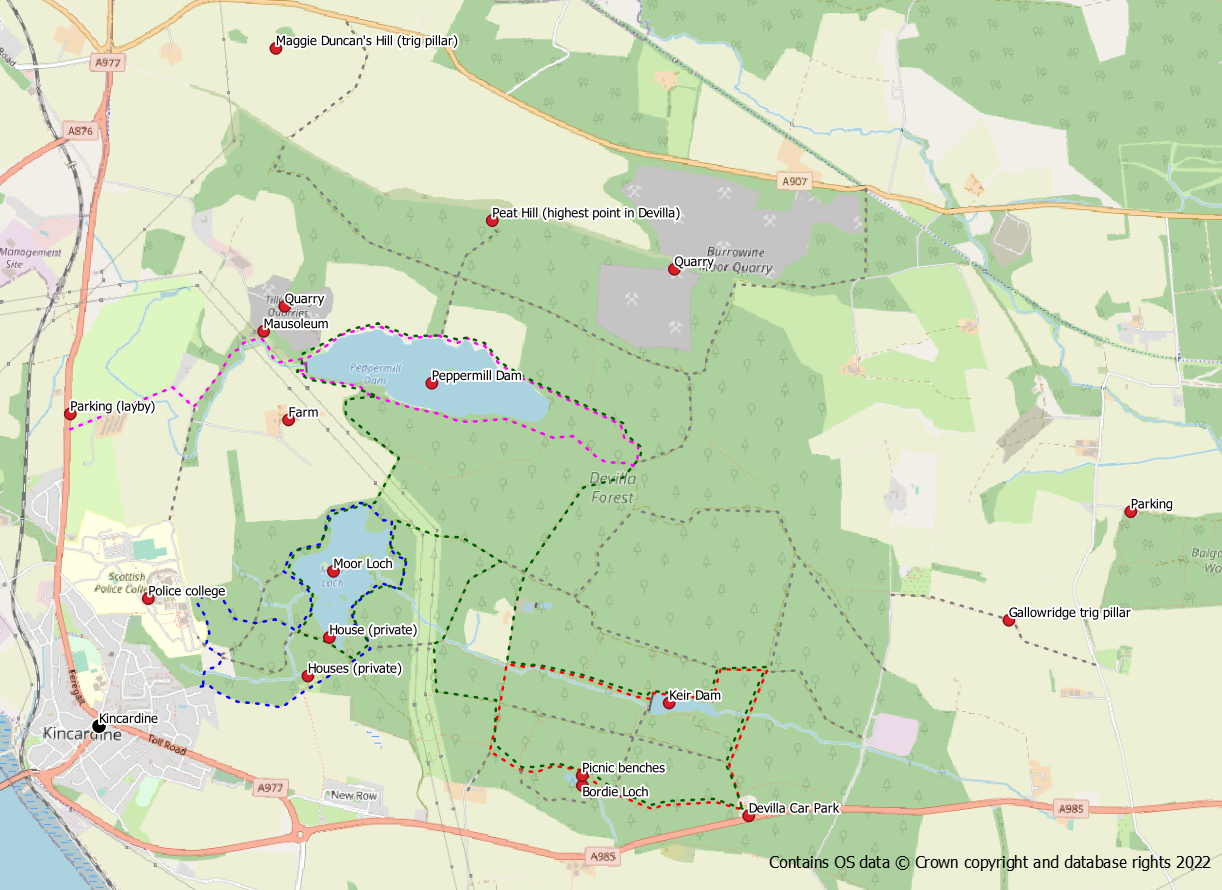
Devilla Route Map
Route 1: Bordie Loch and Keir Dam (red route)
A short walk which is essentially an extension of the waymarked red squirrel walk.
Distance: 2.5 miles / 4 km
Ascent: 160 feet / 50 m
Start / finish: Devilla Car Park off A895 near Kincardine – grid ref NS 964 871
From the car park follow the red squirrel route to Bordie Loch. At the loch there is a choice of going around it either to the north or the south. The northern path has less ascent and better views. At the far end of the loch close to the Pulpit stone when the path starts to bear left to circle the loch, is a rough (sometimes muddy) path into the trees. A marker post with a red stripe is helpful for finding it. The correct path heads west (not north) for about 200m to join a forest track . Turn right on to this track, keeping straight on at a crossroads, to reach an open area to your left.
A rough path at this point (NS 952 878) heads right (east) into the trees alongside an old broken wall and small burn. After about 750m the path arrives at Keir Dam. Go clockwise around the reedy loch to its eastern end. The path turns through 90 degrees left, heading northwards, to reach a forest track. Turn right on the track (east) to reach a crossroads. Go right at the crossroads and follow the track back to the car park.
Route 2: Moor Loch and Tulliallan Woods (blue route)
A 3 mile circular walk through what is possibly the best part of the forest. Parts of this walk may be muddy after heavy rain. Moor Loch is the second largest of Devilla’s lochs but is probably the richest for wildlife.
Distance: 3 miles / 5 km
Ascent: 250 feet / 75 m
Start / finish: Osborne Drive, Kincardine (FK10 4RZ) – grid ref NS 936 877
The route starts at the old right of way at the east end of Osborne Drive in Kincardine. Follow the path/track into the forest, past some houses and straight on at a crossroads. A sign for Moor Loch and the Danes Camp points left into the forest along a trodden path. The path is an attractive (though muddy) walk around the eastern side of the loch, particularly colourful in early summer when rhododendrons and flag iris are in bloom.
On reaching a vehicle track, turn left to skirt the north and west side of the loch through spruce trees. Once round to the west side, a track to the left leads down to the loch shore to an old outflow area where irises and reeds grow. Cross the outflow and follow a trodden path anti-clockwise alongside the shore and across the dam. After the dam, the path turns away from the loch and becomes a bit more indistinct. On emerging from the trees turn right on a forest track.
At the next junction (crossroads) a trodden path path goes straight on into the woods to reach the ruin of the old laundry house. Follow the path round to the left, turning southwards past rhododendrons. The conifers give way to deciduous beech and the remains of an ice house are passed. Turn left (away from the gate into Tulliallan Police College). Keep right at the first junction and look for an unsurfaced path to the right. Although muddy the path is easy to follow downhill to cross a burn at a small wooden bridge. It then climbs back up the opposite bank to the right of a fence from where a narrow track leads back to the right of way into Kincardine.
Route 3: Peppermill Dam (magenta route)
Peppermill is the largest of the four Devilla lochs and the walk along its northern shore has a much more open feel to it than other parts of the forest.
Distance: 4.5 miles / 7.2 km
Ascent: 330 feet / 100m
Start / finish: layby north of Kincardine on A977 – grid ref NS 879 810
From the layby a farm access track leads into the forest passing the golf course. Keep right at the first junction heading towards Windyhill Farm. Turn left on to the path in the woods which leads up to the dam, passing under power lines.
Cross the dam wall and follow the path clockwise along the northern side of the loch keeping close to the water. After about a mile, at the eastern end of the loch, the path enters the forest and reaches a junction of forest tracks. Take the right hand track to turn back towards the loch. The path now makes its way along the south side of the loch back to the dam. Take care to keep close to the loch when the main path turns left. When you reach the dam, cross the lade to return to the path that leads out to the road. Before heading back to the road though, it’s worth making a short detour to the nearby mausoleum.
Route 4: Four Lochs Circuit (green route)
This 8 mile circular route visits all four of the Devilla lochs. The route is described starting from the main Devilla car park but if started from Kincardine a wander through Tulliallan Woods could also be included.
Distance: 8 miles / 13 km
Ascent: 410 feet/ 125 m
Start / finish: Devilla Car Park, A985 near Kincardine – grid ref NS 964 871
From the car park follow the red squirrel route to Bordie Loch. At the loch there is a choice of going around it either to the north or the south. The northern path has less ascent and better views. At the far end of the loch close to the Pulpit stone when the path starts to bear left to circle the loch, is a rough (sometimes muddy) path into the trees. A marker post with a red stripe is helpful for finding it. The correct path heads west (not north) for about 200m to join a forest track.
Turn right on to the track and then go left at a crossroads. Follow the track round to the right, turn right at a T junction and follow the path round to the left (the power lines should now be on your left). At the next T junction go left and pass under the powerlines. Soon after the powerlines a trodden path turns left into the trees southwards alongside the Moor Loch. Yellow flag iris and rhododendrons bloom along this section in early summer. Pass the area of the Danes Camp and Curling Pond before following the path out to a forest track. Turn right on the track and then right again passing a fenced area and house. Turn right after the house and look out for a rough trodden path heading into the trees to the right. Follow the path to the old dam and turn left to cross the dam and follow the shore to reach an old outflow area. Cross the outflow and turn left on to a track back to the main forest track network.
Turn right onto the track following it around the north western corner of the loch to reach another junction. Go left this time, uphill under the power lines, to reach the Peppermill Dam. Turn left to walk clock-wise around this loch. Cross the lade and walk across the dam wall to reach the northern shore. Follow this path keeping close to the water to reach the eastern end of the reservoir where the path goes into the forest and reaches a multi-way junction.
Take the second right option heading approximately south west on a vehicle track into connifers. Keep straight on at the crossroads to reach an open area on the right. After the open area, at NS 952 878 a rough path heads left (east) into the trees alongside an old broken wall. After about 750m the path arrives at Keir Dam. Go clockwise around the reedy loch to its eastern end. The path turns through 90 degrees left heading northwards to reach a forest track. Turn right on the track (east) to reach a crossroads. Turn right at the crossroads and follow the track back to the car park.
