Fife Hills: Park Hill (339m), Kings-seat Knowe (304m), Heights of Craigencrow (296m)
Perth and Kinross Hills: Dumglow (379m), Dummifarline, the Inneans (336m), Georgeton Hills (349m)
The Cleish Hills straddle the boundary between Perth & Kinross and Fife. Made up of tussocky grass moorland (wet at times) they have a real hill feel to them despite not being particularly high. The highest point Dumglow lies within Perth and Kinross, but at 339m the nearby Park Hill is the seventh highest hill within Fife. Although Park Hill could be approached from the Fife side, it is probably best included with an ascent of Dumglow.
The routes here all start and finish from the same point and can be mixed and matched to create your own circular walk. A descent via the Dummifarline and Inneans route is recommended as it is very flexible allowing you to include or miss out the wee hills as you wish.
Start / finish: End of the forest track at grid ref NT 093 971 on the Cleish road. There is space for a couple of cars in laybys or on the verge at this point.
Terrain: Grassy hill paths which can be wet and muddy, plus some forest track. Off path moorland walking is required if you want to go across to Park Hill. Some of the forest paths are obstructed by fallen trees and will require to be walked around or climbed over.
There is ongoing forestry work in the area with much recent felling and replanting. Tracks/paths can be subject to change to accommodate this work.
Some of the paths in the forested areas have been obstructed by wind blown trees making them difficult in places. Be prepared to walk around trees, climb over them, or take a slightly different off path route.
Route Map
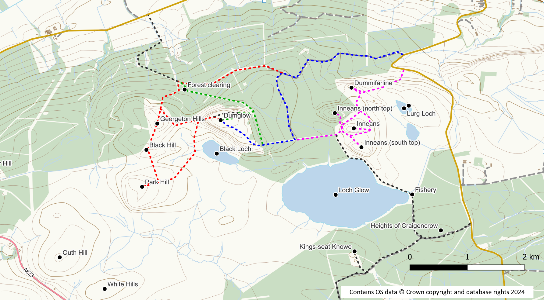
Dumglow Direct (blue route on map)
Distance: 2.8 km / 1.7 miles
Ascent: 180 m / 590 feet
Head up the forest track for 1.3km with views left across to Dummifarline. Go left at an obvious track junction for 700m to reach the end of the track with a signpost. Turn right here heading uphill on a sometimes wet path through a firebreak to reach the edge of the trees. Unfortunately parts of this path / firebreak are now obstructed by fallen trees and it will be necessary to leave the firebreak to make your way around them. Once out into the daylight, a rough path leads to a stile and the open hillside. Once across the stile the grass path to the summit is fairly obvious. This route is shown in blue on the route map.
Dumglow via Windy Gate (with Georgeton Hills and Park Hill) – red route on map
Ascent: 5 km / 3.1 miles (with Park Hill)
Distance: 280 m / 920 m(with Park Hill)
Distance: 3.5 km / 2.2 miles (without Park Hill)
Ascent: 225 m / 740 m (without Park Hill)
Again head up the main forest track but keep straight on at the junction. The track now starts to deteriorate and becomes nothing more than a wet path as it crosses an open area. On the far side of the cleared area, the path re-enters the forest and is a bit drier before reaching a more obvious track.
Turn right on the track for about 70m to reach a firebreak where the ground is somewhat churned up by forestry operations. Turn left into the firebreak where a path soon starts to appear. Ignore a chink of daylight to your left and follow the muddy path to your right through dark trees. It will soon bring you to the edge of the forest at NT 069 967. The line of the path is slightly different from that shown on the OS Explorer map.
At this point you can head straight for Dumglow or include either or both, the Georgeton Hills and Park Hill.
If aiming directly for Dumglow turn left across the grassland roughly following the edge of the forest. A feint path can be picked up which makes use of gaps in the walls/fences to reach the steep western slope of the hill.
To include the other hills, follow a feint track uphill to the summit of the Georgeton Hills in front of you. Continue southwards to cross a wall / fence on to pathless terrain. Head over the rise of Black Hill and down to a rather wet dip with Park Hill in front of you. It is probably easiest ascended by keeping left and tackling it by its eastern slope.
From Park Hill summit descend down the eastern slope but bear right so that you are heading towards the bulk of Dumglow rather than back to Black Hill. The wall / fence needs to be negotiated again as does some wet ground. Aim for NT 072 964 where you can pick up the path to the foot of Dumglow.
From the foot of Dumglow, the easiest line of ascent is on the left hand side of the wall which runs up the hill where a grass path can be followed around to the north side. From the north there are a couple of points where the barb wire fence can be easily crossed to reach the summit. Alternatively walk round to the north east corner to join a grassy track to the summit. The right hand side of the wall can also be followed for a steeper ascent.
This route is shown in red on the route map.
Dumglow from the north east – green route on map
Distance: 3.3km / 2 miles
Ascent: 200m / 650 feet
This is another approach through the forest, keeping straight on at the first junction, and crossing the felled wet area described above. Re-enter the forest on a rough path until you meet with a track.
Turn left on to the track and follow it to a clearing at its termination. To your left is the start of a not so obvious track through the forest heading south east towards Dumglow. Once on the track it is easy enough to follow although it can be wet and rough in places. The track gains height before turning right when you reach the north east corner of Dumglow. A grassy track now heads directly up the hill, crosses the fence and takes you to the summit.
This north east corner can also be reached from the direct route by using a firebreak through the trees starting at NT 08036 96289.
This route is shown in green on the route map.
Dumglow via Dummifarline and the Inneans – magenta route on map
This is a more open route with less forestation than the previous routes. Four optional hills (Dummifarline and the three Inneans) can all be included if desired.
Distance: 3.5km / 2.2 miles
Ascent: 260m / 850 feet
From the parking area walk up the road round the corner to reach a gate on your right hand side on to the hill. A feint grass path can be followed up the hillside. The path splits and either option can be used to reach the base of the obvious craggy Dummifarline hill fort summit. If missing out Dummifarline, then stick with the left hand fork. From Dummifarline descend south-east to rejoin the path that leads to the Inneans.
The middle and southern Inneans are both grassy lumps which although steep are small and present no difficulties. Include one or both of them or stick to the paths which circle around the middle Innean if you wish to avoid them.
After these two Inneans at grid ref NT 087 963 a gate provides easy access through the deer fence to the west. Once through the gate there is the option to include the more awkward northern Innean. Make your way across rough felled ground to the foot of the hill and then ascend its steep south eastern slop to the tree clad summit. Return to the foot of the hill and back to the gate. If you are tempted to cut across the felled ground to the south west be aware that it is VERY wet underfoot.
From the gate in the deer fence it is a straightforward (though sometimes wet and muddy in places) walk on a path alongside felled forestry to reach a track junction with a signpost. Keep straight on up the firebreak path (leaving the path to avoid the fallen trees) to reach the open hillside and a stile with a core path marker. Once over the stile an obvious grass path leads to the summit.
This route is shown in magenta on the route map.
Two alternative points of access to this area are possible (shown in grey on the route map).
- A gate from the road at NT 097 964 provides access to a path passing two lochans to reach the Dummifarline area.
- From the start of the Loch Glow fishery road at NT 100 955 you can walk up the track to the fishery car park, and across the dam. A path around this side of the loch takes you to the vicinity of the southern Innean. If you are tempted to walk around the western end of the loch be warned that it is very boggy!
Kings-seat Knowe and Heights of Craigencrow
These two “hill-lets” are located in the forestry south of Loch Glow. Both qualify as TumpBeags (hills with 15 – 19m of prominence). Both hills are easy to access and Heights of Craigencrow is literally only a stone’s throw from the forest track. Start from the forestry road end at NT 100 955 and follow the track to an obvious junction. Heights of Craigencrow is the high point off to the right here just before the junction. Although only a very short distance the ground is quite rough and new trees have been planted.
Proceed to Kings-seat Knowe by keeping left at the junction (away form Loch Glow until a further junction is reached at NT 089 950. From this point follow a grassy fire-break up to the summit area. The actual summit is just over the other side of the fence.
You may also be interested in exploring the Cleish Hills West area.
