This mixed coastal and woodland walk takes in some of the highlights of West Fife including the lovely Valleyfield Woods (well known for their snowdrops) and the picturesque village of Culross. Much work has been done on the footpaths in the area by the hardworking volunteers of the West Fife Woodlands Group.
A number of options are available for this walk depending upon how long a walk you want. The routes below are only suggestions and it is very easy to adapt them into your own routes. Other short walks in the area include a circuit of Preston Island or the walk out to the West Kirk from Culross, returning along the coast. Valleyfield Woods by themselves are also worth spending sometime exploring, particularly in the Spring when the snowdrops are in bloom. Linking these walks to the paths in Devilla and Balgownie Woods is also another possibility.
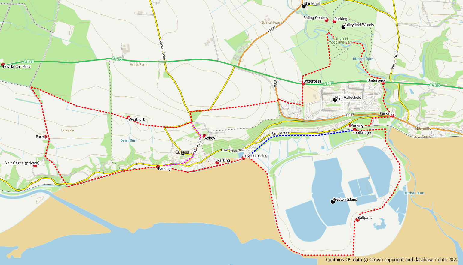
Start / finish: Culross (car parks at Newmils and Valleyfield Woods could also be used)
Facilities: Free car parks (Culross and Newmills), bus service to Culross, toilets in Culross, refreshments in Culross
Terrain: Tracks/surfaced paths around Culross and Preston Island. Unsurfaced paths in woodland which may be muddy after heavy rain.
Route Map
Options
Culross and Valleyfield
Distance: 4.5 miles / 7.2 km
Ascent: 350 feet / 105 m
Culross and Valleyfield with Preston Island
Distance: 6.3 miles / 10 km
Ascent: 400 feet / 120 m
Culross and Valleyfield with the West Kirk
Distance: 7 miles / 11.3 km
Ascent: 440 feet / 135 m
Culross and Valleyfield with Preston Island and the West Kirk
Distance: 9 miles / 14.5 km
Ascent: 490 feet / 150 m
Culross and Preston Island (all routes)
The full route is shown in red on the route map with shorter options shown in blue and magenta.
From the Culross West car park, head east on the coastal path alongside the Forth. This surfaced path hugs the coastline behind the village. After crossing a level crossing (take care because this line is used for freight trains from time to time), a path junction is reached.
Option 1 – With Preston Island Circuit
To include a loop around the reclaimed land of Preston Island go right at the junction. There is path around the outside of the Longannet ash lagoons, with views across the Forth. When the path starts to go inland the site of 19th century salt pans is reached. Beyond the salt pans the path brings the walker back to the railway line and into woodland. A footbridge over the railway is soon reached.
Option 2 – Without Preston Island (blue option on route map)
Keep left and follow the waymarked Fife Coastal Path through the woods alongside the railway until a footbridge is reached.
Valleyfield Woodlands (all routes)
Cross over the railway bridge to reach a car park on the northern side. From the east end of the car park there is a path that can be used to reach the public road. Turn right on to the pavement for a short distance to reach the road junction. Cross the road to the northern side.
Enter Valleyfield Woods on the path at the information board and follow the path above the river under the A985 road bridge. The path continues on the other side of the bridge now at river level. Stay on this side of the river until after an obvious junction with a core path sign (purple arrow). Bear right at this junction to stay close to the river and cross over at a bridge. The path continues on the opposite bank of the river until a further junction is reached. Turn left to cross back over the river on a stone bridge. The path now goes up hill slightly and the previous core path rejoins from the left. The path now crosses open ground as it heads south to the main road and an underpass.
After the underpass keep to the path until a path on the right into a housing estate is reached. Take this path through the houses to reach the B9037 road. Cross over the road and on the opposite side is another path.
This next path is a pleasant walk in a westerly direction with open stretches giving views over the Forth. At the end of the path is a quiet road. Follow the road and turn left at a junction walking south. A further junction is reached after 120m.
Return to Culross (all routes)
Option 1 – Direct (magenta option on route map)
Keep strtaight on down the hill passing the abbey. From here it is a short walk downhill back to the village centre. If heading to the east car park there is a grass path to the side of the abbey that can be used.
Option 2 – West Kirk Circuit
To continue with the West Kirk circuit go right at this junction still on a quiet road. When this road turns sharply left, an unsurfaced track continues straight ahead. Follow this track to reach the remains of the West Kirk. After the church the path continues onwards but can be quite muddy after heavy rain. After passing through farmland more woodland is reached. Look out for the information board regarding the plague grave in these woods. 1.2km after the church the path reaches a farm access track.
Turn left onto this track and walk downhill towards the Forth passing Blair Mains Farm. At Blair Castle keep left on the access drive and then keep right to walk out to the public road. Cross over the road and go through the gate opposite to reach the coastal path / cycle track. Follow this back into Culross.
