Lomond Hills Reservoirs
- Start / finish: Holl Reservoir car park at grid ref NO 224 034, accessed from the A911.
- Facilities: free car park
- Four Reservoirs Distance: 8.7 km / 5.4 miles; Ascent: 185 m / 600 feet
- Harperleas Woods Distance: 7.2 km / 4.5 miles; Ascent: 140 m / 460 feet
- Three Reservoirs and Harperleas Distance: 10.5 km / 6.5 miles; Ascent: 200 m / 650 feet
- Terrain: Paths and tracks. Some surfaces can be muddy at times especially in Harperleas Woods.
Route Map
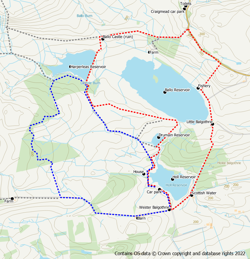
Four Reservoirs Circuit (red on route map)
From the car park walk back down the road to the crossroads at West Balgothrie Farm. Go left (signed for Craigmead) past the Holl Dam. After passing the water works the road becomes a trodden path through the woods and can be a bit muddy at times.. The path gains height through the woods and then through fields to reach Balgothrie. Follow the paths, through gates, round the left side of the farm and pick up the path going around Ballo Reservoir keeping the reservoir to your left. At the fishing hut, the path turns right, through a number of gates and heads uphill across grassy fields. An openable gate provides access to the public road at the end of the path.
Turn left onto the quiet road and continue uphill for 750m to reach the Little Ballo farm road on your left. The route heads along this road but you may wish to make a detour to the picnic area and toilets at Craigmead which is a further 300m up the road. Follow the farm road above the Ballo Reservoir, keeping straight on (not downhill to the farm) to reach the ruin of Ballo Castle.
After the castle, go left downhill on grass and cross the Harperleas Dam. On the opposite side turn left on to the forest track through Harperleas Woods. Approximately 200m after exiting the wood keep an eye open for a wall on your right hand side. Turn left at this point onto a grassy path across rough grazing walking towards the large Ballo Reservoir. This area is used by ground nesting birds so if you have a dog, keep it under control and to heel during the nesting season. When you reach a surfaced track, turn left heading towards the dam. At the dam the track bears right and heads in the direction of Drumain Reservoir, the smallest of the four.
When you reach the reservoir cross over the dam and the outflow on the bridges. Go straight on (the track goes right) over the rough grass towards a gate in front of a clump of trees. It’s easy walking and there is a feint path. When you reach the gate turn left onto the road and follow it back alongside the Holl Reservoir to the car park.
Harperleas Woods Circuit (blue on route map)
From the car park follow the road/track north west alongside the reservoir and then across open farm land (may be sheep in the fields). After about 2km the track enters the Harperleas Wood. Continue onwards to reach the Harperleas Reservoir dam. Stay on the track (do not cross the dam) with the reservoir to your right.
After a further 0.5km you will reach a path on your left heading into the trees with a small sign for Harperleas Woodland. Take this path which leads slightly uphill into the woods. Soon the path reaches the edge of the forest and there are open fields to your left. After the path turns to the right at a fence junction it goes back into the trees again to reach the highest point of the walk where there is an Ordnance Survey trig pillar in the trees on your left hand side. After a turn to the left you reach a small open area. Go straight across this open area continuing in a southerly direction. The path now winds its way downhill to reach the southern edge of the woods.
After leaving the woods keep to your right to follow a path alongside the field edge to reach a farm road. Turn left on to this road and follow it for about 1.6km to reach the crossroads at Wester Balgothrie Farm. From here turn left and walk for about 250m back up the road to reach the car park.
Three Reservoirs and Harperleas Woods
This route combines the above two routes into a longer 6.5 mile walk. Follow the Four Reservoirs Route until you reach the Harperleas Dam. Cross over the dam and instead of going left on the forest track, turn right. Follow the Harperleas Woods route from the dam through the woodlands and back to Holl.
