North Fife Trigs
Brief descriptions of routes to reach Ordnance Survey triangulation pillars located in North Fife.
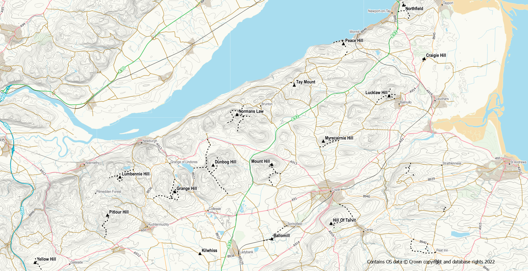
Grange Hill, S4770, NO 25848 14442, Newburgh
This one is located at the high point of forestry don’t expect any view from this one. Access is easiest via a network of forest paths starting either from the minor road to the north opposite Golden Loch on the “Footpath to Red Myre” or from Lumquhat to the west. It should also be possible to access the area from Caldwells to the south. Although the forest track is less than 100m from the trig the final approach is a bit more awkward with brash and trees to be negotiated. More information on this hill (which is listed as Woodheads Hill) and the surrounding hills is available on the Newburgh Hills page
Lumbennie Hill, S4771, NO 21735 15540, Newburgh
This is another forested trig although access to it is reasonably straightforward via a fire break. Lumbennie Hill is the highest point in Pitmedden .Forest. The shortest route into the trig is from Lochmill to the north east using a forest track. Leave the track and use the fire break below the pylons to reach the pillar. More information on walks in the area that include the trig are is available on the Pitmedden Forest page.
Dunbog Hill, S4773, NO 28710 16433, Monimail
Sadly this pillar to the north of Collessie and Monimail is somewhat damaged. The trig is sited to the east of the core path between Monimail and Dunbog/Glenduckie and can be accessed from that track using field edges where crops are growing followed by grassy grazing ground. Alternatively, a track goes higher up the hill around its eastern side and this can also be used for access. Route information for walks up both Dunbog Hill and its neighbouring Marilyn Cairnie Hill is available on the Cairnie and Dunbog page.
Mount Hill, S4774, NO 33112 16490, Cupar
Mount Hill is a prominent feature of north Fife due to the presence of the Hopetoun Monument on its summit. Also at the summit, but less visible from afar, is a trig pillar. There are tracks and paths through the surrounding woods so access is not difficult. The shortest route is from the minor road to the east via The Mount. Detailed route descriptions are available on the Mount Hill page.
Ballomill S4775 NO 33108 10908, Ladybank
Another easy to access trig alongside the core path between Pitlessie and Ladybank. The trig is located on the rough ground between the path and railway line slightly west of where the path passes under the railway.
Myrecairnie Hill, S4788, NO 36968 18234, Cupar
This trig sits at the top of a small wooded hill north of Cupar. The easiest line of approach is from the east using a track and then field edges. The track can also be accessed for the south west via Myrecairnie Farm. The trees at the summit are easily negotiated.
Hill Of Tarvit, S4789, NO 37546 12061, Cupar
A short steep slog up the grassy hillside from the Hill of Tarvit Mansion is all that is required to reach this trig and the summit memorial. The views make the effort worthwhile. For a longer walk there are details of routes that include the hill available on the Hill of Tarvit page.
Tay Mount, S4790, NO 34793 22431, Brunton
This one is just a stone’s throw from the Fife Coastal Path close to Hazelton Walls. Where the coastal path reaches the public road, go left instead of right to reach an open gateway. There is then reasonably easy access following tractor tracks across a field to reach a path heading uphill through the woods. Hop over a stile and the trig is easily reached on rough grassland.
Lucklaw Hill, S4791, NO 41895 21630, Leuchars
This is another obvious landmark in north Fife due to the large quarry on its southern slopes exposing the red felsite. There are a number of routes up the hill (all avoiding the large quarry) from the nearby village of Balmullo. Details of these routes are given on the Lucklaw Hill page.
Normans Law, S4793, NO 30501 20229, Brunton
This is a well known and popular hill in the north east of Fife. The summit trig can be approached from various different directions, the shortest and easiest being from Pittachope to the north. A selection of routes to the summit are described on the Norman’s Law page.
Craigie Hill, S4794, NO 44535 24424, Leuchars
This trig is situated on the rough of Drumoig Golf Course. Take care to watch out for golfers. The easiest access is a 5 minute walk from the B945 to its south via a track from the greenkeepers’ base. Might be prudent to ask permission to walk through their yard if they are around.
Northfield, S4795, NO 42977 28442, Newport-on-Tay
Another trig with a view, this one sits on the hillside above the Tay Road Bridge overlooking Dundee. The quickest access is up the farm track east of the bridge to an old quarry. After which is is an easy walk up hill on grass to reach the trig. It can also be accessed by crossing the fence at the TV mast having reached the mast via the core path from Inverdovat or Newport and then climbing the gate.
Peace Hill, S4823, NO 38477 25535, Wormit
A unique trig to visit as this one has been converted into a memorial and is even topped with a nodding owl. It is on farmland but can easily be accessed by following field edges / tractor tracks from either the Fife Coastal Path or Peacehill Farm (follow signage around the outside of the farm – it’s a busy place). If approaching from the coastal path leave the path at Peacehill Point heading directly up the rough grassy hillside. Once up the slope go through the gate and it is easy enough from there.
Yellow Hill, S5918, NO 15376 09139, Gateside
This is another trig that is not located at the summit of its hill. The true summit of Yellow Hill lies further east in scrub and is well protected by electric fences! The trig is sited in a nearby arable field although it is not too far into the field. Visit when the crops have been harvested or view it from a few metres away. It is easy to access from the farm track between Burnside and Carmore.
Pitlour Hill, S5920, NO 20795 12683, Auchtermuchty
A lovely wee hill though note that the trig is not actually the hill summit. The shortest route is from the Clink car park to the east following field edges and rough woodland paths. However, this route does entail barb wire fence crossing. An alternative longer route is from the south through Pitlour Estate. This route has the advantage of a track for most of the route followed by a quad bike track for the final bit. This is working countryside so be mindful of the Scottish Outdoor Access Code.
Kilwhiss, S4768, NO 27728 09801, Ladybank
Sadly this trig is no more and hasn’t been since 1959 (according to the OS archive). It was located west of Ladybank alongside a minor road.
Log your trig progress at https://trigpointing.uk/
